Many anglers pass up Venice’s spillways this time of year. They’re making a big mistake.
Dear Capt. Paul:
How much memory do you need for maps in a hand-held GPS unit?
Eric Williamson, Lutcher
Dear Eric:
Please do not confuse internal memory that is used to store waypoints, routes and generally operate the unit with the amount of memory needed to store maps or charts in the GPS unit. The waypoint/route type of internal memory was the topic of my June 2003 “Ask Captain Paul GPS” column.
As your question is asking for information about a handheld GPS unit, my answer will exclude those commercial-model GPS chart plotters that may require the GPS unit to be connected to a computer or have a whole series of charts in its memory for extended navigation.
FLASH MEMORY is one of the newest types of DIGITAL MEDIA that can be used over and over again, and is the choice of saving data and maps in GPS units.
Newer FLASH MEMORY technology has allowed a way of saving memory in the GPS unit without being connected to a power source. This flash memory technology has evolved into the current preferred storage media.
Most modern chart-plotting or mapping-type GPS units have the ability to store one or several maps or charts internally.
The amount of memory is usually stored in either of two ways.
The first arrangement is an internal flash memory media chip permanently installed in the unit when it was made. Those GPS units usually specify the amount of mapping memory that the GPS unit can accommodate.
This internal memory configuration may range from 2.5 megabytes (MB) to 64 MB of mapping memory. This type of unit does not allow for a memory upgrade without being returned to the factory and even then a memory upgrade may not be possible.
There is a disadvantage to this type of memory configuration, but there is also a big advantage.
The disadvantage is that you are “locked in” to the amount of memory that you selected when you purchased the GPS unit. Although this sounds very limiting, in reality it is not so. The reason is the maps are downloaded from a computer mapping program designed for the unit.
That means that you simply configure the needed maps for a specific area, up to the storage capacity of your unit, and save them to a file in the mapping program in your computer. There is no limit as to how many of these areas you can configure and save as a file.
If you have the manufacturers mapping software, you can download topographical maps, Bluewater charts, highways, roads and city streets as well as points of interest and national park locations for the covered areas.
When needed, you simply go to the computer file in the mapping program, access the saved file that contains the maps of the area that you need, and download those maps in that file to the GPS unit.
If you have installed the maps around, for example, Toledo Bend, and you now want to use the unit with the mapping features while hiking the Smoky Mountains, you simply configure another set of maps for the Smoky Mountains in the mapping software on your computer and download the maps of that area into your GPS unit.
The new download immediately erases all of the existing maps in your GPS and installs the new ones. This can be used over and over. This rewriting can accommodate over 300,000 cycles and should last more than 10 years. The only requirement is that you have the mapping program designed for your unit, and that it is installed in a computer that can be linked to the GPS unit.
The big advantage is that the memory card is housed completely within the sealed waterproof-shock resistant GPS case housing. This means that there is very little chance of the memory media becoming loose or the contacts corroding, either of which would cause a lack of mapping in the GPS unit. The memory card is protected from the elements just like all of the other internal components in the unit.
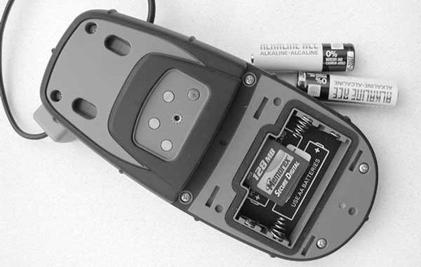
Some other manufacturers, Magellan and later-model Lowrance hand-held units, also use the flash memory concept, but they provide for the mapping data to be installed on a memory card that inserts or plugs into the GPS receiver.
These cards come in a variety of storage capacities, ranging from 8MB to 256MB of memory. Some of the common types are secure digital, used by Magellan, and multi-media card, used by Lowrance. These two different postage size memory cards are not interchangeable.
Some companies even preinstall maps on their memory cards for those of you who do not have a computer.
The obvious advantage is that you can have several of these memory cards each with different maps. In addition, you can have much larger memory capabilities simply by buying a large-capacity card.
A 64MB secure digital card when used with the Magellan MapSend topo map U.S. mapping software can accommodate topo maps that include nearly all of the states of Louisiana, Mississippi, Arkansas, Alabama and Tennessee. A 256MB secure digital card can cover most of Magellan’s TOPO maps of the southern United States.
This is really handy when a computer is not available for a new map download.
The disadvantage is that these cards must be inserted into the circuitry of the GPS. This is usually accomplished by providing the connection point within the battery compartment. This installation is on the safe side of the weather-proofed battery compartment seals, and offers some protection from the elements.
How much mapping memory is needed is up to the user and the details that are shown in the maps or charts. Generally those mapping programs that are displaying topographical maps require more memory than those that are designed for offshore marine charts. This is because the topo maps generally contain a lot more data in the form of contour lines (hills and depressions), small streams and lakes, roads, streets and other man-made features than do the marine charts.
For instance, a Garmin GPSMap 76 with a stated 8MB of memory will accommodate topos from their MapSource CD program that would roughly cover an area that would stretch from Bogalusa to Baton Rouge to Lafayette to the Gulf of Mexico to the mouth of the Mississippi River to Gulfport, Miss., north to Picayune and back to Bogalusa.
As you can see this is a considerable amount of mapping software that is instantly available to the GPS user.
To again prove my point, you will note that when using the Garmin MapSource BlueChart Marine software with the same 8MB of memory, you are able to install all of the marine charts in the Gulf of Mexico that extend from Pensacola, Fla., to Mexico, including all of the Intracoastal Waterway charts. This extended coverage is possible because the marine charts require less memory than a topographical map of the same area.
Garmin’s GPSMAP76S has, in addition to other features, a mapping memory of 24 MBs. This would allow the user to install of the state of Louisiana and parts of Mississippi.
So back to your question, “How much mapping memory is needed in a handheld GPS unit?”
The answer is it is totally your choice. If you don’t mind reloading the GPS with maps of different areas, then the 2.5MB would do. To have the convenience of installing a very large amount of maps that would cover most of your immediate journeys, then you will need additional memory. Generally the more features, including memory, the greater the cost.

