
Great spots southeast of Houma
Lately I have been swamped to provide waypoints for kayak anglers. These requests generally ask for the distances from a launch location to a variety of various waypoints in the area.
Location
My latest request was for waypoints in the Pointe aux Chien area of the Pointe-aux-Chenes Wildlife Management Area.
The name of the WMA is interpreted as meaning “Point of the Oaks,” or Oak Point. Pointe-aux-Chenes WMA is located in Terrebonne and Lafourche parishes, approximately 15 miles southeast of Houma.
For more information on the 35,000-acre WMA, go to http://www.wlf.louisiana.gov/wma/2790.
The Point aux Chien area is generally described as an area west of Galliano and Highway 3235, south of Highway 24, east of Montegut and Highway 55 and north of Lakes Felicity and Courant.
Some locations in the area and south of the WMA were also listed and available in my Capt. Paul’s Fishing Edge of waypoints for Leeville West. Some of you may want many or all of the 340 waypoints in this area.
 Launches
Besides the many roadside launches along the highways, there are some more sites that offer some protection for your vehicles.
One of the western side access points is PAC Kayak Rentals (http://packayakrental.com/; located at 179 Paw Paw Lane in Montegut. (Their email is packayakrental@yahoo.com, and the telephone numbers are 225-244-1547 or 225-573-4085.) Another one is located on Grand Bayou on Highway 665 south of the WMA headquarters. For more information, contact Vaughan McDonald at vmcdonald@wlf.la.gov, or call 225-763-8807.
And on the eastern side of the WMA is the Oak Ridge Boat Launch in Golden Meadow, located at 305 Oakridge Drive in Golden Meadow. The phone number is (985) 537-7603.
Sulphur Lake area
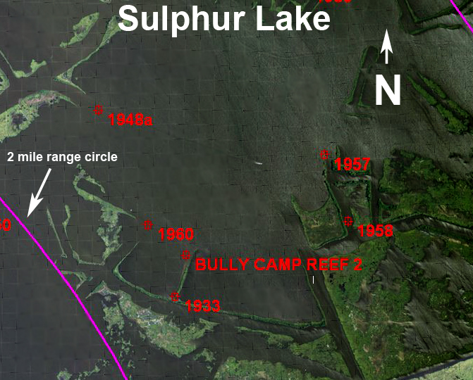 One of the most requested areas is in and around the Sulphur Mine in Lafourche Parish west of Galliano, in the middle of the Point-au-Chien, Golden Meadow and Larose area. It is just northeast of Lake Bully Camp in the Pointe-aux-Chenes WMA.
The south side of the Sulphur Mine Lake, located in the Pointe aux Chenes WMA at a point where Bayou Bouillon (now a canal) enters the lake, is at or about 29º 27.465’ N. Lat. ~ 90º 22.652’ W. Long.
There is another canal that leads from the Sulphur Lake on the west side to Grand Bayou. Grand Bayou then leads southerly to Cut Off Bayou, which intersects Bayou Point aux Chien near the southern end of Highway 655.
The Sulphur Lake at the first mentioned canal is at or about 29º 27.751’ N. Lat. ~ 90º 23.404’ W. Long. The center of the Sulphur lake is at or about 29º 27.765’ N. Lat ~ 90º 22.936’ W. Long.
I do not believe that the center is the deepest part of the lake. The map that I have also shows numerous pilings and some small production platforms throughout the area.
Rings on the map indicate 2 miles as the crow flies.
Additional waypoint locations
Name: 1956 on Grand Bayou
Coordinates: 029° 23.0338’ N, 090° 26.4126’ W
Comment: Wildlife headquarters.
Name: 1959 break in the canal north of Sulphur lake
Coordinates: 029° 28.2074› N, 090° 22.5305’ W
Comment: Fish the break in the canal banks.
Name: 1960 ~ beginning of where canal began at Sulphur lake.
Coordinates: 029° 27.3405› N, 090° 23.1928’ W
Name: BYU6BLUE ~ near end of canal by BYU Blue
Coordinates: 029° 30.7801› N, 090° 22.3552’ W
Comment: Fish the cut for reds in a NW wind.
Name: CHIEN ~ LK CHIEN BYU TO BYU JEAN LACROIX
Coordinates: 029° 20.8527› N, 090° 25.8468’ W
Comment: Fish the opening to the NW and the structure to the east.
Name: COUPE- CREUSE ~A REEF LOCATED BETWEEN COUPE CREUSE AND LAKE DU DIABLE
Coordinates: 029° 15.9471› N, 090° 26.4128’ W
Comment: Fish north end of the reef to shoreline.
Name: LK FELICITY WEST
Coordinates: 029° 19.0361› N, 090° 27.2955’ W
Comment: Fish the cove.
Name: 13FTHOLE
Coordinates: 029° 04.1770› N, 090° 14.9086’ W
Comment: 13 feet in Timbalier Bay.
Name: 50 DEEP HOLE
Coordinates: 029° 12.9950› N, 090° 31.4280’ W
Comment: Find the hole on depth finder and fish the sloping sides to the north.
Name: BARREN ~ USGS MARKER MARKING WHAT WAS A SHOAL
Coordinates: 029° 16.5165› N, 090° 32.3270’ W
Comment: Fish around the position.
Name: CATLKS ~ CATFISH LAKE, SOUTHERN CUT
Coordinates: 029° 21.9048› N, 090° 17.8767’ W
Comment: Cut to Pipeline Canal, fish the points.
Name: DEEPLK-CHINA ~ NAVAID GREEN #1 DEEP LAKE AT CHINOS PASS
Coordinates: 029° 17.6358› N, 090° 20.8906’ W
Comment: Fish the deeper channel marked by the Navaids – Also the points in China Pass.
Name: G BYU WEST
Coordinates: 029° 21.1196› N, 090° 19.5413’ W
Comment: Fish the shoreline and the points.
Name: Golden M launch
Coordinates: 029° 22.4186› N, 090° 15.8320’ W
Name: BYUBLUE 3 ~ BYU BLUE AREA
Coordinates: 029° 29.9157› N, 090° 21.9798’ W
Name: CATL-BLUE CATFISH LK @ GRAND BYU
Coordinates: 029° 22.5603› N, 090° 19.7672’ W
Comment: Fish the points at each canal.
Name: CATWEL2~ ONE OF MANY, MANY WELLHEADS
Coordinates: 029° 23.0175› N, 090° 18.6642’ W
Comment: Fish the structure on the current side.
Name: CATWELL ONE OF MANY, MANY WELLHEADS
Coordinates: 029° 22.6505› N, 090° 18.3383’ W
Comment: Fish the structure on the approaching current side.
Name: 1957 ~ Sulphur lake where canal ends
Coordinates: 029° 27.5978› N, 090° 22.4532’ W
Name: 1958 ~ CANAL SOUTH OF SULPHUR LAKE
Coordinates: 029° 27.3529› N, 090° 22.3539’ W
Name: OLD LADY-CREUSE ~A PASS BETWN OLD LADY LAKE AND COUPE CREUSE
Coordinates: 029° 14.7655› N, 090° 26.8292’ W
Comment: Fish the pass and island to the south.
Name: OLDLDYS ~ UNDER WATER SHOAL IN OLD LADY LAKE
Coordinates: 029° 12.4411› N, 090° 25.9791’ W
Comment: Fish south of Old Lady Lake.
Name: BULLY CAMP REEF 2
Coordinates: 029° 27.2290› N, 090° 23.0349’ W
Name: 1933 OPENING BETWEEN REEF
Coordinates: 029° 27.0770› N, 090° 23.0773’ W
Comment: Fish the cut on both sides.
Name: 1935 ~ canal north of Sulphur lake
Coordinates: 029° 29.4418› N, 090° 23.1384’ W
Comment: Fish the break in the canal, and fish both sides.
Name: 1948 ~ canal opening west side of Sulphur Lake
Coordinates: 029° 27.7584› N, 090° 23.4007’ W
Comment: Fish the bank on both sides.
Name: 1949 ~ canal end north of Bully Camp Lake
Coordinates: 029° 27.2415› N, 090° 24.1427’ W
Comment: Fish the break.
Name: 1950 ~ Island north of Lake Bully Camp
Coordinates: 029° 27.3732› N, 090° 23.9551’ W
Comment: Once land, fish the north side of the island.
Name: 1951 ~ North of Bully Camp lake.
Coordinates: 029° 27.3745› N, 090° 24.4646’ W
Comment: Fish the break in the canal.
Name: 1953 ~ a rock dam.
Coordinates: 029° 26.1778› N, 090° 26.3122’ W
Comment: Fish the small break.
Note: Some of these waypoints may now be listed as private property. Please obey all trespassing laws.
Unless otherwise specified, all positions are stated as H,DDD,MM.mmm and were determined using WGS 84 DATUM. All Headings/bearings/courses are stated in magnetic degrees.
All of Capt. Paul’s Fishing Edge files can be found in Louisiana Sportsman’s Outdoor Store (www.sportsmangear.com). Remember that you must state your brand of GPS unit, your email address and the selected area.
NOTE: Edge files are NOT brand name interchangeable, so be sure to make the correct GPS unit brand selection.

