Public land hunting can be challenging, but this hunter consistently puts deer on the ground in the Kisatchie National Forest. Here’s how he does it.
Computer power and memory storage are gaining speed and capacity while losing bulk, and I’m happy to report that these evolutionary steps are impacting the world of marine electronics. Today, bracket-mounted GPS chart plotters and combination sonar/chart plotters are able to do what only PC-based systems could accomplish over the last decade. That’s good news for those of us with open boats that aren’t well suited to PC systems.
C-Map and Navionics, two of the largest electronic cartography companies in the world, offer charting chips with PC-system styled features that plug right into many new bracket-mounted units.
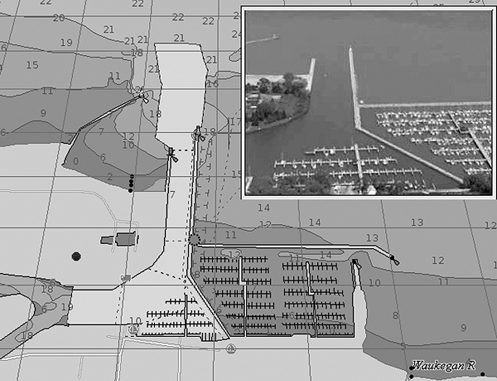
Imagine approaching a marina and being able to display a chart picture of it, along with a satellite photo of it, and maybe a panoramic photo of the entrance that you are about to see for yourself.
And, while navigating to a waypoint, you can choose a forward-looking screen view of your chart that appears as if it were viewed from a point a few hundred feet above your boat, a view that more naturally approximates how we see islands, points and marinas as we approach them.
Navionics Platinum series charts include satellite photography, panoramic port photos, 3D bathymetric bottom presentation, coastal piloting guide text, a wrecks database, detailed coastal road networks and enhanced port service information. The system dissolves charts into a satellite photo of the local area making it easier to see features like water tanks, towers and buildings that may not be on ordinary charts.
Inland boaters should check out Navionics’s HotMaps Premium series of lake maps including some of the country’s most-famous bodies of water recently surveyed in high definition and shown with 1- to 3-foot depth contours. For more information on all Navionics products, call them at 508-291-6000 or visit navionics.com.
C-Map’s new Max series of charts includes features like: aerial photos and diagrams of marinas; seamless coastal roads with points of interest information; a worldwide, fully animated tides and currents database; dynamic elevation data that shows land elevations in 15 contour levels and bottom depth contours in 32 levels, both shaded to make contour differences pop out on the screen; and dynamic Nav-Aids that can be animated to show their correct flashing light sequence.
Fexizoom allows under-zooming with no increase in clutter and over-zooming to a much greater magnification than was previously possible.
Inland fishermen should appreciate C-Map’s MAX Lakes series which divides the country into four regions and includes data on some 3,300 lakes.
Lake depth contours and structure detail come from various sources including Lakemaster Pro maps that show some lakes in the upper Midwest in 1- to 3-foot contours. A fish database is also included. Just click on a fish icon and you can bring up a color picture of a fish, find out where and at what times of the year it can be caught most successfully, what kind of baits work best, what rules and regulations are involved, and you get a description of the state-record fish including when and where it was caught.
Since many fishermen also hunt, C-Map includes rules and regulations for hunting waterfowl, upland birds and other game animals for each state as well. For more information, contact C-Map at 800-424-2627 or visit c-map.com.
Companies that offer proprietary mapping software are also getting into the act. Garmin’s new chart plotters can show a weather overlay right on top of the chart picture on your screen. It’s like having your own weather radar, so you can avoid storms. You can even see wind strength and direction on coastal and offshore areas.
Contact Garmin at 913-397-8200 or visit garmin.com.
Other advances include Lowrance’s newest LCX series units that include built-in hard drives that come pre-loaded with all of Lowrance’s mapping and charting software. Hard drive models cost about $200 more than Lowrance’s conventional models, but you get about $2,000 worth of electronic charts and maps that were previously sold one region and one type at a time. You can also plug in Navionics’ map and chart cards if you prefer their style of detail.
Contact Lowrance at 800-324-1356 or visit www.lowrance.com.
")

