
This Lafourche Parish winter hole can seem more like a gold mine for trout anglers. Here’s one local guide’s Top 10 hotspots for the area — and a detailed map with GPS coordinates to get you there.
Saltwater anglers have long been at the mercy of the wind more so than freshwater anglers. The very nature of fishing sprawling bays and open lagoons along a wide-open coast means wind direction and strength must be taken into account before and during every trip.
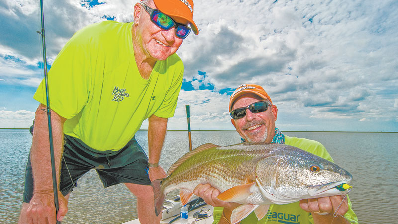
“The wind affects the fishermen more than the fish,” said Capt. T-Man Cheramie who guides out of Bayou Blue in Larose. “March can seem like tough fishing because of all the wind, but wind is a good thing. It stirs everything up and puts more oxygen in the water. It mixes up the water and moves the bait around. Nothing stays still around the Sulphur Mine during March.”
The Sulphur Mine that Cheramie mentioned is the famous winter trout hole just to the west of Galliano in Lafourche Parish. The entire area is located inside the border of the Point-aux-Chenes Wildlife Management Area, which makes it one of the last places in the parish where anglers don’t have to worry about getting ticketed for fishing private water.
If you haven’t fished the Sulphur Mine in a while, or you base your knowledge of it from articles published four years ago, you probably think catching trout is as easy as tying up to one of the pipes sticking up in the deep water and tossing out your bait.
“That’s all gone,” said Cheramie. “The 25-foot hole is now 14 at its deepest. We’ve lost 6 or 7 feet of water from it silting in, and the storms have done a number on the Sulphur Mine. You used to catch fish by tying up and sitting still. Nobody would move around. Now, you’ve got to bounce around a little bit.”
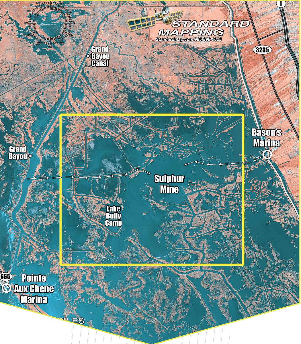
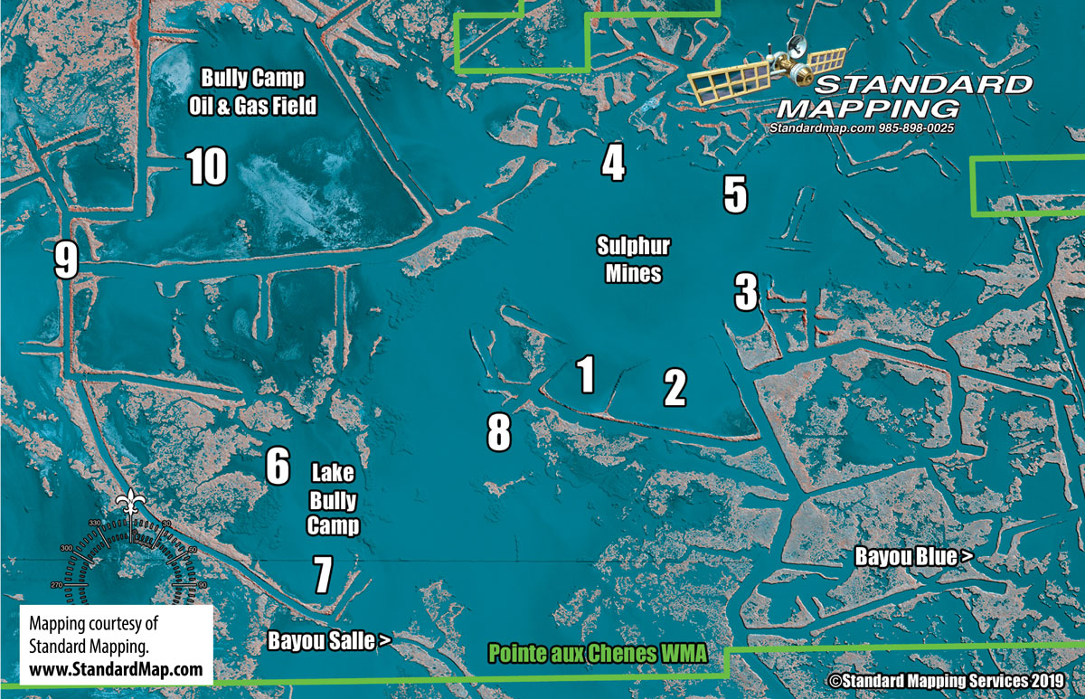 And it is that bouncing around that really makes the Sulphur Mine shine during March. Because it’s a relatively protected section of marsh, anglers can always find a productive area without having to cross miles of open water to get somewhere. On windy days, Cheramie simply finds a lee shore and fishes. Here are 10 of his favorite spots.
• No. 1: Dam Cove One
(N29 27 13.83 x W90 23 8.10)
What defines this cove are three things that used to be here that are now long gone. Over the last few years, hurricanes have broken apart a long point that extended into the old mine, some islands just inside the eastern levee and shallow flat in the back of the cove. However, the storms may have left better fishing in their wakes.
“I like to come into this cove and start on the levee to the east,” Cheramie explained. “I follow that side to the back and come around, then fish back up the western levee. I make about three different passes at different distances off the bank, and just keep circling around and working out until I find where they’re hanging out.”
It used to be that Cheramie couldn’t fish all the way to the back of the cove because of a shallow flat, but the storms washed all that out and left a hump about 70 feet off the back bank that has a little dip on the other side. Trout like to hang out in both places.
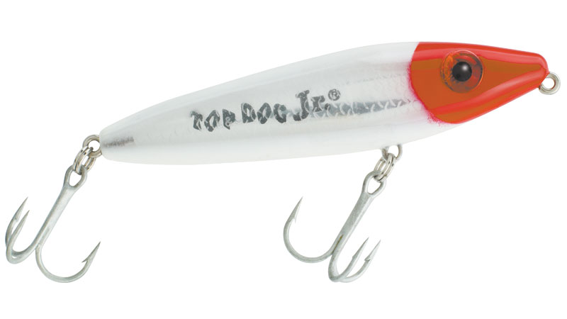
“A south wind is best for fishing here because it’s protected,” Cheramie added. “But I do like a little breeze blowing in here. I like throwing the Top Dog Jr. in here, but you can also bump the purple/chartreuse and black/chartreuse on the bottom.”
• No. 2: Dam Cove Two
(N29 27 13.40 x W90 22 50.34)
The eastern levee of Dam Cove One used to run all the way across what Cheramie calls Dam Cove Two, essentially blocking it off. Erosion has scoured this levee enough that boaters can pass into the cove now, and it offers a good mix of trout and redfish.
“This one’s got some big, shallow flats in the corners to the east and southwest,” Cheramie said. “Some grass grows in those two corners, and it’s more redfish up in them. Some trout, too, but you’ll mainly find them back out in the deeper water closer to the mine.”
During high tide, Cheramie likes to push back into the grass flats and sightfish for cruising redfish. With a southeast wind, the combination of slick, clear water with a mirror surface makes the big bulls easy to spot.
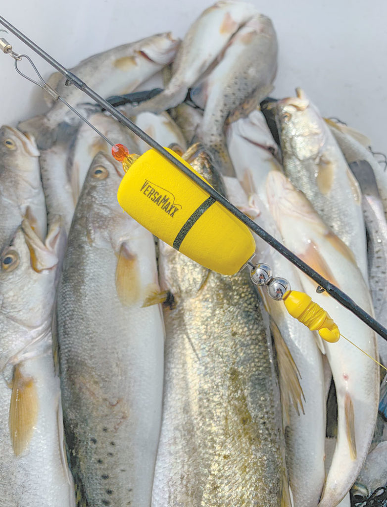
“For the trout, fish around the one leaning power line pole out in the middle toward the mine,” Cheramie said. “There aren’t many oysters in the mine, but that pole is one spot that has them. Fish cocahoes about 2 1/2 feet under a cork. I fish minnows on a p’ain hook so they can swim around naturally.”
• No. 3: Power Line Cove
(N29 27 29.80 x W90 22 33.30)
What Cheramie likes most about this cove is that it is the only one in the mine where the grass starts to grow early. He says it will grow from the back to about 100 yards from the bank. As you enter the cove, look for the point to your right. That is about as far out as the grass grows.
“Trout like to stage out in front of the grass, and those big, lazy specks like to hang out on top of it,” he said. “I like to throw a Top Dog Jr. over the grass, but if they don’t eat on the surface, I’ll switch to bait I call the Ghost (a soft-plastic suspending lure), but you could also throw the soft jerkbaits.”
Redfish tend to get farther back in Power Line Cove, and Cheramie says there is one little cut in the back corner to the right, or south, that attracts most of them. One of Cheramie’s best redfish techniques around the grassy cut is flashing a gold spoon above the grass.
“The good thing about this cove, besides the grass growing early, is that it won’t be matted out on the surface in March,” Cheramie said. “I like to start at the point and just kind of drift across it for trout. The best winds for fishing here would be south, southeast and east.”
• No. 4: Anchor Cove
(N29 28 3.94 x W90 23 6.00)
Cheramie jokingly called this spot Anchor Cove because, “It’s got about four or five of my anchors here and quite a few of other people’s anchors, too.”
A few old pipelines that cross the bottom here are what claims the anchors, but it is the pipeline and surrounding oysters that attract the fish.
“This spot has the most oysters of any spot in the mine,” he said. “You got a couple canals that drain in here, and it’s got good current flow when the water is moving. Trout stack up on top of the oysters and eat the bait pulling out of the cuts.”
Since this is a spot to catch numbers of trout with an occasional big fish or two, Cheramie likes to throw a Cocahoe under a cork for the keepers and a Top Dog Jr. for the wall hangers. And because of the shells on bottom, it’s perfect for bumping a soft plastic.
“This spot is on the northwest side of the mine, so it’s a great place with north or northwest winds,” Cheramie said. “I’ve targeted the wells a lot, but I don’t catch much around them. The pipelines really aren’t that important for trout, but they do get a lot of sheepshead around them.”
• No. 5: Horseshoe Island
(N29 27 54.97 x W90 22 26.75)
Another spot that has been eroded to the point of no longer being visible from the surface, the remains of what Cheramie called Horseshoe Island still attract lots of keeper trout below. The pipelines, oysters and cuts that attracted fish while the islands were visible still attract fish today as long as you can find the subtle hump on your depth finder. It should come up from 5 to 3 feet.
“If you can get on it, it’s a spot that holds a lot of fish,” Cheramie insisted. “There are a couple wood signs on the bank to the northwest, and if you line that up with the point of land to the southeast, you should be close. The only problem here, though, is all the boat traffic coming out of that cut that goes up into Bason’s Marina.”
Since the spot does get so many passing boats, Cheramie explained that the best thing to do is to try to get there early. Once a couple boats anchor and fish the islands, all the passing boats have to navigate around the island. He also favors fishing this spot later in the afternoon after most of the boat traffic has died down.
“The best way to fish this underwater island is with a cork,” Cheramie added. “You can fish plastics or minnows, but they like it under a cork here. If I’m after a wall hanger, I’ll try topwater. It will also get a big pile of reds on it every now and then.”
• No. 6: Eight Pound Cove
(N29 26 51.54 x W90 24 26.45)
The Sulphur Mine can get jammed up with boats when the fish are biting, so Cheramie has a few close spots that he can run to and fish to get out of the crowd. The first of these spots is a nondescript cove in the back of Bully Camp Lake where Cheramie and his customers have landed and lost many giant trout.
“Not a lot of trout come in here, but the ones that do come in are really nice,” he said. “They like to stack up right at the mouth of this cove, but they’ll also get back there in really shallow water. It grasses up in here, and the water gets really clear — almost like an aquarium — so you’ve got to be really quiet coming in.”
If the tide is high, Cheramie likes to throw plastics or minnows under corks, but he admits he has trouble putting down his topwater in this cove because of all the big fish he’s caught on it here before. As it gets closer to April, Cheramie says this spot becomes more of a numbers hole.
“Reds come in here, too,” he added. “There is some broken marsh to your left as you go into the cove, and the reds get around that stuff. I fish them with a spoon, and it’s a great spot for sight fishing because the water is so clear. And for some reason, the grass seems to grow best to your right as you go in. Reds like that, too.”
• No. 7: Bully Point
(N29 26 31.03 x W90 24 8.60)
This is the point on your right as you enter Bully Camp Lake from the cut to its southeast. Rather than Bully Point being the spot, it marks the beginning of one of the best redfish banks around the Sulphur Mine. Cheramie likes to start at the point and work his way south toward the broken marsh in the back corner.
“The reds can’t pass it up with all that broken marsh and the grass that grows in here,” said Cheramie. “I like to throw the spoon, me, but you can also catch a lot of reds just bumping the bottom with plastics or throwing a spinnerbait. If I don’t get any bites between the point and the back corner, I just keep fishing around the shore to the west.”
Although it’s better known for redfish, the water behind Bully Point also attracts lots of keeper trout when the juvenile shrimp start showing up. The trout get away from the bank, though, and Cheramie typically catches them out in open water.
“You can start drifting at the point and just work to the far point to the west,” he said. “There are some old islands scattered along that drift line, and the water gets deeper out that way. Throw plastics or minnows under a cork, but you can throw something on top if you hit the right conditions.”
• No. 8: Pole Cut
(N29 27 3.26 x W90 23 30.14)
This spot really shines as long as the water is moving one way or the other. Cheramie really likes it when the water is falling out, thus pulling a lot of water out of the Sulphur Mine. As the water exits the cut, it spreads out and creates all kinds of current lines in the open pond just to the southeast.
“The boat traffic gets a little bad right in the cut,” Cheramie explained, “so you got to catch your fish and wait it out after somebody passes. The key is to not fish just the cut, though. Back off and drift toward the islands to the southwest that would be over your left shoulder if you’re fishing the cut itself.”
Cheramie targets the big schools of shad that work the current lines in the pond, and he says the trout seem to get bigger the closer he gets to the islands. Since the water always seems to be clear here, Cheramie prefers throwing topwaters with silver sides and white bellies.
“You could also throw those little shallow-diving stickbaits with the little bills,” he said. “Anything flashy will work here because the trout are used to eating shad in the clear water. This spot gets really good as the trout start to leave the Sulphur Mine about the middle of April because most of them come right through this cut.”
• No. 9: Four Corners
(N29 27 39.68 x W90 25 15.06)
Cheramie calls the canal that runs from Bayou Blue to the Sulphur Mine April Canal. About a third of the way into the canal past the two dams is an intersection that creates four points. This spot is relatively deep compared to surrounding water, and there are some old pipelines and a bunch of trash on the bottom. The high volume of water that passes here makes it a great spot.
“Trout love to come out in here, but there are a lot of reds and drum, too,” Cheramie said. “They get in here because of all the bait. Like a couple of the other spots, you’ve to fight the boat traffic here, but most people will idle through if they see people catching fish. Every March and April, this canal turns on, and this is one of the best spots along the entire stretch.”
Cheramie likes the northeast corner because of an old pipeline and its quick drop off. As the water moves through, it swirls around this point and creates eddies. But he doesn’t stop after fishing the point. Rather, Cheramie fishes the entire area and the open water between all the points.
“I like to fish the bottom with Carolina-rigged cocaho minnows,” he said. “You could throw a cork if you think the trout want a little noise, but the Carolina rig will catch anything that swims through here. Sometimes you get some on topwater, but not too often.”
• No. 10: Sunken Island Pond
(N29 28 2.02 x W90 24 43.23)
On most updated maps, you won’t see the old island that used to be about 100 yards straight in front of the cut as you enter this pond. However, on some older ones, you’ll see a large area of land that’s just not there anymore. That’s why Cheramie calls this spot Sunken Island Pond.
“Trout and redfish will get in here during March and April,” he said. “I like to troll the banks immediately to your right as you exit the canal that leads into the pond. I like a west wind here, and this is one of my favorite banks to fish on this side of the mine.”
Cheramie says the open water to the right is full of little islands out in the middle that just shift around from year to year. The only thing that might reveal them to you may be a little stick or tuft of grass. Trout stick to the open water, and the redfish can be along the bank or around the little islands.
“I throw a lot of topwaters for trout in here because it’s so shallow,” Cheramie said. “And I catch a lot of fish on minnows under a cork. I throw a spoon on the redfish, but a guy with me a couple years ago smoked the reds by whipping an Exude jerkbait on a 1/8-ounce jighead. You just never know what fish around here are going to bite.”
Contact Capt. T-Man Cheramie at 985-693-6828.

