Pros & cons
This St. Bernard Parish area is one of the prime inshore fishing spots in all of the Louisiana coastal marshes, with many weather-protected fishing locations.
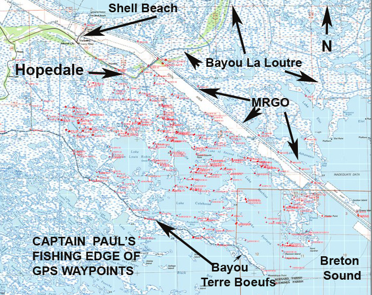
This area is sometimes called the Hopedale Marsh, and is located between the Mississippi River Gulf Outlet (MRGO) and Bayou Terre Boeufs. It can be reached via launches in Delacroix, Hopedale and Shell Beach.
The entire area is crisscrossed with natural bayous, lagoons, bays, lakes and reefs, and is bordered on the east by Breton Sound.
270 waypoints provided
Specks, white trout, reds, flounder, croakers, sheepshead, black drum, tripletail — and catfish and sharks — are all found in various parts of the area.
My Fishing Edge for Hopedale/MRGO to Bayou Terre Boeufs has more than 270 waypoint locations.
I have limited out our catch at many spots, including a point and a large flat lagoon to the northwest at the mouth of Bayous Bernard and Pisana at Lake Coquille, (which is French for Shellfish Lake) at 29°44.9302’N ~ 89°35.0870’W.
This Edge also has waypoints in and around Hopedale Lagoon, one of which is named as Hope 02 at a point in the lagoon located at 29°48.1265’N ~ 89°38.7596’W. Another is located around Lake Amedee by a cove on the east side named as Hope 133 at 29°46.0277’N ~ 89°41.2366’W.,
More of the common hotspots are naturally the mouths and nearby turns throughout the area. It also has a warning waypoint by a sunken tank in the outfall/back levee canal that is north of Lake of Two Trees and northwest of Bayou Malatto listed as DANGER at 29°44.8033’N ~ 89°31.1916’W
Nearer Brenton Sound has the location that was once Raccoon Island, but is now a reef in the area. Waypoint HD EDGE58 is at 29°38.7395’N ~ 89°28.0713’W, and the southern tip of the former island listed as HDEGE59 defines where the island was once located.
In Breton Sound, it features the location of the Five Wells and where the Dope Boat was once located.
Captain Paul’s Fishing Edge of GPS Waypoints has these and many more locations, which were determined using WAS 84 Datum and are stated as degrees, minutes and ten thousandths of minutes. (DDD,MM.mmmm)
As you know, waypoints can now be electronically installed in most GPS units. This feature allows the user to install a great amount of waypoint data in just a few minutes.
Each Edge file has an electronic data file that can be downloaded in to a variety of GPS brand units. All of the EDGE programs are sent as an email attachment. This data download enters all of the Captain Paul’s Waypoints into the unit in a matter of seconds from your computer. To help those of us who are not computer savvy, each download has a general map of the area in 1:100,000 scale, and individual information on each waypoint. These map images cannot be installed in the GPS unit, but offer a location of the waypoints and their descriptions, as well as a READ ME and INSTRUCTIONS file.
Latitude~longitude value of the waypoints is included, and in some instances “How to Fish” the location hints are provided. I began marketing these waypoints as Capt. Paul’s Fishing Edge because I believe they will give the fisherman an advantage in getting to, finding fishing spots, moving around, and getting back from some of the more favorite fishing areas in the state.
How to order
Presently, there are 21 locations for Capt. Paul’s Fishing Edge, including Barataria Bay, Lake Borgne, Hopedale MRGO to Miss Sound, Delacroix to Point a la Hache, Bayou Bienvenue, Port Sulphur, Lake Pontchartrain, Lake Borgne, Calcasieu Lake, Pearl River WMA, Lafitte, Leeville East and Leeville West, Vermillion Bay, Empire-Buras, the Rigolets and the MRGO, Cocodrie ~ Dulac, Bayou Sauvage NWR, Big Branch NWR, the Myrtle Grove area and the Hopedale MRGO to Bayou Terre Boeufs, are covered here.
I always suggest that you have a reliable compass and a map of the area whenever you venture in the outdoors.
In order to order an Edge file, you must have an email address that accepts attachments. All of Capt. Paul’s Fishing Edge files may be found in the Louisiana Sportsman Outdoor Store, located at www.sportsmangear.com.
To visit Capt. Paul’s website, go to www.askcaptainpaul.com/fishingedge. Remember that you must list your brand of GPS unit, your email address and the selected area you plan on fishing. The Edge files are NOT brand name interchangeable, so be sure to make the correct GPS unit selection.
Captain Paul’s Fishing Edge of GPS Waypoints will definitely give you an edge in navigating and fishing the area.
")
