
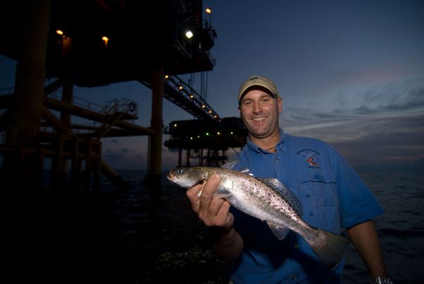
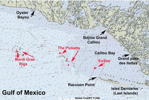
Mardi Gras and EnStar rigs
Dear Capt. Paul:
I have a new camp in Cocodrie, and I’m learning the area. I was hoping to hit some of the shallower rigs for a few lemonfish and perhaps even some snapper.
Do you have the coordinates for the Mardi Gras and EnStar rigs that are supposed to be near the shoreline?
What resources do you have available for us in the way of charts, waypoints, etc?
Thanks a million.
Mike
Capt. Paul’s response:
irst, let’s start with the locations you are asking about: the Mardi Gras and the Enstar rigs. They are the common names for some of the oil and gas platforms that are throughout the area.
Both of these locations are west of the Isles Dernieres (Last Islands) chain of barrier islands that stretches from Timbalier Island bear the Houma Navigation Channel at Navigation Aid (NAVAID) light Green No. 1 in Wine Pass and ends at Raccoon Point on the western end of Raccoon Island.
These “Last Islands” are made up of several barrier islands. They are — from east to west —East Island, Trinity Island, Whiskey Island and Raccoon Island.
Raccoon Island is the western-most of the islands, while Wine Pass on the easternmost tip of East Island at Terrebonne Bay is the eastern end of the chain. These islands are more than 20 miles in length. There are many excellent inshore fishing locations on the land side of islands in the southern part of Lake Pelto, as well as in the surf, weather permitting, on the Gulf side of these islands.
The western-most point of Raccoon Island is named Raccoon Point. It is in the southern part of Caillou Bay. The western-most shoal of Raccoon Point is at or about 29° 03.650’ N. Lat. ~ 90° 57.505’ W. long.
The small structure two miles or so northwest of Raccoon (Coon) Point is the EnStar rig. I believe that it is at or about 29° 04.900 ~ N. Latitude ~ 90° 58. 537’ ~ W. Longitude.
Starting from Raccoon Point and heading west, the bodies of rigs — generally on the same line — after you pass the EnStar rig are rigs called the Pickets, Mardi Gras and the Blue Points rigs. All of these locations are outside the federally recognized three-mile state water boundary, with the exception of the EnStar rig.
The Louisiana Department of Wildlife & Fisheries is now claiming state waters extend to 10.357 miles. I mention this, as there are different creel limits in federal and state waters. Be sure that you are aware of the size and creel limits.
On fairly clear days, you can see the Pickets from Coon Point. When you get to the Pickets, you can see the Mardi Gras platform, and from the Mardi Gras rig you can see the Blue Point rigs.
Most all of the “Pickets” rigs are in Ship Shoal Leased block No. 26.
One of the larger platforms is located at or about 29º 06.557’ N. Lat ~ 91º 03.484’ W. Long. From the above location you can see several of the commonly called the other “Pickets” platforms in the area. These rigs are in a rough northwest to south east line. All of these platforms can be viewed on NOAA chart 11356, Isles Dernieres to Point Au Fer.
The other “Last Islands” are shown on NOAA Chart 11357, Timbalier and Terrebonne Bays. NOOA Chart 1116A Leased Blocks Mississippi River to Galveston Bay shows the Offshore Leased Areas and the Leased Blocks within the areas. I strongly recommend you obtain these charts and keep them on board during your trip.
About 7.25 miles to the west of the large “Pickets” platform is a platform that I believe is The Mardi Gras Platform. It is located at or about 29° 07. 502’ N. Latitude ~ 091° 10. 688’ W. Longitude in the northwest part of Ship Shoal Leased Block 33.
Farther to the southwest, about another 7.6 miles, is a group of platforms that I believe anglers call the Point Blue rigs. The larger platform in the rough center of an irregular oval is at or about 29° 05.598’ N. Latitude ~ 91° 16.989’ W. Longitude.
While I have listed only one platform for these sites, there are actually many platforms around that position. Don’t think that you should only fish the listed coordinates. Any and all of these companion platforms can be real fish producers. They all are in between 6 and 9 feet of water.
Getting there can be a little tricky, as the most direct route by boat would be to use the inland waters of Bayou Grand Caillou on the western side of the Cocodrie to Caillou Bay. Raccoon Point on Last Islands is at a bearing of 187°(Mag) at a distance of 7.25 miles from lands end where Bayou Grand Caillou enters Caillou Bay.
The aforementioned locations can be reached from the shore line where BAYOU GRAND CAILLOU enters the Gulf of Mexico (29° 10.069’ N. Latitude ~ 90° 56.772’ ~ W. Longitude) and many other points along the coastline or from Raccoon Point heading almost due west.
One route from Cocodrie would be about 28 miles just to get to Raccoon Point on the Isles Dernieres. This route via Bayou Petit Caillou to Sainte Elaine to Bodwin Cutoff to Caillou Boca to Raccoon Point. It traverses a lot of open water.
Another route would simply follow Bayou Grand Caillou to the Caillou Bay by the Gulf. It is simpler saying than doing, as parts of the bayou have eroded beyond recognition as it meanders to the south west from Dulac. So be sure that you get a very good map of the area and even enlist the help of the launch operators on the proper course in the bayou to get to Caillou Bay. This trip is about 25 miles to the Gulf most all of which is mainly in the bayou.
Yes, there are other routes that would get you there from the launch areas, but you should at least consider these as a basis for a definitive route that would best suit your vessel and experience.
My positions for the rigs are for the center of the platforms. Unless otherwise specified, all positions are stated as H,DDD,MM.mmm and were determined using WGS 84 DATUM. All Headings/bearings/courses are stated in Magnetic Degrees.
Capt. Paul