Barrier island disappearing before our eyes
Dear Capt. Paul:
I’m trying to locate the coordinates for Freemason Island.
Har11
Capt. Paul’s response:
Freemason Island is one of the southernmost of the islands west of the Chandeleur Islands chain. The island is composed of sand and shell fragments from numerous mollusk species common to the area. It is a favorite fishing spot for recreational anglers.
Freemason Island is west of the Chandeleur Islands in the Chandeleur Sound. It is about 8 miles west of one part of the Chandeleur chain, and is about 8 miles WSW, 227 degrees Magnetic from the North Islands. It is between the southern part of the Chandeleur Island barrier chain and Point Chicot. It is about 17.3 miles at a bearing of 74 degrees (magnetic) from the Point Chicot Green No. 1 marker/light.
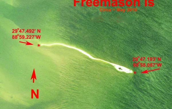
The present Freemason Island is configured in a banana-shaped island that has very little vegetation. The only vegetation is by the east end; it looks like it is a small clump of mangroves. It presently is about 1.25 miles long in a west-east direction.
NOAA Marine Chart 11363 of The Chandeleur Sound indicates that the island is now classified as a shoal, but aerial photo maps show the current island as a sliver of sand above the water. Many days the island is awash with high tides or strong winds.
I keep referring to the current Freemason Island, as the original Freemason Island has migrated to the south west and is now about 2,500 feet to the southwest of where it was before Katrina.
The east point of the present island is at or about 29° 47.193’ N ~ 88°58.086’W. The western most part of the island is now at or about 29°47.491’N ~ 88° 59.227’W.
Freemason Island was at one time in the shape of a reversed C about 2.5 miles in length, mainly in a north to south direction. The northernmost point was at or about 29° 48.342’ N. Lat. ~ 88° 58.823’ W. Long. The southernmost tip was at or about 29° 47.181’ N. Lat. ~ 88° 58.872’ W. long. I mention this because the charts indicate that the water depths around the present Freemason Island vary between 10 and 2 feet. The shallow water evidently is where the island was once located, and should be locations that hold fish.
Before you try to navigate to Freemason Island, be sure that you get up-to-date, official NOAA Marine Charts of the area. Depending on your launch point, it looks like you will need NOAA charts No. 11363, Chandeleur Island; No. 11361, Miss. River Delta; 11371 Lake Borgne and Approaches; and possibly No. 11373, Mississippi Sound and Approaches.
All of these approaches to Freemason Island are littered with many, many large and small oil and gas platforms, as well as numerous wrecks throughout the area. Use caution in the area, as the charts show numerous shoals throughout the entire Chandeleur Island chain.
Using the remnants of Freemason Island as the face of a clock that is about 1.5 miles in diameter,and beginning at the 12 o’clock position, there is a wreck indicated at or about 29°48.403’ N ~ 088° 58.922’ W.
At about the 1 o’clock position another wreck is at or about 29° 48.212 N ~ 088° 58. 386‘ W.
Continuing in a clockwise direction to the 4 o’clock position there is another one at or about 29° 47. 614’ N ~ 088° 58.386’ ~ W.
At the 5 o’ clock position yet another wreck can be found at or about 29° 47. 337’ N ~ 088° 58.733’ W.
At the 7 o’clock area although a little farther from the center yields a wreck at or about 29° 47. 381’ N ~ 088° 59.707’ W.
Again continuing around the imaginary face to the 11 o’clock position you should find one at or about 29° 48.524’ N ~ 088° 59. 627’ W.
These wrecks are listed as having a Position Approximate on the current charts. Any or all of them should offer cover for fish in the area.
You can access Freemason Island, or what is left of it, from Venice by the way of the canal at the end of Baptiste Collette in Breton Sound, which is about 33 miles at 37 degrees Magnetic; from Hopedale via the Old MRGO to Gardner Island then to the Island, about 26 miles at 74 degrees magnetic, and from the Waveland/Bay St. Louis in Mississippi which is about 42 miles at 152 degrees magnetic.
One of the larger shoals that I call FREEMASON SHOAL is located to the North East of the Island. The rough center of this oval shoal is at or about 29° 48.670´ N LAT ~ 088° 57.393´ W LONG. The charts show water immediately around this shoal as between 1 and 2 feet.
Get a current version of NOAA chart 11363 if you want to see the remnants of the island as shown on the chart. USGS Topographical map titled Freemason Island will give you a decent rendition of how the island once looked. If you want to actually see the island, you better hurry as it is slowly disappearing.
Unless otherwise specified, all positions are stated as H,DDD,MM.mmm and were determined using WGS 84 DATUM. All Headings/bearings/courses are stated in statute miles and Magnetic Degrees.
Capt. Paul
Reader comment from LouisianaSportsman.com user Admiral Rabbit
…if Capt. Paul navigated for Amelia (Earhart) she would probably still be here today…
Freemason was beautiful in ’59. There was an old couple that lived on a barge, who’s black coffee would make a spoon stand up…
We can still feel the skimming of the floats in a Cessna landing in the horseshoe… cheers to’ya Capt. Paul.