Can a GPS track or predict the direction of a hurricane? For that, the answer is a resounding no, but a GPS receiver can be a very valuable tool in an emergency.
Don’t just consider your GPS as a hunting or fishing tool. It is a very valuable item when traveling the highways and byways of our nation.
Let me tell you how a GPS unit helped me elude some of the nightmare traffic jams that the Hurricane Ivan evacuation caused.
My wife and I live on the water in the Slidell area. When we noted that category 4 Ivan was bearing toward Southeast Louisiana, we decided it was prudent on our part to evacuate our home.
Communities in St. Bernard, Plaquemines, St. Tammany, St. Charles and New Orleans were advised to evacuate. In addition, other states to our east had already ordered an evacuation.
The day before the recommended evacuation, Lake Pontchartrain waters were already nearing the top of our concrete bulkhead.
As a young law-enforcement officer, I had worked during Hurricanes Betsy and Camille in the 1960s and numerous others since. I had seen what a storm of Ivan’s magnitude could do to a community.
My wife and I were flooded out of our home in New Orleans during Betsy, and were without electrical power and water for weeks. I knew what could happen if Ivan delivered a direct hit to our area.
I had seen such damage first-hand, had waded though flood waters, had helped repair some homes and tried to comfort some of the less fortunate. I saw humanity at its best during those times, but I also saw some of humanity’s worst.
I saw complete devastation in some areas. I was assigned to deliver supplies to shelters in the area where hundreds were living on cots and blankets for weeks. People were without work and, of course, without pay for months. There was no gasoline, and cold drinks were non-existent. All water had to be boiled.
Most grocery stores just opened their doors and gave food and whatever else they had to those in need. I even had to escort and guard ice and bread trucks that were making free deliveries to neighborhoods.
It was a miserable experience, but I learned a lot from it. I did not want to have my family endure such a calamity first-hand again.
My lifelong friend and neighbor, Bob Young, and his wife had invited my wife and me and our daughter’s family to accompany him to his “Green Acres” hunting camp in Mississippi. Bob is also a retired law-enforcement officer, and had worked through these same hurricanes.
Although Bob calls it a hunting camp, Green Acres is actually a rural home on 80 acres near the Homochitto National Forest in Brookhaven. The house has electricity, air conditioning, running water and even TV. A lot of people would be proud to call his Green Acres their permanent home.
We were fortunate. We had a place to go. So we decided to take advantage of the offer and leave our home and head for the camp. Bob and his wife had already decided to leave for the camp. We would follow as soon as my daughter arrived with her family.
Emergency planners were suggesting that those evacuating the area go to the west and northwest for safety. As we planned our trip, I noted that most of the interstates highways were designated as Hurricane Evacuation Routes. I-10, I-12 and I-55 were the interstates of choice for those leaving Southeast Louisiana.
As a matter of safety, in addition to my standard hurricane evacuation items, I included my GPS unit, extra batteries and some maps of several of the adjoining states. I had previously marked several of the major highway intersections along the standard highway route to the camp as waypoints, and had listed my friend’s camp as the final destination. I had then loaded them into my Garmin GPS as a route.
When news reports from radio and TV indicated that some of these interstates were already congested with bumper-to-bumper traffic, I realized that it would be a long drive, time wise, to get to our destination.
Normally when going to the hunting camp, we would use I-12 and I-55 for most of the route. But these arteries were already clogged with people leaving the Louisiana, Alabama Mississippi and Florida coastal areas. News reports indicated that delays were being experienced all over the area.
That meant we had to travel in the same direction as more than one million other people who were also evacuating the area.
Some of the news reports indicated that several people were already on the road over five and six hours, and had not yet reached Baton Rouge from Metairie. I came to the realization that the “standard route” was NOT the way to go.
I quickly reprogrammed a new waypoint route to avoid the interstates and utilize the state, parish and county roads. Our caravan then began our journey.
Although we were forced to take some of the interstates for a distance, we made extensive use of back roads using the internal mapping in the GPS and the paper state highway maps.
We kept in touch with each other via cell phones whenever our signals could get through and, most important, by using hand-held FRS radios.
Once on these roads, our speed accelerated from the 2 to 5 m.p.h. crawl on the interstate to a breezy 50 m.p.h on these secondary roads.
Yes, we had to navigate through small towns, and there were traffic lights controlling some of these locations, but by far the trip had considerable less delay and certainly a lot less stress.
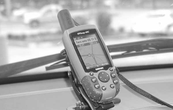
Armed with my Garmin GPSMAP 60C, which was loaded with Garmin’s MapSource Topo US and their City Select mapping software, I had auto-routing, turn-by-turn directions and audio alerts along highways, city streets or trails. I was able to skirt the massive traffic jams.
The MapSend City Select software has turn-by-turn street guidance of U.S. highways, streets and cities. It was flawless during the entire trip. I had the GPS unit operating from a vehicle mount and connected to the vehicle’s 12-volt supply via Garmin’s 12-volt remote power cable. This enabled me to use the electrical power of my vehicle and not have to rely on the internal batteries as well as providing my wife, my navigator, with a stable platform for viewing the GPS screens.
Whereas the normal highway map only showed these towns as a dot on the map, the internal GPS mapping software depicted the small towns and their streets in great detail. The added detail aided us in choosing the correct route through the streets of these small cities.
One of the biggest features in the GPS unit was the pre-programmed “Points of Interest” (POI) waypoints. These POI locations showed locations of various services. It indicated the type of service, the name, address, telephone number and GPS position of nearby locations such as emergency-care facilities, restaurants, lodging, gas stations and shopping locations, as well as several other “interest” categories. It allowed us to replenish our fuel and grocery supplies whenever needed.
We had a place to stay, but it was nice to know that the lodging POI data gave us information to enable us to call ahead to the Colonial Inn in Columbia, Miss., or to the Franklin Inn in Winnsboro or to any of the thousand other lodging locations that were available in the data to check for vacancies.
A lot of these smaller towns have lodging accommodations, and they are certainly a lot closer to Southeast Louisiana than Houston, Austin, Little Rock and Memphis.
The hand-held GPS unit really performed like a winner. It was a great comfort to know where we were, where there were other facilities available and of course how to get to our destination.
This time we were lucky, very lucky, that Ivan spent its wrath on the Mississippi, Alabama and Florida coastal communities to our east. I am extremely sorry for them, but I am glad it spared us. I know the people in that area will adapt and recover.
In the future, when an evacuation is suggested, you can rest assured I will have my GPS with necessary mapping software along with my other evacuation items at the ready.
GPS expert Capt. Paul Titus will answer your GPS questions on-line at www.lasmag.com.

")
