This hunter doesn’t have a lot of time to scout, so he uses timers to know when to be in the woods.
Capt. Paul:
I would like the coordinates for the locks at Freshwater City in Vermilion Parish.
Thank you, Steven
Capt. Paul’s Response:
The Army Corps of Engineers Vermilion Lock, officially named the Leland Bowman Lock, is located just west of Intracoastal City, at the western end of Highway 333 on the Intracoastal Waterway (ICW). It is on the ICW just west of the junction of the ICW and the Freshwater Bayou Canal. The new lock is just west of the site where the old lock was located. Remnants of the old lock are still there.
There is a U.S. Geological Survey Benchmark marker (AV0999) located on the northeast end of the lock just outside the parking lot for lock personnel. The USGS lists the benchmark as being located at 29 47’ 07.66498” N x 92 12’ 12.90763” W (ddd,mm,ss.ssss) using NAD 83 datum.
This converts to 29 47.128’ N latitude x 92 12.215’ W longitude (ddd,mm.mmm) using WGS 84 datum for your GPS unit.
Dear Capt. Paul:
Please provide me with coordinates for the Horseshoe Reef in Lake Pelto, just north, I believe, of Wine Island.
Ref, Baton Rouge
Capt. Paul’s Response:
The Horseshoe Reef that I know of in the area is farther to the west, by Whiskey Pass near one of the Last Islands (Isles Dernieres).
Isles Dernieres is made up of several barrier islands. They are, from east to west, East Island, Trinity Island, Whiskey Island and Raccoon Island.
Wine Island was a very small island that was between East Island and the Timbalier Islands, and was actually in Terrebonne Bay. It no longer exists. There is still a NOAA tide station designated as Wine Island that is very near where the island was located, but the island was eroded away, as has so much of our coastline.
Current NOAA charts also show shoals in the general area where Wine Island was located. Wine Island Pass is now designated near the easternmost end of East Island. The Horseshoe Reef area is about 12 miles west of this location.
The area that I know of called Horseshoe Reef is located in the northwest part of Trinity Island. It is just east of Whiskey Pass on the Lake Pelto side of the island. The reef is actually located at the opening to a cove that is just east of Whiskey Pass, on the north side of Trinity Island. The mouth of the cove at Horseshoe Reef is at or about 29 03.395’ N lat x 90 44.521’ W long.
Good luck. I heard that the fishing there is very crowded on the weekends.
Dear Capt. Paul:
What is the reliability of Raymarine Value Packs (radar/GPS/depth sounder combo)? I’m concerned about the consequences of one unit failing.
What would you suggest if I’m looking for a radar/GPS combo with seperate depth sounder? I have two cut-outs to fill in my console.
Jack, Luling
Capt. Paul’s Response:
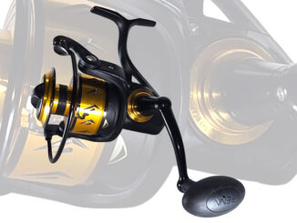
That could work, but Raymarine is top-quality equipment. It is very reliable and has a very good reputation in marine circles. They are presently offering the Raymarine 7-inch Radar, Raychart GPS, Sounder and VHF radio as a reduced-price buy. Raymarine calls the combo their Value Pack.
All of the components are sold as a unit, with a list price savings of over $2,150. The package has a list price of $2,899.99. You should be aware that you will also have to purchase the radar antenna, the VHF antenna and the echo-sounder transducer. The radar antennas are rated at 24-, 48- and 72-mile range. The antenna prices begin at about $ 900, and may go as high as $3850. The transducer ($130 to $270) with mounting block ($70) will also be required.
In addition, the chartplotter will need the proper mapping software. Raychart utilizes C-MAP NT charts ($130-$400).
I have not had the pleasure of operating the Raychart combo unit, but based on other Raymarine equipment, it should be first class. The 7-inch combo screen of the RL70CRC Plus 7 Color Radar/Chartplotter allows the user to select a split screen for viewing or you may select each screen independently. It has the ability to store 1,000 waypoints with 20 routes each with 50 waypoints.
To quote Raymarine, “The hsb Technology that has revolutionized marine navigation — Raytheon pioneered radar technology and on-board navigation instrumentation via hsb with a video buss link, the hsb concept of exchanging radar, chart and sonar data between two displays via a fast, single wire link completely redefined navigation.”
I recommend that you have the package professionally installed.
If one unit in the trio fails, it may affect the others, but again it may not — that all depends on the seriousness of the breakdown. It will, however, deprive you of the services of the other features when you have the unit in the shop for repairs. Check with Raymarine to see what their repair turn-around times may be for the unit.
You can get by without the radar, but the loss of the GPS on the open sea may cause additional difficulties, so I would also carry a small hand-held GPS unit as a backup in the event that some feature of the combo fails and deprives you of its GPS feature. A small hand-held without mapping would do as long as you have your waypoints in a hard copy file while on board. That should be done anyway as sooner or later everything will break, and it makes common sense to have a backup.
Got a GPS question? Ask it at louisianasportsman.com, and Capt. Paul Titus will give you an answer either at the site or here in the magazine.


