With speckled trout and redfish action that is unrivaled in the country, with clouds of ducks filling the skies most winters, with near-shore waters that teem with cobia, dolphin and snapper, Louisiana is rightly dubbed the Sportsman’s Paradise.
But the marsh that serves as the very foundation for those staggering fish and game stocks is disappearing, and in many places it’s totally gone. Unless serious, costly and painful steps are taken within the next five years, the Sportsman’s Paradise will become Paradise Lost.
Believe it or not, the Mississippi River-Gulf Outlet, a.k.a. the MRGO, is longer and wider than the Panama Canal.
The Panama Canal is 50 miles long, stretching across the Isthmus of Panama, connecting the Atlantic Ocean to the Pacific.
In comparison, the MRGO is 76 miles long, and required the removal of 60 million more cubic yards of earth than did the Panama Canal.
But the Panama Canal is an unqualified success. Fourteen thousand vessels per year traverse it, and it earns $400 million annually in tolls alone.
The MRGO? Fewer than five ships per day travel it in any direction, and instead of earning money, it costs anywhere from $13 million to $37 million per year just to keep it dredged.
Perhaps it seemed like a good idea at the time. The U.S. Army Corps of Engineers would dig a navigational channel to directly connect the Gulf of Mexico to the city of New Orleans. The new passage would shorten a ship’s journey to the Crescent City by 40 miles, and provide an economic boon to St. Bernard, the parish most impacted by the project.
The cost? A mere $95 million. The potential benefit? Unlimited, according to a 1957 article appearing in the New Orleans States Item: “…the (MRGO) is a chance for the industrial development of St. Bernard parish as a supplement to the great industrial growth of neighboring Orleans parish.”
It was a promise almost too good to be true — ships, docks, jobs, wharves, business and prosperity. Brochures published in the early 1960s declared the new channel would facilitate “the growth and expansion of the Port of New Orleans, providing new areas for wharves and industrial expansion and relieve the congestion of the existing harbor facilities.”
The brochures said the new channel wouldn’t be so prone to silt up, like the Mississippi did, nor would the water levels seasonally rise and fall as dramatically as did the mighty muddy river. It would be a win-win project.
While the Port touted the logic and economic impact the MRGO project would have on the city, relatively few voices of concern were heard. One 1958 report published by the Department of the Interior, warned that “excavation of the (MRGO) could result in major ecological change with widespread and severe ecological consequences.”
Too bad no one was listening.
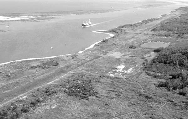
The MRGO certainly provided access. Not just to ships, however, which largely ignored it. It provided access to saltwater. The Gulf of Mexico now had direct access into some of the most productive marshes and wetlands in the entire United States.
In short order, it killed more than 11,000 acres of cypress swamps and turned over 19,000 acres of brackish marsh into saline marsh. Vegetation died. Wildlife died off or disappeared.
The freshwater marshes that once supported over a quarter million wintering ducks and provided an annual fur harvest of over 650,000 animals vanished due to saltwater intrusion.
A recent report jointly sponsored by the LSU Agricultural Center, Sea Grant and Coastal Wetlands and Restoration, and written by Rex Caffey and Brian LeBlanc, said, “The New Orleans District of the U.S. Army Corps of Engineers speculates that the loss of land in the area approaches nearly 3,400 acres of fresh/intermediate marsh. More than 10,300 acres of brackish marsh, 4,200 acres of saline marsh and 1,500 acres of cypress swamps and levee forests have been destroyed or severely altered.”
And the damage continues. The saline-rich water continues its deadly encroachment, further worsening an already incredible soil erosion rate. Every 24 minutes, Louisiana loses another acre of land. Nationally, the average beach subsides about 2 feet per year. Here in Louisiana, we lose upwards of 35 square miles per year. That’s larger than the size of Manhattan.
Suppose invaders from another country captured a Manhattan-sized piece of America, and every year they captured another same-sized piece of our country. What would be America’s response?
We’d fight with all of our might, all of our resources, all of our ingenuity, and all of our hearts, to defend our land and to reclaim what was lost. We would send our young men and women to fight the invaders and they would respond valiantly, willingly laying down their very lives if necessary.
The fact is Louisiana is losing at least that much ground to erosion and subsidence every year, and no real response has been forthcoming from the state or from Washington.
However, many of the citizens and government of St. Bernard Parish have consistently voiced their concerns about the channel, the erosion of their parish, and the direct access the MRGO has provided for tropical storm surges and hurricanes, giving them an unimpeded superhighway from the Gulf into the city of New Orleans.
Their concerns are not without cause. An article in the October 2001 issue of the Scientific American warned that a worst-case hurricane impact could swamp the entire city of New Orleans under 20 feet of water, killing thousands of people. The areas projected to be most impacted? St. Bernard, Orleans and Plaquemines.
Currently, there are increasing calls for something to be done about the MRGO. Recently, the Technical Committee of the Coastal Wetland Planning Preservation and Restoration Act (CWPPRA) listed the closure of the MRGO as among the top strategies for restoring Louisiana’s coast.
And why not? The economic boon to the area it traverses never materialized. The cost per ship to sustain it averages over $13,000, and the whole project has finally come to be recognized for what it is, a major environmental disaster.
The New Orleans District of the Corps of Engineers is currently involved in a $2 million study re-evaluating the economic viability of maintaining the current waterway as is, or modifying it. If the shipping industry believes barge and ship traffic can be accommodated elsewhere, and the study recommends modifications and Congress agrees, the channel could gradually be closed to deep-draft vessels, while remaining open to commercial fishermen and recreational boaters, and any vessel drawing less than 12 feet of water.
Thus, it wouldn’t be a complete closure of the MRGO, but rather the waterway would simply be allowed to gradually silt in until it was about 12 feet deep.
Other proposals include the installation of floodgates, weirs, locks and sills along the channel to reduce saltwater intrusion into the marsh and to suppress potential storm surges.
Not only is a real closure not under consideration, but the corps is not likely to undertake even a partial closure for at least another 10 years, when the expansion of the Inner Harbor Navigation Canal should be completed. Most believe even that time frame is optimistic, considering the continual delays in the construction of the Inner Harbor Navigational Canal.
Relatively little is being done to address the continual land loss directly caused by the channel. Though few ships actually use the MRGO, their wake alone accounts for the loss of at least 15 feet of shoreline per year.
Edmund Russo Jr., corps operations director for the MRGO, said concrete erosion-control mattresses have recently been installed along the south side of the MRGO in the area between Shell Beach and Hopedale to prevent further degradation of the shoreline, and those appear to be helping.
A paper presented by Sherwood “Woody” Gagliano at the Mississippi River-Gulf Outlet meeting at the University of New Orleans in 1999 begins with this introduction, and sums up the present situation.
“The Mississippi River-Gulf Outlet, since its construction in 1965 as an alternative route for ocean going vessels into the Port of New Orleans, has caused increased storm surge vulnerability to developed areas of St. Bernard and Orleans parishes and extensive environmental damage to a vast region. Greatest impacts occur in St. Bernard, Orleans and Plaquemines parishes, in that order. The channel is a serious threat to public safety and an environmental threat to the region.”
")