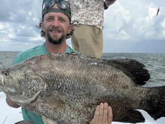
Angler wants to show appreciation to uncle who taught him to fish
Dear Capt. Paul:
I am a native of Louisiana currently living in Texas. I have a Texas registered 28-foot boat with twin 300-horsepower Verados with joystick steering.
I want to tow the boat to Venice to take my uncle fishing offshore for tuna. I’m looking for Thunder Horse, Diana and Hoover coordinates, if you have them.
I am repaying my uncle for teaching me to fish and taking me whenever I wanted to go. I am familiar with Vermilion Bay and South Marsh Island but not with the Mississippi Delta. Can you suggest a marina in Venice to launch and provide caution for navigating the Mississippi passes?
I will mark my location as I leave whatever pass you direct me through (I have a pair of Garmin 7612XSVs) on my way out so I can return to same location.
Thank you in advance,
Gentle Rain
Capt. Paul’s response:
Unless you are going eastward in the Gulf from Venice, you would be using Southwest Pass. It is the main ship channel of the Mississippi River. Use caution, as you will encounter sea-going vessels coming and leaving the area. Give them a clear berth, and you should not be anchored when they pass.
There are two main marinas in Venice that should be able to accommodate your boat and trip.
Check out these:
• Cypress Cove Marina — 226 Cypress Cove, Venice, La.; 504-534-9289
• Venice Marina — 237 Sports Marina, Venice, La.; 504-534-9357
I am not sure what you mean by the Hoover and Diana platforms, but the Hoover Diana fields are located in the Gulf of Mexico 160 miles south of Galveston.
Diana covers several lease blocks but is largely contained within East Breaks blocks 945 and 989 (also covering EB 946 and EB 988).
Hoover is located in the Alaminos Canyon blocks 25 and 26.
It would be very difficult to travel from Venice, La., to this area; Galveston would be your launch point.
Although you did not specifically ask for these platforms, I thought that you might be interested in information for some of the platforms when using the Venice area as a launch point.
Please use this information as a general guide to these locations, as I cannot guarantee that the information is 100 percent. Some of the platforms might have been moved due to the recent trends in the offshore oil business.
With that, my information for the platforms are:
• Bullwinkle (Shell Platform GC-65 A) — located in Green Canyon Leased Block 65 at or about 27° 53.068’ N. latitude ~ 90° 54.155’ W. longitude. That puts it about 114 Miles at a bearing of 232 degrees magnetic from the entrance of the Southwest Pass.
• Brutus — This Shell platform is in Green Canyon Block 158 at or about 27° 47.742’ N~90° 38.824’ W.
• Genesis — in Green Canyon Leased Block 205 at or about 27° 46.761’ N~90° 31.093’ W.
• Mars (Shell-MC-807-A) — in Mississippi Canyon Leased Block 807 at or about 28°10.171’ N~89° 13.373’ W in more than 2,800 feet of water. It is about 52 miles from Southwest Pass at 166 degrees magnetic and about 57.16 miles at a bearing of 186 degrees magnetic from lands end at South Pass. Mars is about 45.5 miles east of Thunder Horse at a bearing of 269 degrees magnetic.
• Thunder Horse — at or about 28°11.452’ N~ 88° 29.735’W. It is in the southwest corner of Leased Block 778 of the Mississippi Canyon Area.
• Ursa — at or about 28° 09.242’ N 89° 06.213’ W. It is located in Leased block 810 of the Mississippi Canyon Area about 7.4 miles east of the Mars platform.
• Medusa — at or about 28°23.559’ N~ 89°27.210’ W. The Murphy Exploration Company’s Medusa Spar platform is in the northern part of Leased Block 582 of the Mississippi Canyon about 34.7 miles at a 182-degree (magnetic) bearing from the Southwest Pass channel gong buoy Green No. 1. It is about 21.4 miles at a bearing of 318 degrees magnetic from the Mars Platform.
• Lena — in Block 280 of the Mississippi Canyon area at or about 28° 39.775’ N~ 89°09.467’ W. It is about 34 miles NNE (07° Mag) from the Mars platform.
• Typhoon — in Green Canyon Block 237 at or about 27° 43.910’ N~ 91° 06.674’ W.
• Ocean Quest — in Green Canyon Block 199 at or about 27° 45.993’ N~90° 47.927’ W.
• The Devil’s Tower — at or about 28°12.534’ N~088°44.189’ W.
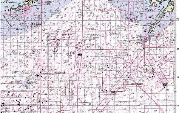
• Midnight Lump — officially named The Sackett Bank, it is at or about 28° 38.122’ N.~89° 33.249’ W. about 20.5 miles from Southwest Pass at a bearing of 201 degrees magnetic and about 35.2 miles at 192 degrees magnetic from the end of the breakwater (29°08.233’ N. Latitude ~ 89° 26. 184’ W. Longitude ) at Tiger Pass.
The location is about 20.14 miles from the Southwest Pass of the Mississippi river at a position near the light house (near land’s end) at a bearing of 202° (Mag), it is also about 19.36 miles at a bearing of 203° (Mag) from the GREEN #1 GONG buoy in the lower part of the SW channel.
I suggest that you first consider NOAA Marine Chart 1115A — Leased Blocks Cape St. George to the Mouth of the Mississippi River. This chart will have the leased blocks in the area of your concern.
Unfortunately, the chart only covers the eastern part of the Mississippi Canyon Leased Area off the mouth of the Mississippi River. The companion chart to the west is Chart 1116-A — Leased Blocks MS River to Galveston Bay. These two charts will give you all of the offshore leased block areas from the Florida panhandle to Galveston Bay.
Any authorized agent for NOAA can order or print these charts for you. Bew sure to get the most current issue of these charts.
These charts, however, are in a scale of 1:456394, which is not suited for navigating the channels or the river, but will get you to the leased blocks. For a better view of the access channels select a chart with at least 1:80000 scale.
These leased-block charts show some, if not all, of the platforms in these blocks.
Unless otherwise specified, all positions are stated as H,DDD,MM.mmm and were determined using WGS 84 DATUM.
Capt. Paul

")