
Missing rig could be valuable fishing site
Dear Capt. Paul:
I’m trying to locate a small satellite platform I used to enjoy fishing located in ST63 block. It shows up on my GPS as an icon that was already on my map card; therefore, I never saved it as a waypoint. It’s been removed and I’m unable to locate it by using my sonar. Question is: I’m not sure if it was made into a reef or if it would have been removed all together. Is there any site that would show or have information on recently removed structures as this one? The only thing I’ve got on it is what automatically shows up on the icon on my GPS, which is ‘Murphy-105-6’. Any help would be appreciated.
PREDATOR
Capt. Paul’s response:
lease don’t delete that waypoint. When you get to that location again, use your depth finder and verify that you are over what was the drill hole for the missing rig. Usually the area around a platform will have some debris in the area. Keep that icon on your screen, and when there again mark it as a redefined and verified waypoint.
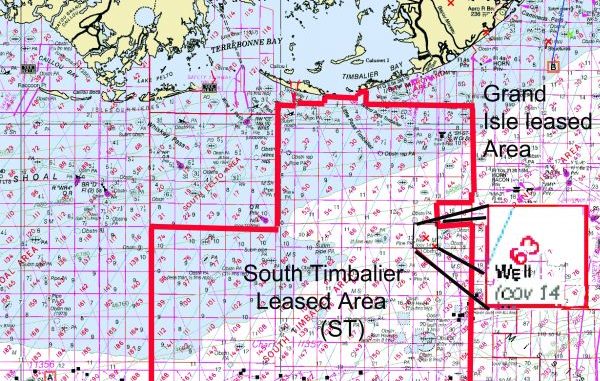
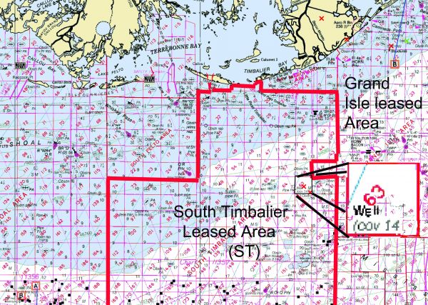
My charts show that there was a well in the South Timbalier (ST) leased block No. 63 that is now covered up to a depth of 85 feet below the surface. It is a very valuable waypoint that many other anglers may not have.
I have this removed platform, cleared to a depth of 85 feet from the surface in water that varies from 84 to 89 feet at a position of 28° 48.460’N ~ 090° 13.194’ W using WGS 84 Datum.
That means that there could still be some well debris at and around the site to a height of 4 to 6 feet off of the bottom. This structure could be an invaluable fishing location.
It is located in Leased Block 63 of the South Timbalier Leased block at about 19 1/2 miles from mouth of Belle Pass at a bearing of 170 degrees magnetic. I suggest that you also use your depth finder at this site to locate any of the debris that may still be in the area and fish around it.
Verify this description and position with what you have in your unit. Use them both to your advantage.
This site is one of 21 wells that feeds a main oil-gas production platform located to the southeast at or about 28°47.610’N Latitude~090°12.155’ W longitude. This platform is about 1 1/2 miles away to the southeast at a bearing of 133 degrees magnetic. The platform is at a 4 o’clock position in an oval that extends to the west and north west for about 2.8 miles.
There are underwater pipelines connecting all of these wells in the oval to the aforementioned main platform, and appear to be spokes in a wheel.
These underwater pipelines are sometimes a productive location, as they usually produce a throbbing sound in the water that attracts certain species of fish.
All of these locations are shown on NOAA Chart 11367, Timbalier and Terrebonne Bays and on Chart 1116A Leased Blocks Mississippi River to Galveston Bay. There is a companion chart (1115a) for areas east of the Mississippi River. I strongly recommend that you obtain both of these charts and keep them onboard during your trip.
The Leased Block Chart is a very valuable planning tool, and should be carried aboard your rig when you are fishing offshore. The scale of the chart, however, is in 1: 458,596 scale. A scale that should not be used for navigation in the coastal marshes. That said, the chart does show all of the U.S. Bureau of Safety and Environmental Enforcement (formally called the Mineral management Services) leased areas and the leased blocks in those areas.
Now for the main part of your question concerning the “how To ght” additional information on the platforms in the federal offshore waters.
The U.S. Bureau of Safety and Environmental Enforcement (BSEE ) is the official government service that authorizes records and tracks all offshore well sites. They assign offshore leased areas and designate certain blocks within these main areas. They publish the data and offer a way to search for particular data at their site.
The BSEE site offers the option of doing an online query or securing a document of all of the data as an Acrobat PDF file.
The query route requires that you enter the leased block code and the leased block number if you know it, and it will retrieve all to the data pertaining to that leased block. Entering only the leased area will give you all of the platforms in all of the blocks in the area. Be sure to check the box just to the left of the information requested.
The online query site is located at www.data.bsee.gov/homepg/data_center/platform/platform/master.asp.
And the PDF download is located at www.data.bsee.gov/homepg/pubinfo/repcat/platform/pdf/3060.pdf
I download the PDF file, print it and keep it onboard as a backup. I do my research from the query site.
The NOAA chart NO. 1116a indicates the leased blocks and their code designation. Simply find a leased block area and the block number, and the site will indicate all of the wells and production platforms in the search.
In doing a search request you will find that the data is recorded and listed is using NAD 27 datum, that is “datum” not data, and is listed in decimal degrees (DDD.ddddddd). To convert it to whatever datum and position format you are using in your GPS unit, you can simply change the datum setting in your unit to NAD 27 and the position format or “location units” to the H, DDD.dddddd setting, enter the positions and then change the settings back to whatever datum and position format you normally use. The GPS unit will do the conversion for you.
The difference between the listed NAD 27 datum at the BSEE site and the currently used datum of WGS 84 can amount to a position change of over 240 feet at this latitude. That is not all that important when going to a large platform that is 100 by 100 yards and six stories high, but it could be critical in finding some of the removed well sites where there is only debris on the seabed.
If you prefer to do it the hard way, there are some programs on the Internet that will compute the figures for you.
The U.S. Army Corps of Engineers has a Web site at www.agc.army.mil/corpscon that lets you download a conversion program to your computer that will do the datum conversion for you.
Then you would have to convert the position location format from decimal degrees to whatever position format you normally use. I have found a conversion program at transition.fcc.gov/mb/audio/bickel/DDDMMSS-decimal.html. It will do the conversion for you or you can mathematically do each position for yourself.
If the first format is in DDD.dddddd (degrees and millionths of a degree) and you want to convert it to DDD,MM,mmm, you would multiply the decimal part of the ddd.dddddd by 60. That would produce a position that would be shown as ddd,mm.mmm (degrees, minutes and thousandths of a minute).
Round off the position to three positions past the decimal point and enter it in your GPS if you are using the DDD,MM.mmm settings.
Keep in touch, and let me know how you make out.
Unless otherwise specified, all positions are stated as degrees, minutes and thousandths of minutes (DDD,MM.mmm) and were determined using WGS 84 datum. All bearings and courses are stated in Magnetic degrees.
Capt. Paul