There’s no need to take a long run to catch all the speckled trout you could ever want.
There are a lot of water-control structures out there that not only block anglers’ access to fishable waters, but also affect the ability of fish and shrimp to get to important nursery and foraging areas. Spotted seatrout, red drum, black drum, southern flounder, Atlantic croaker, blue crab, brown and white shrimp, and a host of other fishery species are called estuarine-dependent because they spend a significant part of their life cycle in estuaries.
Often, these species enter Louisiana’s estuaries at a length between ¼ and ½ inch in size, and they move with the tides to access marsh and shallow-water nursery areas. Water-control structures that block or impede the flow of water into an area also block the ability of these species to get to those areas, and limit the fishery productivity of those areas.
This fishery impact gets worse if a structure that formerly allowed some water movement falls into a state of disrepair and water flow is restricted. Such was the case with one large water-control structure near Hopedale in St. Bernard Parish.
Fortunately, that condition is being addressed with a wetland restoration project that is funded by the Coastal Wetlands Planning, Protection and Restoration Act (CWPPRA) and is presently under construction. The St. Bernard Parish government nominated the project and has been a strong supporter of its implementation.
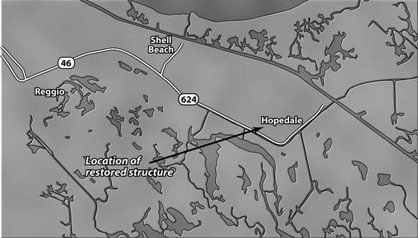
The structure being replaced, visible from Breton Sound Marina, controls the hydrology of more than 3,800 acres of brackish marsh and shallow water bottoms located between State Road 624 and the Mississippi River-Gulf Outlet (MRGO). It was installed in the early 1960s during the construction of the MRGO.
Originally, the structure included three 60-inch flapgated culverts that allowed drainage but prohibited the ingress of higher salinity water (and fishery species) into what was then low-salinity wetlands. The structure was installed by the Corps of Engineers, but it is unclear what agency or entity was given the responsibility for its maintenance.
Eventually, the flapgates fell off, and the culverts partially collapsed.
As suggested by the title, the purpose of CWPPRA is to help protect and restore marsh habitats. CWPPRA projects are not normally developed with the intent to protect and restore fishery productivity.
However, it was perceived by NOAA Fisheries and LDNR that the collapsed culverts might be prohibiting the drainage of rainfall, as well as water that passed over the low-elevation SR 624 during extreme high tides and storm events. Prolonged flooding of brackish marsh can produce conditions that harm the primary plant species present (marshhay cordgrass), which can lead to marsh loss.
Hydrologic modeling and monitoring of water levels was undertaken, and it was learned that water levels in the marsh in question were elevated for up to a month at a time due to poor drainage capabilities. If left in place, further deterioration of the structure was likely, and periods of extended flooding of the marsh were expected to grow longer.
As such, the replacement of the structure was determined to be warranted and necessary. It is a side benefit to CWPPRA that project implementation will improve the fishery productivity of the 3,800-acre project area, as well.
The structure being installed will contain three 84-inch diameter sluice gates to allow drainage only (one-way flow), as well as two 2-foot wide by 7-foot deep slots to allow fishery ingress.
Because people’s homes are located around the perimeter of the project area, those slots can be closed in the case of an anticipated storm surge.
Hydrologic modeling results indicate that structure replacement should reduce the longevity of marsh flooding conditions. Specifically, model runs indicate that it would require fewer than five days to return water levels to marsh elevation following a 10-year rain, and similar reductions in flood duration are expected for other types of storm events.
Project implementation began in March, and should be completed later this summer at a cost of approximately $600,000. Evaluations undertaken by the various CWPPRA committees estimate that project implementation will protect more than 130 acres of marsh, as well as increase the coverage of submerged aquatic vegetation (a very productive fishery habitat).
At less than $5,000 per acre of marsh, and considering the benefits to marine fishery production, this is an extremely cost-effective project.
While structure installation will not facilitate fishermen’s access to the project area, it will maintain fishery access to a productive wetland area. In addition, it should help maintain the health of the marsh, also in support of fishery species.
And because the structure will allow for the movement of fish, shrimp and crabs to marsh nursery areas, it will also allow their eventual movement out of the project area into the MRGO and Bayou LaLoutre, where they can be harvested by both recreational and commercial fishermen alike.
")
")