Restricted area worth avoiding
Dear Capt. Paul:
I would like to set waypoints surrounding the LOOP restricted area as to help avoid the big nasty gray boats. Would you have waypoints and the leased blocks in which the LOOP is located that would help mark the area in my GPS?
Doghouse
Capt. Paul’s response:
The Louisiana Offshore Oil Port (LOOP) is a deepwater facility in the Gulf of Mexico south of Port Fourchon. It provides deep-water offloading and temporary storage services for raw petroleum products by tankers that would find it hard to navigate the Mississippi River to load or unload raw petroleum. The anchor areas, the unloading buoys and platforms, and the underwater pipelines that connect them together and to the shoreline, comprise a very restricted marine area.
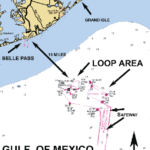
The center of the largest area of the LOOP is located about 27 miles at a bearing of 182° magnetic from Barataria Pass by Grand Isle. There are several other sites that support the actual offshore unloading stations that are in southern Louisiana around the Port Fourchon and Galliano areas. My information is not designed for these sites, but are for the offshore unloading sites.
LOOP has a series of regulations that are listed in Chapter 2 of the U.S. Coast Pilot publication. Additional restrictions are published in the U.S. Coast Guard Official Notice to Mariners that is published weekly. I strongly suggest that you get up-to-date information, as current world events have caused additional regulations to be enacted.
The Notice to Mariners is considered to have the effect of law. It is a publication that every navigator should be familiar with. There is a strict enforcement of these regulations around the LOOP. Even if you are not actually physically arrested, be prepared to be cited and boarded and to have all of your equipment and registrations checked and rechecked.
Describing the LOOP is not an easy task, as the facility consists of the mooring stations, the underwater pipelines and the actual unloading stations. All of these sites are depicted in NOAA Marine Chart 11359_1 LOOP DEEPWATER PORT OF LOUISIANA and in part on chart 11358 Barataria Bay and Approaches. It is also shown on Chart 11366, Approaches to the Mississippi River and on Chart No. 1116A Leased Blocks Miss River to Galveston. I strongly suggest anglers get a current copy of these charts before navigating to the area.
These charts are readily available from any Print on Demand NOAA Chart Dealer. There are several such dealers located through the South Louisiana area. The center of the area of the LOOP near the unloading stations is located about 27 miles at a bearing of 182° magnetic from Barataria Pass or about 18 miles from Belle Pass at a bearing of 137° magnetic.
In viewing these charts, you will note the Safe Fairways for ocean-going vessels arriving from the south, the anchoring positions and the unloading platforms. All of the areas are to be avoided. Super large tankers, ocean going vessels as well as numerous ship support and supply vessels may be maneuvering in this area.
It is nearly impossible to describe the actual boundaries of all of this area without running the actual perimeter and logging in a GPS track of the area. This method may cause undue suspicion to your vessel and trigger a response by the security forces. As noted, there are many irregular offsets, bends and points that are along the borders on all sides of the restricted areas. There are some buoys or other markers at certain points along the boundary line but not at all of the needed points. The visitor has to interpret the imaginary boundary lines shown on the various official marine charts. But that does not absolve you of any liability for being in the restricted area.
For the most part, the restricted LOOP areas are in part or all of the following Grand Isle Leased Block areas: 51, 52, 53, 54, 56, 57, 58, 59, 60, 63, 64, 65, 66 and 67 in about 20 to 25 fathoms of water.
The large northern part of the LOOP facility is where there are unloading platforms and buoys. It occupies about a 12-mile east to west by 6-mile north to south area that resembles an oval on its side in an east/west direction. The approximate center of this northern restricted area is at or about N28°52.681’ x W90°00.090’. That is a 72 square mile area. Yes, I know that it is a big area, but it still is not nearly as big as the restricted bombing area in the Gulf off of the Pensacola naval air station.
Unless otherwise specified, all positions are stated as degrees, minutes and thousandths of minutes (DDD,MM.mmm) and were determined using WGS 84 datum. All bearings and courses are stated in magnetic degrees and statute miles.


