Editor’s Note:
Capt. Paul Titus’ Fishing Edge program is available for 21 areas statewide, and features GPS waypoints for some of the most popular fishing destinations in Louisiana — including spots like Delacroix, Barataria Bay, Lake Pontchartrain, Calcasieu Lake, Vermilion Bay and many more.
To order a specific Edge file, go to Louisiana Sportsman’s Sportsman Store (www.sportsmangear.com) and select the location you’re interested in. Remember, your order must include the brand of your GPS unit, your e-mail address and the selected area. (Edge files are NOT interchangeable, so make sure you enter your correct GPS brand.)
In Capt. Paul’s columns for 2018, he’ll be highlighting one of his Fishing Edge locations each month, along with some of his favorite spots at each site — and he’s getting things started in January with Myrtle Grove.
Dynamite wintertime fishing
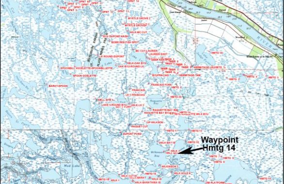
The Myrtle Grove area provides one of the most diverse spots for fishing in the Louisiana coastal marshes. Wintertime fishing is great, but it also offers good fishing year round.
The consistently low winter tides also offer you a bonus of seeing some areas that have deeper holes, as well as recording locations of normally water-covered shallow reefs, islands and peninsulas that dot the landscape.
Myrtle Grove is usually defined by Bayou DuPont on the west and Wilkerson Bayou (not canal) by Lake Hermitage (Perez) on the east. Also, by Myrtle Grove Marina (at or about 29°37.921’N ~ 89°57.1069’W, 161 Marina Road, Port Sulphur, La, 70083, (504) 656-2267) on the north, and upper Barataria Bay on the south. Most of the fishing in this area is located near the main access points around Wilkerson Canal.
There is a “fish from the bank” location that charges a small fee to enjoy the privilege. However, main boating access is via Myrtle Grove Marina.
The marina is located on Marina Road off of La. Highway 23 just past Ironton. (It’s about 36 miles on La. 23 south of the Belle Chasse bridge in Belle Chasse.)
The nearly straight run south from the launch on the canal to the upper reaches of Barataria Bay is only about 14 miles, a short run for today’s boating rigs.
Most of the fishing in the wintertime is in the canals and bayous using a slow jighead on the bottom.
The area also has been known to produce fish under birds in Lake Round, Laurier, Raquette Bay, and on the bottom in the many passes in and around these bays.
Naturally, wintertime fishing almost requires you to fish deeper holes in the area.
The Myrtle Grove Edge covers an area from the Wilkinson canal by Highway 23 to Barataria Bay, and from Bayou Dupont by the Lafitte Pen to West Pointe a la Hache.
It features more than 100 waypoints in and around Baptiste Bay, Lake Hermitage (Perez) along Bayou Du Pont, Wilkinson Bayou with its 15-foot deep hole and Wilkinson Bay, Wilkerson Canal, Bay Chene Fleur and Raquette Bay.
It also has the location where the Four Pilings were located in the upper Barataria Bay area.
Some of my favorite fishing spots included in actual Edge waypoints for the Myrtle Grove area include:
BOB’S REDFISH SPOT:
A small shallow water pond southeast of Bayou Dupont @ 29° 34.896’ N ~ 89°58.2650’W. Approach quietly and fish the mouth of the pond.
WILK 1:
A government reef at the northern part of Barataria Bay @
29°27.3200’N ~ 89°58.2710’W. Look for the four pilings.
WILK HOLE N:
There is a 15-foot hole here (Wilkerson Bayou – Wilkerson Bay) @ 29°27.7080’N ~ 86°54.3163’W.
WELL SITE 5:
A small cut at West End Canal @ 29°31.7196’N ~ 89°59.1064’W. Fish the small cut at the west end of canal.
LAKE LAURIER E:
A small island in the east side of lake@ 29°33.9840’N ~ 89°55.8852’W. Fish the windward side first, then the leeward side. (The western part of the island was once where Deer Range Bayou passed.)
Many spots on the Edge are locations that were once land points or islands that are now submerged — in addition to other visible and key navigation locations.
As always, I suggest that you have a reliable compass and a map whenever you venture outdoors, especially if you’re in an area that you’re not familiar with.
And please remember the coastal marshes are a living estuary that is constantly changing. Some points, islands and bayous may have changed. Use caution whenever you navigate in any of the marsh areas.
Also, do not trespass on any private land and please show other anglers respect while fishing.
All positions noted were determined using WGS84 Datum and stated as degrees and ten thousandths of a minute. (DDD,MM.mmmm)
Captain Paul’s Fishing Edge will definitely give you an edge in navigating and fishing the Myrtle Grove area.
Got a question for the Captain?
Email it to capt@lasmag.com
