It’s hard to define exactly what the Atchafalaya Basin is.
People can’t even agree on the name. Most experts on that sort of thing agree the name “Atchafalaya” is derived from the Choctaw Indian language and interprets as “long river.”
At various times in the past, the river of the Atchafalaya has been spelled Chafalaya, Chiffalie, Chaffalia, Tchafalaya and Atchafa-Laya, amongst others.
Today, the swamp contained within the tall guide levees is most often referred to as the “Spillway” or the “Atchafalaya Basin.”
Technically, both are correct. “Spillway” is most often heard used by people who live on or launch boats from the east side. This includes sportsmen who travel from as far away as Baton Rouge, Denham Springs and Gonzales.
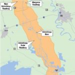
It is, indeed, a spillway, because following the disastrous 1927 Mississippi River flood, Congress authorized the U.S. Army Corps of Engineers to build two massive guide levees running north-south from above Simmesport to Morgan City. The levees are approximately 15 miles apart, and the Atchafalaya River courses the distance approximately halfway between the two levees.
This massive “chute” between the levees is connected to the Mississippi River at its northern end by the Old River Control Structure, a massive system of human-controlled gates that shunt varying amounts of Mississippi River water into the Atchafalaya.
Taking water from the river relieves pressure on the Mississippi River’s levees downstream. Just as importantly, by controlling the amount of water going into the Spillway, humans have prevented the Mississippi River from taking a short-cut to the Gulf of Mexico — which would strand Baton Rouge and New Orleans on what would eventually become a relatively inconsequential bayou the size of Bayou Teche or Bayou Lafourche, both of which were once the main channel of the Mississippi River.
Part of the engineering of the Spillway is the Morganza Floodway, located downriver from the control structure. A large system of gates are located there, immediately parallel to Louisiana Highway 1 and north of the town of Morganza.
In case of extreme flood, when high river water levels threaten either the Mississippi River’s downriver levees or the actual Old River Control Structure itself, the Morganza Floodway gates are opened to divert even larger amounts of water into the Atchafalaya Spillway.
This has happened only twice since the completion of the diversion complex in 1963.
The term “Atchafalaya Basin” is also correct — or at least partially correct — in referring to the great swamp.
Geologists define a basin to be “a synclinal structure, roughly circular in its outcrop pattern, in which beds dip gently toward the center from all directions.”
Leaving aside the scientific jargon, a basin is an area of land that is lower at the center than at the edges, especially one from which water runs down into a river.
Our Basin has higher lands on its east and west sides, with a lower opening to the north and the south.
The high lands on the western side of the Basin are the natural levee ridges of Bayou Teche. On the eastern side, the high lands are the natural levees of the modern Mississippi River and, at the Basin’s lower end, Bayou Lafourche.
Natural levees form along rivers and bayous when flood waters overflow a waterway’s channel and spread out; the sediment load it carries begins to drop out because of reduced current speed.
First to drop out are sands, which because of their large particle size are heavy. Next to drop out are silts, which have intermediate particle sizes.
Clays, which have very small particles, are carried the longest distance from the bayou or river before being deposited.
This process means that, contrary to first-glance logic, the highest ground is immediately along the river and the lowest ground is away from it. The presence of higher natural levees is why our earliest settlers always built their homes and communities on river and bayou banks.
What has been explained above is a geological river basin. The geological basin that the Atchafalaya River runs through is 60 miles wide at the Baton Rouge-to-Opelousas latitude.
But humans have decided to make their own Atchafalaya Basin with their 15-miles-apart levees.
This means that, while the low lands that are geologically still part of the Basin still exist, they are completely cut off from the flood-and-drain cycle that makes the area on the interior of the levees such a prolific fish and crawfish factory.
On the western side of the Spillway, with one major exception (the Lake Fausse Pointe-Dautrieve complex) few mostly wet swamplands are stranded outside the levees.
The situation is different on the eastern side of the spillway, where major areas of wetlands exist between Bayou Grosse Tete and Grand River and the Atchafalaya Spillway levees, running southward through the Lake Verret and Lake Palourde areas.

