Move part of research plan to improve waterfowl habitat, agency says.
Operation Waypoint is a not-for-profit organization that turns donations into free handheld GPS units equipped with Middle Eastern mapping chips for deploying soldiers.
Our military history includes troop deployments with equipment that was incomplete, not yet battle-tested and sometimes darned hard to find. Such was the case with GPS in 1990 when the U.S. Army deployed for Operation Desert Shield. Only 16 of the 24 GPS system satellites were in orbit, and three-dimensional coverage was only available for about 19 hours of each day. The good news was that the early GPS system was accurate to within 60 feet instead of the up-to-eight-mile errors possible with land-based navigation systems of the day.
According to “GPS Goes to War,” an article at www.army.mil/7457, the only GPS units owned by the Army at that time were 500 demonstration receivers. Commercial units were procured in a hurry, but as Desert Shield turned into Desert Storm, only 3,000 of the 40,000 VII Core Army vehicles on the ground carried GPS.
Many troops scrambled to acquire their own handheld GPS units, and a friend who then worked for Magellan Systems told me that the NAV 1000M, his company’s toughest handheld model at the time, was used in search-and-rescue missions, reconnaissance and intelligence-gathering operations, artillery fire direction and support, forward air control and more. They were used by the U.S. Army, Navy, Marine Corps and Air Force units; the Royal Saudi Army; British air and ground forces; French Foreign Legion troops; and Omani and Moroccan ground units.
Seven different GPS units were used in Desert Storm, but the Magellan NAV 1000M and Trimble’s AN/PSN-10 “Slugger” were the most prevalent. GPS proved invaluable beyond combat operations as support units struggled to keep the fast-moving fighting units supplied in an almost featureless sea of sand.
Fast-forward to today, and the GPS system is generations ahead of Desert Storm performance. The least-expensive civilian handheld receivers are tiny in comparison and capable of 10 times better accuracy. Unfortunately, we still have troops on the ground in Iraq and Afghanistan without GPS.
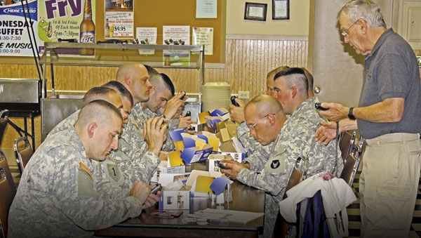
Operation Waypoint, a Minnesota not-for-profit organization, reports that the military only provides one GPS device per unit, and it is usually mounted in a vehicle. If that vehicle is hit or that lone GPS device loses its digital mind, the whole unit is back to map and compass navigation.
Operation Waypoint was started in 2005 by retired educator Ed Meyer after a former student, preparing for deployment to Iraq, contacted him to ask what type of GPS unit would be best for his mission. Meyer contacted a friend at Lowrance, requested three GPS handheld devices, and trained the company commander and two former students to use them.
Shortly after the soldiers arrived in Iraq, while traveling at night, their 24-vehicle convoy took a wrong turn into a dangerous Baghdad neighborhood following the lead truck’s Army-issued GPS unit. Realizing the mistake, the convoy commander called Sgt. Gaylen Heacock, one of the soldiers equipped with a Lowrance device supplied by Meyer. Heacock’s handheld unit determined the correct route and was able to guide the convoy to safety. Upon hearing about this incident, Meyer worked through the St. Augusta American Legion Women’s Auxiliary Post 621 in St. Cloud, Minn., to broaden the idea into a full, not-for-profit program.
“Our goal is to spearhead an even larger movement where communities nationwide can directly support our troops in a very meaningful way,” said Meyer, “I believe that every soldier that feels a GPS would aid them in their mission in the Middle East should have one with them.”
Run completely by dedicated volunteers, Operation Waypoint is committed to increasing the safety of military men and women deploying to the Middle East by providing them with handheld GPS units and mapping cards for Iraq and Afghanistan. The operation has relied heavily on its partnership with Lowrance as well as generous donations from service and social organizations and numerous individuals to fund the effort.
Soldiers are provided with Lowrance Endura Safari handheld, 42-channel receivers with built-in three-axis magnetic compasses. They combine touch-screen operation with simple menus for fast, seamless operation, and are designed to be used one-handed. Their 2,000-waypoint memories have plenty of room to mark areas of safe passage, suspected insurgent buildings, casualty evacuation points and other positions that can be shared with other GPS units or added to satellite maps. Operation Waypoint purchases its units directly from Lowrance, and that company allows the organization to copy its Middle East mapping onto locally purchased blank microSD cards. Each soldier is personally trained on the handheld GPS unit and mapping prior to his or her taking it overseas.
“Each Lowrance GPS and chart card costs $115 after corporate discounts are factored in,” said Meyer, “Unfortunately, there are still times when we can’t purchase enough units. I have even given my personal GPS away because I can’t imagine turning down a brave soldier. The challenge, as with most non-profits, is maintaining enough donations to support the program effectively.”
Operation Waypoint seeks to grow nationally by working with other American Legion Posts and organizations with a goal to provide a handheld GPS to every deployed unit. To get more information, make a donation or learn about other ways to support this organization’s work, visit www.gpsfortroops.org or call (320) 252-6693.

