Will the real one please stand up?
Dear Capt. Paul:
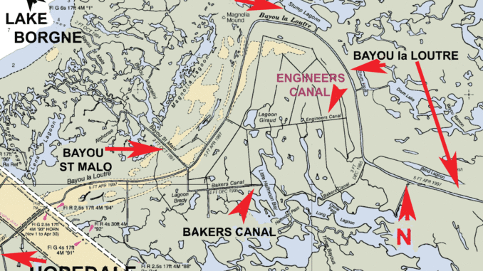
Have you ever heard of a place called “Engineer’s Canal?” Are there coordinates available for this area?
Thanks,
Mark
Capt. Paul’s response:
There are several small canals that are officially named or called Engineers Canal in the South Louisiana marshes. However, the most prominent one is out of Hopedale in the Bayou La Loutre area. By boat, it is about 7 miles from the Breton Sound marina in Hopedale.
This Engineers Canal is in the area where Bayou la Loutre makes a large sweeping U-turn south of Stump Lagoon. Engineers Canal basically runs across the northern part of the enclosed land that is bordered by Bayou la Loutre. It is south of Stump Lagoon, but there is no direct route from Stump Lagoon to the canal and north of Bakers Canal.
Engineers Canal forms a junction with Bayou la Loutre at or about 29°51.304’ x 089° 31.968’. This junction is the westernmost part of Engineers Canal. The canal continues to the southeast for about .5 miles where there is another junction with a canal (29° 51.059’ x 089° 31.516’) that canal runs south-southeast for 1.25 miles to a point where this canal meets Bakers Canal.
Engineers Canal at the junction of the aforementioned canal continues eastward at a bearing of 83° to the very southern part of Lagoon Giraud and then to several other junctions with canals that open to Little Half Moon Bay and other lagoons to the south and north. Engineers Canal ends or begins, depending to your perspective, at a canal that is in a north-south direction. That junction is at or about 29
° 51.301’ x 089° 29.263’. This described north-south canal continues southward into a twisting bayou and canal that “snakes” to the east, ultimately joining Bayou la Loutre.
There are several other canals that are not officially named that are located throughout the area that are in a north-south direction, but the Engineers and Bakers canals are the only two that are in an east-west direction.
This Engineers Canal is north of Bakers Canal, which joins Bayou la Loutre at the junction of Bayou St Malo, Bakers and Bayou la Loutre and rejoins Bayou la Loutre at its eastern end. Bakers Canal offers a shortcut across the northern turn in Bayou la Loutre.
The canals, bays and lagoons are a noted area for fishing when the winds do not allow anglers to fish other waters. I have taken nice catches when the weather and dirty water would not allow us to fish other areas.
However, I would be remiss if I did not offer a stern warning about the area. The bays and lagoons are shallow to begin with, but when a north or northwest wind sweeps the area, it can push most of the existing water out of these flat bays and lagoons.
I was nearly stranded one day when the water nearly disappeared under my boat. We were catching nice trout and a few reds over one of the many oyster reefs in the area in the northern part of Little Halfmoon Bay when the wind changed to the northwest. Within minutes, the oyster reef became visible, and the water began emptying out of the bay. We barely made out by push-poling the boat.
The canals are usually where the deeper water is located in this area, and the junctions with the flat bays and lagoons offer some outstanding fishing locations on a falling tide where the flat bays are emptying into the canals.
My Capt. Paul’s Fishing Edge – Hopedale/MRGO to the Mississippi Sound — has over 10 Edge waypoints in that general area. It has over 300 Edge waypoint in the total area.
The Capt. Paul’s Fishing Edge files are offered exclusively from the Louisiana Sportsman website’s outdoor store.