Dear Capt. Paul:
Do you have the GPS position coordinates for Vermilion Bay and the Boxcar Reef?
– Thanks, WA
Capt. Paul’s response:
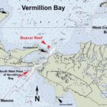
First the easy one. My information is that the Boxcar Reef is in the area of Southwest Point by Southwest Pass of Vermilion Bay.
The reef is roughly aligned in a northwest to southeast position. The northwestern-most corner is at or about 29°37.705’ N. lat ~ 92° 00.432’ W. long.
The southeastern-most end of the reef is at or about 29° 37.360’ N. lat ~ 91°59.799’ W. Long.
It is about eight-tenths of a mile from Southwest Point, light marked Green No. 13 that is marking the Southwest Pass channel at a bearing of 14 degrees (magnetic) in a NNE direction.
The water depth over the reef varies from 3 to 5 feet, where the normal water depth in the area is from 21 just south east of the reef to 8 feet deep on the NW corner.
I suggest you get a copy of NOAA Marine Chart No. 11349 ~Vermilion Bay and Approaches. It indicates this reef, as well as many, many similar reefs in the area.
That was easy, but coordinates for the entire Vermilion Bay will be a little harder.
There are numerous passes, points, reefs and shoals through out the bay. It would be like asking for the position of New Iberia. If you were to give me a specific location, I will gladly try and provide the position coordinates for you.
But there might be an instant solution for your dilemma of getting Vermilion Bay waypoints.
I market a program that is called “Captain Paul’s Fishing Edge of GPS Waypoints” for Vermilion Bay, and it has over 200 waypoints in and around the Vermillion Bay area.
The Captain Paul’s Fishing Edge files are available only on LouisianaSportsman.com.
Captain Paul’s Fishing Edge is a very unique electronic media program that can be downloaded directly into various GPS units from their manufacturer’s mapping program or via several of MyTOPO mapping software programs. This technology saves countless hours of having to manually enter each separate waypoint values into GPS receivers.
I call the program Captain Paul’s Fishing Edge because I believe it will give the fisherman and hunter an advantage in getting to, finding fishing spots, moving around and getting back from some of the more favorite fishing and hunting areas in the state.
The entire procedure of loading over 150-odd waypoints from a typical Captain Paul’s Fishing Edge file takes less than three minutes from the time you view the email file to the time that they are loaded in the GPS receiver.
Presently, I have 21 Captain Paul’s Fishing Edge files. They include Barataria Bay, Lake Borgne, Hopedale-MRGO to the Mississippi Sound, Hopedale-MRGO to Bayou Terre Boeufs, Delacroix to Point a la Hache, Bayou Bienvenue, Port Sulphur, Lake Calcasieu, Lafitte, Lake Pontchartrain, Myrtle Grove-Lake Hermitage, Empire to Buras, Leeville-West, the Pearl River WMA, Vermillion Bay, the Rigolets, Bayou Sauvage NWR, Big Branch NWR, Leeville East areas.
But to have Captain Paul’s Fishing Edge program(s) in your GPS, you must have five items.
First you need a GPS receiver that can accept a computer download; second, your GPS manufacturers mapping program or its waypoint manager software that can transfer data to and from a GPS and a computer; third, you must have a computer with a connecting cable to the GPS unit or data card; fourth, you need a valid e-mail address that accepts attachments; and fifth you must have a Captain Paul’s Fishing Edge file.
Separate program files are designed for Garmin, Magellan and Lowrance GPS receivers and their mapping programs as well as for Maptech Terrain Navigator. These Edge files are not interchangeable.
ALL of the Captain Paul’s Fishing Edge of GPS waypoints are now available at the LouisianaSportsman.com Outdoor Store. It is sent almost instantly upon purchase as a computer download from the Sportsman’s website.
Just log onto www.shopsportsmanstore.com and click on the “Waypoint” link in the right-hand column.
Then simply follow the instructions for ordering from the Louisiana Sportsman’s Shopping Cart. Be sure to select the proper Edge for your brand of GPS unit.
Look the files over, and I am sure you will find that the EDGE waypoints give you a quantum leap head in navigating to and fishing or hunting the area locations.
Get a good map of the area and take note of where the reports on the LouisianaSportsman.com forum are saying the bite is going on. Note the locations on your map, and then start making your plans.
Unless otherwise specified, all positions are stated as H,DDD,MM.mmm and were determined using WGS 84 DATUM. All Headings/bearings/courses are stated in Magnetic Degrees.
– Capt. Paul

