, the boat’s course heading, the water depth and a very accurate time of day.")
A look at the unusual terms, abbreviations and acronyms on your GPS
Looking through an owner’s manual for a new GPS navigation unit, I was surprised at how much the manual assumed I already knew. Some of the terminology was so poorly explained I don’t know how a newcomer to GPS navigation would figure it all out.
Most GPS navigation information is based on the change in your position from one position fix to the next. By looking at where you are and comparing it to where you were at each previous fix, a GPS can calculate your direction of travel.
By timing how long it took you to travel from one fix to the next it can calculate your speed.
Actual GPS navigation is all about waypoints, precise latitude and longitude positions saved in your unit’s memory.
Most units can save waypoints three ways. You can display a lake map or coastal chart and move your unit’s screen cursor to a spot on it and save the cursor’s position as a waypoint. You can also enter the lat/lon coordinates of a location a fishing buddy gave you and save his hot spot as a waypoint. And, you can save the present position of your boat as a waypoint at any time.
I’ve found the last option to be the most-accurate method.
If I want to save the location of a submerged brush pile, for instance, I’ll stop my boat over it and remain stationary for a minute or two to let the GPS position “settle down.” Then, I hit the waypoint save button to put the brush pile in memory.
A unit will automatically assign your new waypoint the next available waypoint number on your waypoint list, but I prefer to name them with a description. “Brushpile3” is more likely to jog my memory than “168” when I want to come back to the spot.
Returning to Brushpile3 is as simple as calling up your waypoint list, selecting Brushpile3 and hitting the Go-To option.
Or you can display the part of an on-screen lake map or chart where Brushpile3 is located, select it with the screen cursor and tell your unit you want to “Go-To” it.
A practical waypoint-use example might be going fishing on a day when the wind is blowing hard out of the north. You launch at a protected ramp on the north side of the lake, and you examine the north shore of your on-screen lake map for waypoints, marking fishing spots that will be out of the wind.
You can visit them at random or set up a route leading you from one to the next, even in darkness or fog.
Keep in mind that, while GPS is perfectly able to guide you to each spot, it can’t see other boats, floating logs or similar hazards. Only an idiot jumps up on plane and roars off blindly in the dark. Take it easy — you want to get you, your fishing buddies and your boat there intact.
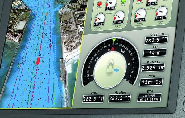
Once you give a GPS a target destination — like our Brushpile3 waypoint — a number of windows appear showing terms and values that aren’t all self-explanatory.
Perhaps the most-important box is marked Bearing or BRG. This is the numeric compass direction to Brushpile3 from your present position. The instant you touch the Go-To button you initiate navigation, and the unit draws a straight line between where you are at that moment and your destination waypoint.
This is your course line. You start out by steering this compass direction and traveling straight down the line toward the waypoint, but if you wander off to the right or left, the BRG number in the box will change because your actual compass bearing to the brush pile has changed.
Your GPS unit has a steering page with a cross-track error indicator to help with this. It shows your course line and your boat’s position in relation to it. If it shows you off course to the right or left, a simple steering correction will put you back on the line.
All you have to do to reach Brushpile3 while burning the least amount of time and fuel is to keep your boat on your course line.
Safe electronic navigation requires a working knowledge of how GPS works. When you tell GPS to guide you to Brushpile3 and it draws your straight course line to the spot, you need to double-check the lake map to make sure that line doesn’t cross a point, island or other hazard.
Some GPS navigation units now have automatic routing features that recognize land masses, dangerously shallow water and other hazards, and set a safe route of waypoints around them. These features save you time and effort and add to your boating safety, but it’s still a good idea to double check the automatic route.
Other boxes of information include the following:
• COG (course over ground) is the direction your boat is actually moving, and it might differ from your bearing if wind or current is pushing your boat sideways as you keep the bow pointed toward the waypoint.
• SOG (speed over ground) is your boat’s speed in relation to a fixed point on earth. This speed indication might be different than one generated by a paddlewheel or pitot tube sensor if current is present because the latter two implements read boat speed in relation to the moving surface of the water. If you are trolling with or against a current, one of these sensors is better for setting your lure speed because it measures your boat’s speed in relation to the water.
SOG makes more sense if you are just running from point A to point B.
• VMG (velocity made good) is the speed at which you are actually approaching your target waypoint, which might not be your boat’s actual speed. If wind and current are pushing you left and right while you struggle toward your destination, VMG accounts for the time you have to waste making steering corrections.
It’s like walking across a field full of cactus to get to a gate on the other side: You might have to take three steps sideways for every step forward. You are trying to get to that gate, but you can’t walk straight to it.
•DTG (distance to go) is the linear distance measurement from your present position to your destination waypoint. This number counts down to zero as we approach and finally arrive Brushpile3.
• TTG (time to go) or ETE (estimated time enroute) is the number of hours and minutes it will take to reach your destination at your present rate of travel. This number also counts down as you approach your target waypoint.
• ETA (estimated time of arrival) is the estimated time of day when you’ll arrive at your destination; it is the current time plus the TTG measurement.
Some units might vary these acronyms slightly, but these are the information fields typically most important to navigation.
Hopefully, they make more sense to you now.

