Navionics’ ‘community edits’ allow user to contribute to marine mapping
Modern electronics are, for me, a simple means of getting from one place to another. Just turn on my old Lowrance, wait for the satellites to relay information and then watch my little boat icon as it moves through the watery terrain I’ve chosen for the day.
Pretty much, that’s it.
I always have my good old Standard Map held to the floor by my feet so I can ensure I’m on course, since my unit is so old it only has the cartoon maps that have no real bearing on the reality of our coastal waters.
I don’t save trails. I don’t delete trails unless they become so crowded I can’t tell where the heck I have just been.
And, yeah, I know I could use the mapping software to plan out routes, and mark and save waypoints.
I don’t do any of that, either.
But my eyes were opened recently to some amazing technological advances that have me dying to up my game.
Navionics SonarChart Live offers the ability not only to navigate with hi-res satellite images (think Google Earth) but actually allow its users to contribute to the accuracy of those maps.
It’s all viewable in realtime through Navionics’ Boating app (available for about $10 in Apple and Android app stores) that connects to compatible GPS units via Wi-Fi.
And those contributions are uploaded to the company’s database — which automatically incorporates the new data into charts downloaded by all users.
Without waiting for a full Navionics upgrade.
“It’s localized data,” Navionics’ Tshombe Moore said. “We get data from the people from that area, and it goes into our database.
“It’s unique data you can’t get anywhere else. It’s realtime.”
I heard this spiel at a recent media event at Bourgeois Charters in Lafitte, but it wasn’t until Moore and I stepped on a boat together that it all clicked.
Moore set up a Wi-Fi adapter in Capt. Taylor’s bilge that allowed the Lowrance HDS system to connect to and talk to the Navionics Boating app on his smartphone.
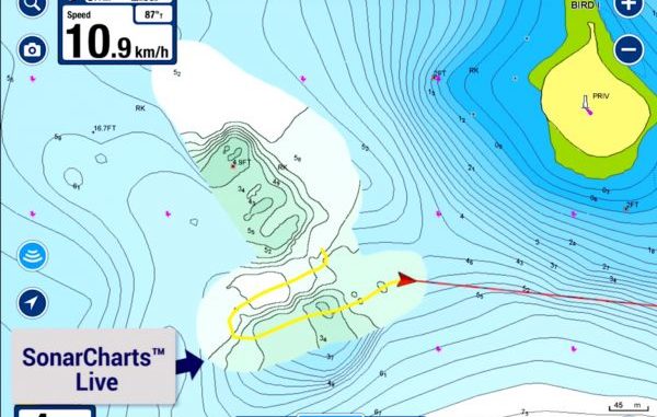
And then Capt. Taylor put the boat on step and I watched in amazement as contour lines were redrawn right there on the app.
“It’s real-time information,” Moore explained. “As long as (the transducer) reads the bottom, it feeds that information into the app.”
It was unbelievable to watch as we ran the canals of Lafitte, but it was when we were skipping across Turtle Bay that the benefits really sunk in.
Moore zoomed out on his phone to see what the Navionics map showed was ahead of the boat, and there was a large green blob a mile away.
I asked what the green indicated, and he said it was a “drying area,” or an area that at low tide would be out of the water.
But Capt. Taylor blasted right through that spot — and new contour lines began popping up on Moore’s app, showing there was 4 to 5 feet of water.
And it happened in realtime.
“The more boats run through this area, the more accurate it will be,” Moore said.
The Navionics system will extrapolate new contour data to reassess nearby contours and give estimates that are tweaked when more app users pass over the water bottom.
Now, if only Capt. Taylor had that new information, the feature would be cool but not useful to anglers at large.
That’s where this deal really shines.
“When you get home, as long as you have the ‘share’ feature of the app turned on, the new data is automatically uploaded to our system,” Moore explained. “Then it’s fed into your unit whenever you update your Navionics card.”
And it’s also shared with any other anglers who insert their Sim cards into their computers.
In other words, if you are using Navionics mapping and you save the Lafitte map to your card, your next trip will feature the new contours Capt. Taylor’s boat discovered.
Amazing.
While Capt. Taylor’s older Lowrance HDS required a Wi-Fi adapter, the new Gen 3 series of electronics come with Wi-Fi built in. So you just connect your phone and run the app.
The system also works with pretty much all other modern electronics on the market, so whether you’re running Garmin, Humminbird, Simrad, etc., you’re set to go.
But all goes one step further: Navionics’ “community edits” allow users to mark wrecks, obstructions, buoys and pretty much anything else. And all that information is added to the database as soon as the app is hooked into the Internet.
“So if you find a rock pile that you know can damage someone’s boat, just get close to it and mark it as a community edit in your app, and when you connect to your home Wi-Fi that will automatically be updated in our system,” Moore said.
But what if you see a community edit in your area, and you discover that rock pile is no longer there?
“You can just click on it, scroll down and delete the community edit,” Moore said.
It is an absolutely fantastic system that can come in handy pretty much wherever you fish and puts you right in the middle of the process of producing updated mapping.
“You have the government that will give you notice-to-mariners (updates). They update them once a year,” Moore said. “With the community edits, that happens all the time.
“You have changes that have been made through out the year way before it happens on the government charts.