Use these techniques to have monster mangroves eating out of your hand.
Weather can kill people in boats and be downright sneaky while doing it. When fishing Lake Tawakoni in East Texas, for instance, I remember how blue northers would slide by just clear of the west side of the lake, like they were going to miss us, and then circle around to come north right over the dam and hit the lake. Storms build big waves quickly, and on many bodies of water you need a head start to beat them back to the launching ramp. More than once I’ve had to duck into protected marinas on Texas and Louisiana lakes to wait out storms that snuck up on me.
Saltwater boaters can usually see a storm coming from a long way off, but can have different weather-related problems. How often have you stayed home because of a scary weather forecast only to find out later that the storms didn’t materialize or stayed clear of the waters you planned to visit? It’s not like you have so many weekends off that you can afford to waste them.
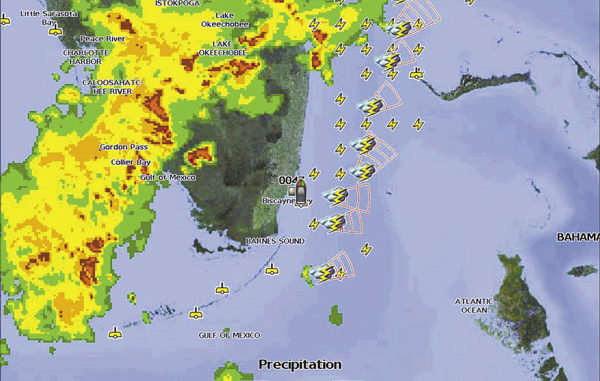
Wouldn’t it be great if you could just walk out to your boat in the driveway, turn on the GPS chart plotter and see exactly how close storms are to your driveway? While we’re wishing, let’s add the ability to see which direction and how fast the storms are moving, where lightning strikes are occurring, what the wind is doing and how intense the rain is in any part of the storm. And, if we are heading out on saltwater, let’s include the ability to read wind data, water temperature and wave height from NOAA buoys. We might as well also add being able to see local weather watches and warnings.
You can do all of this now if the manufacturer of your chart plotter offers a satellite radio antenna module. The two major sources for weather data are SIRIUS and XM satellite radio. Chart plotters made by Furuno, Lowrance, Northstar, Raymarine and Simrad use the SIRIUS service, while plotters made by Garmin and Humminbird use XM radio.
Most of the modules also include the ability to pipe satellite radio’s music, sports, news and talk radio shows right into your boat’s stereo system. Different levels of service with widely varying prices are available from each provider, and not all weather data is available through every plotter-manufacturer’s module. Some coverage stops at the coast and doesn’t include the salt water beyond.
You can find out what is available for your plotter by visiting its manufacturer’s web site, your local dealer or by calling the maker’s customer-service number. For up-to-date details on service plans, visit sirius.com/marineweather or xmwxweather.com/marine.
I have heard charter captains and other serious fishermen compare the weather-tracking capability of radar to that of satellite radio, and skippers who have both onboard favor satellite radio. They say radar is practically line-of-sight, and you can usually see storms without electronic help by the time they appear on radar. In contrast, you can zoom out on a chart plotter to see weather over the whole United States.
They also like the weather warnings and watches, wind information and other data that radar can’t provide. The consensus of opinion seems to be that radar is outstanding for collision avoidance and navigation, but plotters equipped with satellite radio weather data are best for tracking, evaluating and avoiding bad weather.

