
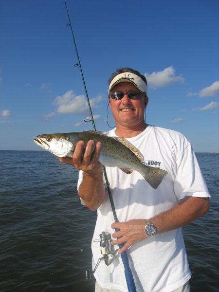
Submerged islands provide good fishing
Dear Capt. Paul:
I know that the Northwest Islands out of Leeville is no longer visible above the water, but I was wondering if you have the GPS coordinates for them?
Thanks in advance,
H
Capt. Paul’s response:
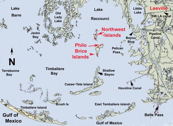
Northwest Islands were located near the center of Lake Raccourci. Notice that I said were located.
These islands were north of Philo Brice Island. Use caution in the area because some maps refer to Philo Brice as Northwest Islands and some do the reverse.
These are actually two different set of islands, most of which are now just underwater.
The Northwest Islands are no longer visible above a normal tide, but some of the remnants can be seen on an abnormal low tide. The water around the island was indicated as being between 3 and 5 feet, so use caution when approaching my positions, as some may only be in a foot or 2 of water.
The old north end of Northwest Islands was on 1989 charts at or about 29°13.020’ N. Latitude ~ 090° 20.776’ W. Longitude. The southern tip of the islands was at or about 29° 11.705’ N. Latitude ~ 090° 20.973’ W. Longitude. It was about .4 of a mile wide and about 1.6 miles long.
There is a platform to the east and the west of where the islands once were. The platform to the east is at or about .75 miles from where the islands were located, and is at or about 29° 12.381’ N. Latitude ~ 090° 29.129’ W. Longitude.
The platform to the west was almost adjacent to the islands and is at or about 29° 12.952’ N. Latitude ~ 090° 21.041’ W. Longitude.
As stated, the islands were between these two oilgas platforms.
The Philo Brice Islands —or the remnants of the Philo Brice Islands — are south of where the Northwest Islands were located.
The north end of the Philo Brice Islands are now shown as a position at or about 29°11.449\’~ N. Latitude ~ 090°20.281’ W. Longitude, and the southern end is shown as 29°11.256’N. Latitude ~ 090° 18.055’~ W. Longitude.
The old ruins on the Philo Brice Island are shown as being at or about 29°11.144\’~ N. Latitude ~ 090°20.746’~ W. Longitude.
NOAA Marine Chart No. 11357 ~ Timbalier and Terrebonne Bays indicates that the Northwest Islands were at or about 6.6 miles at a bearing of 327° (NW) from the Aid to Navigation R-36 (29°07.392’ N latitude ~ 090°17.355’~ W. Longitude) at the end of the Havoline channel in Timbalier Bay and about 3.5 miles north (355 degrees magnetic) from the remnants of Shallow Bayou Island which is located at or about 29° 08.785’ N latitude ~ 090° 20.765’ W. Longitude.
They are also about 4.25 miles at a bearing of 269 degrees from the Private Aid to Navigation marker No. 1 (29°12.589’ N. Latitude ~ 090°16.828’~ W. Longitude) at the mouth of Bayou Blue in Lake Raccourci that leads to Hackberry and Picket Bay and Little Lake.
The plot of where the Northwest Islands were located would also place them at or about 3.2 miles at a bearing of 285 degrees magnetic from Pelican Pass. Remnants of the Pelican Pass islands to the east of the pass were located at 29°11.603’N. Latitude ~ 090°17.964’ W. Longitude and 29°11.255’~ W. Longitude ~ 090°18.055’~ W. Longitude.
When navigating to the Northwest Islands, do not pass up fishing at the aforementioned locations, as well as the numerous small platforms and wellheads to the east of the Northwest Island locations. They too all offer very good fishing locations.
Capt. Paul