
Do you have a favorite fishing area that isn’t mapped as accurately as you’d like? Now you can do it yourself with any Lowrance HDS multifunction unit, including new models with touchscreen control. The neat digital contour map cards we practically take for granted are the result of a lot of work. Map-making companies like Navionics send a special boat equipped with sonar and GPS out to survey a lake, and then process the resulting mountain of geo-referenced soundings into the contour map cards we plug into our units.
The trouble is not every lake and pond is covered by commercial mapping, the contours of sandbars and passes can change with dredging and shifting water levels, and coastal anglers and flats fishermen often see changes engineered by Mother Nature during hurricane season.
The big changes will be caught by the map makers and incorporated into map updates, but smaller changes that affect our fishing success might be missed.
Making digital maps used to require fishermen to connect a sounder and GPS receiver to a computer, and then master a special software program to turn the soundings and coordinates into custom maps. Those of us who are a few volts short of being electronic wizards often found it beyond our ability.
Fortunately, things have changed: Now all you need is a Lowrance HDS sonar/chart plotter and an Internet connection.
You turn on the unit’s standard sonar-logging feature and run a zigzag pattern over the bay, pond, lake or other area of interest while the HDS unit records everything to a memory card.
Then you take the card to your home computer and use a PC application to upload the sonar log file to the new Insight Genesis cloud service. The online service converts your data into a map, and then sends you an email notification that the map is available to view for free online.
You can also download this custom map (for a fee) onto an SD card for use on your HDS unit (or select Lowrance Elite models).
A one-time map download is $19.95, and it includes contours, depth soundings and depth shading that can be viewed on a PC and one registered chart plotter.
Buy a standard annual subscription for $99.95 and you gain the ability to merge multiple uploads into a single map, save maps online for future retrieval and submit up to four hours of sonar data per map instead of the standard two hours. And, you can view your maps on up to four registered chart plotters.
Go all-out for a premium annual subscription ($299.95) and you can also overlay bottom hardness and vegetation outline layers, analyze changes over multiple recordings with trend-analysis tools and use your maps on up to six registered chart plotters.
The Insight Genesis cloud server can provide a convenient and secure location to store trips and maps, and it lets you merge multiple files into a larger map over time to increase the coverage and quality of each map.
A free Insight Genesis Web viewer also lets you review your Broadband Sounder and DownScan Imaging sonar logs, and view their trails and corresponding maps overlaid on a Bing satellite map.
Visit insightstore.lowrance.com/insightgenesis for more information on this neat new tool from Lowrance.
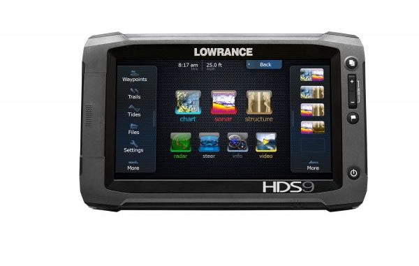
Fishermen and boaters not equipped with a Lowrance HDS unit might consider the newest models in the HDS Generation 2 line — the HDS Gen2 Touch Insight USA.
As you might guess, these new units come with touchscreen displays in 7-, 9- and 12-inch sizes.
Why a touchscreen? You have to use one to fully understand how much faster and easier a touchscreen is to use than key and button controls, but if you have a smart phone, you already know this.
Still, Lowrance has included a few manual buttons for those February days when you are fishing in the rain with gloves on.
Touchscreen models also take up less room. Not needing a full keypad next to your screen means a unit can be smaller and fit where a conventional keypad model with the same sized screen would not.
The new Touch series units not only come with the enhanced computer power and other benefits of the regular Gen2 models, but some feature Lowrance’s Broadband Sounder and StructureScan HD with SideScan and DownScan Imaging built-in.
On the sonar side, a TrackBack feature lets you scroll back through recorded sonar history for review, zoom in on passed-over fish and structure readings for a better look, and then save their locations as waypoints.
Touch models are available with either a 50/200 kHz skimmer transducer for coastal and deepwater use or an 83/200 Skimmer for inland fishing.
If you want to go offshore and look really deep, you can use compatible Airmar in-hull or through-hull transducers with up to 1 kW of power.
Touch units can network with a StructureScan system already on your boat, or they can be ordered with a StructureScan transducer.
A GPS antenna is built into Touch units, and they can also use an external antenna when mounted without a clear view of the sky.
Insight USA inland and coastal cartography come preloaded. A standard SD card slot handles Lowrance Insight HD chart cards, Navionics Platinum Plus, HotMaps Premium, HotMaps Platinum with Freshest Data, and fishing Hot Spots Pro cards. You can even view Lowrance and Navionics mapping data simultaneously.
Both conventional and 3D perspective views are available, depending on the cartography. Touch models are also ready to use optional Lowrance modules like the Broadband Radar, SonicHub marine audio server and LWX-1 Sirius satellite weather/radio receiver.
Suggested retail prices range from $1,299 for the HDS-7M Gen2 Touch Insight USA chart plotter (GPS only) to $3,249 for the flagship HDS-12 Gen2 fishfinder/chart plotter.
Check them out at the new Lowrance Web site at http://www.lowrance.com/en-US/.

")
