Blogger pops the question during fishing trip to West Timbalier Island
Having a good day of fishing usually comes down to one thing: the weather. Whether you’re catching plenty or not, fishing is always fun unless Mother Nature turns against you
By using the help of weather Web sites, those turbulent, windblown seas and deadly lightning can be easily avoided with a few simple clicks.
Over the past few weeks, I’ve made many successful fishing trips that I’ve been posting reports on. There was only one day I wasn’t able to fish at all. That was the night the Harbor Light burned down.
The hourly report at 4 a.m. predicted only a 10 percent chance of rain through noon. Once arriving, however, thunderstorms popped up everywhere before 6 a.m. The hourly report changed to 60 percent all day, with a solid-green radar screen.
Sometimes you get lucky with the weather; other times not so much, though many of my trips this summer have been greatly extended by using weather Web sites.
Harbor Light launch is still open for use. It is still $6, but you’ll need to pay in cash. The fire was started in the kitchen in the middle of the night, and the owners plan to rebuild it. They will set up some fundraisers soon.
Two weekends ago ended up being, by far, the best trip of my summer. The hourly report gave 0 percent chance of rain for the morning, with a marine forecast giving only a slight chance of showers.
I packed my boat for a big day. Sure enough those crazy summer storms had other plans and started popping up everywhere in the morning. I arrived at the launch in pouring rain at 9 a.m.
Frustrated because I knew what plans this day had in store.
With a quick look at the radar on my phone, only one of the barrier islands was in the clear for a few hours. I hammered down toward West Timbalier.
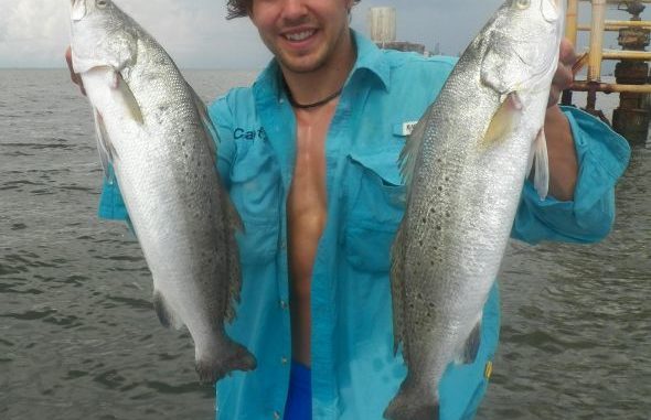
Laura and I arrived at the beach ready for a mid-morning run before fishing as planned, though this was no regular run. As she changed into her running shoes on the beach, she was completely surprised by what was hidden in them.
A diamond heart ring!
I was able to secretly video the whole thing so we can relive the moment. After having fun celebrating our engagement and picnicking with her favorite music, wine and snacks, we went after the fish.
A bunch of bad midday thunderstorms were avoided by running way out to Whiskey Pass. We fished in the Gulf through sunset, with perfect, calm conditions the second half of the day.
She caught more fish than she ever had before.
Without the help of the weather Web sites I’m about to discuss I would’ve never even tried going to the islands with so many dark clouds on the horizon. I certainly would have came back before lunch, missing out on all the great fishing that now has Laura completely hooked on fishing and, most importantly, me!
This past weekend I was able to fish with scattered storms everywhere with the help of radar screens on my phone.
Now to the sites:
Tides and moon phases are listed on many sites, but my favorite to use is saltwatertides.com for its simplicity and has both listed together. This site works great and is easy to use on a smart phone or computer. You choose the month, number of days to view and any one of the 42 coastal locations listed.
For weather, I’ve been using the LUMCON weather site for years. It has links to ample information concerning wind, waves and radar. This page will have a map in the center with clickable locations. When you hit a location, the actual conditions at these sites will be listed.
I always check the wind using this feature. Many times the forecasted wind will be very different from the current wind over the water.
On the left column of the Lumcon weather page, there is a link to the marine forecast put out by NOAA. This is my most-used and reliable information. Their wind, wave and rain forecasts are usually correct, but only give a broad picture.
When conditions seem questionable try more advanced options on the LUMCON site.
A neat feature is the 48-hour wave and wind forecast, which has an animated view of the Gulf. Just go to LSUwavcis, located on the left-hand navigation panel. This can be helpful because it’ll show when it’s calmest at different spots. Also, it’ll show if the Gulf waves are large, which sometimes they are even with calm bay conditions. That is useful when fishing barrier islands.
These wave and wind animations are accurate, as my years of using them have proven. I like playing them on the slow speed option. There is only one wind map that is labeled NAM. My favorite wave animations is the first one, called Mike21. Also included are future forecasted animations of surface current, water temperature, salinity and water levels if those are of need to you.
For offshore information the LSUwavcis main map has links to offshore rigs where up to the minute wind and wave information can be obtained.
When radar is needed, which is often the case, the Lumcon weather site has a link to the quickest radar available with a less than five-minute lag time. Clicking the “weather service radar” button in the left column brings you to a page showing the entire Louisiana coast.
If you click the pan & zoom button at the top of this Intellicast radar screen it’ll bring you to the interactive radar map. This interactive map is my most-important bookmark on my phone. It will let you hone in on any storms.
By playing the radar animations, directions of storm movements can better assist your fishing plans. When storm clouds are moving in the direction of the radar screen you can predict their next move. When storm clouds are moving in the opposite direction or in all directions, it’s time to get out of dodge; that’s when storms are developing on top of you.
Also, on the top column of this Intellicast page you can go under the “Storms” and then “Severe Weather” tabs and click on “Lightning Strikes.” This will show the lightning strikes in the past 30 minutes and hour. The page is accurate, and can help you decide if any oncoming storms are dangerously electric or nothing more than a friendly shower. By the time you hear thunder, sometimes it’s too late to make it in.
Many people use the more-popular Weather.com for information. Weather.com’s radar may be slower and limited in comparison to Intellicast’s performance; however, weather.com has two key features that I do like.
They have the “next six hours” button on their radar screen that animates radar of where future storms will be throughout the next six hours. This option isn’t available on the mobile weather site, so I bookmark the regular radar screen on my phone to access the future map. The mobile radar is bookmarked, too. It is very useful for low-reception areas because it loads quicker and easier than any other radar I found.
Also, Weather.com’s hourly forecast, which is more detailed than Intellicast’s hourly forecast, can be used as a guide. Many sites will just list morning or afternoon storms giving a percentage of rain for the entire day: The hourly forecast can better help estimate when the storms will be passing through. Usually it’s fairly accurate, but current radar is the only really reliable tool.
The only time I have trouble with storms is when they form on top of me. This is often the case in the summer, when no site can perfectly predict when that thunderhead will start forming.
I hope these sites have you spending more time with your line in the water this summer.
")
")