


If you want to catch some trout but don’t have a bay boat capable of handling the nearshore Gulf waters, just head to Cocodrie and work the bays that are the last step in specks’ late-spring transition.
Let’s start with a confession: I have an issue with hard-headedness. It spans well beyond fishing, but for this purpose we’ll focus on fishing — specifically the lifelong pursuit of all things speckled trout.
More and more often, I want to catch them bigger.
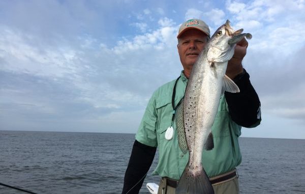
As one of Louisiana’s more-accomplished speckled trout guides, Capt. Bill Lake has shared this view — at least the speckled trout part.
Many years ago, he began extolling the virtues of the one-piece molded soft plastic swimbait, primarily as a wintertime super producer in the Cocodrie/Bayou Dularge area when the last of the white shrimp have moved into the Gulf to do what white shrimp do in the briny deep.
The baits, manufactured by a number of companies locally and worlwide, mimic small baitfish wonderfully in sustaining size and energy through the cold water months.
For just as many years fishing roughly the same waters, I scoffed. Some might say I held the baits in contempt.
They were expensive, the hooks in many seemed inadequate and — most importantly — there wasn’t a solid, comfortably grippable jighead to grab onto when loosing the hook from the latest conquest.
Pliers on every other fish is tolerable on topwaters and jerkbaits, but unacceptable otherwise.
And I always seemed to have one that just didn’t run right, pulling painfully to the side as opposed to a soft-plastic paddle-tail adorned perfectly on a round, unpainted, ¼-ounce jighead.
My come-to-Jesus moment took place in late April, as Lake and I drifted parallel to an old (and hopefully not dying) reef that has been producing late-spring speckled trout in heroic numbers for decades.
I threw a bright-colored paddle-tail bait — brand withheld to protect the innocent — as Lake reached back in time a few weeks (at least on his normal schedule) and tied on a 3-inch Tsunami swim bait in his favorite Bunker color.
“Normally, we put these baits away for the year by this time; the shrimp are usually running and the fish are targeting them heavily,” said Lake, as he whipped a long cast to the unseen southern tip of the heavy shell mound. “But for whatever reason, we’re not seeing many shrimp so far.
It took three fish on three casts by Lake — each one frothing the surface with a head shake a rat terrier would be proud of — before I got the message.
It took much less time for the deliciously familiar thump on the end of the 12-pound mono to signal a 16-inch speck was a lifted rod away from beginning its final dance of a life cut short.
Lake said an assortment of soft plastics — double-rigged Egret Bayou Chubs and Wedgetails tight-lined and the 3-inch Vudu shrimp under a cork — stay rigged and ready to go on his boat when fishing the busy, warm months around the oil and gas platforms situated just offshore.
But on several occasions, the swimbait has saved the day.
“Sometimes, everything out at the rigs looks right, and it’s just not happening. That’s when I’ll throw out a swimbait and just let it roll in the current,” Lake said. “I don’t really know how to explain it, but it’ll start catching them.”
Louisiana anglers — particularly speckled trout fishermen favoring fringe areas just off the coast — have been making the best of the state’s sad erosion of its smaller islands situated on the calmer backside of the barrier islands.
The common practice in finding these now-unseen current breaks and shell pads is to rummage through attics and storage containers — and even pester old fishing buddies — for maps of their area and compare them to present copies.
The advancement of Internet technology has brought us access to outstanding satellite images of the entire coast. Google Earth is the unquestioned leader in this space, providing “zoomable” images so close that the learned angler can recognize the ubiquitous pipeline warning signs.
And they’re both available for the low, low price of free.
Armed with that information, it’s not at all a reach to think one can find new “reefs” with the stroke of a key or the swipe of a touchscreen.
Simply download the Google Earth app on your phone or tablet, position yourself in a wide area in which you are familiar — or one in which you’d like to be — and zoom way, way in.
White shell banks, bleached by the summer sun are the first giveaway, but putting in a little time will reveal shell reefs — perhaps not oyster-based humps, but certainly the type of hard, uneven topography that gives the bottom of the food chain plenty of cover.
A similar application in using this technology is figuring out the extent of a reef you’ve found and fished in your on-the-water recon. Knowing just how far it extends can give you new perspective on its composition and a more-evolved strategy in attacking it.
Screen shots on computers and tablets can be printed and even laminated to produce custom maps. Those who are really organized — and leaning toward at least mild obsession with their craft — might be inclined to save these files and compare them to future versions.
An example would be comparing this year’s images of the eastern end of Raccoon Island — the last stretch of land of the Isles Denieres chain — to that of last year. The area that was once worked with topwater baits might now be solid ground as part of an aggressive sand dredging operation.
When talking about warm-weather speckled trout fishing, we’re mostly talking open water.
And few regions are more open than the area containing Lake Pelto and Caillou Bay to the west of the Houma Navigational Canal.
Even fishing the once-benign Bay St. Elaine can look daunting to the average angler, as islands have largely slipped beneath the surface and the old Sulphur Mine in bordering Lake Pelto appears as the only thing approaching the description of a safe haven between broken marsh and the barrier island chain.
But there are a few choices for putting together catches of late-spring speckled trout without beating every aluminum rivet and your trolling motor head to smithereens.
The area just north of Caillou Boca, known by some as Bay Round and others as Pelican Lake, provides a decent amount of wind protection with it’s bordering islands.
The two integrated and mostly indistinguishable bodies of water also contain plenty of fish-holding structure as speckled trout stage and gorge for their summer-long spawning run.
“What we’re looking for in Pelican Lake is mainly birds working over schools of fish, but there are a few good reefs on the western end,” said Lake, adding that on calm mornings schools of mullet will tell the tale in outing hidden fish-holding structure. “It’s real good for topwater fishing and corks.
“The one thing about it is that it’s only about 3 or 4 feet deep throughout — but that’s not usually a problem in the spring.”
Just to the south of Pelican Lake is the smaller Bay Round, which is more exposed to the easterlies common of late spring and summer.
But it’s also closer to the fish superhighway of Caillou Boca and Whiskey Pass, one of the more acclaimed wade-fishing spots on the Louisiana coast.
“It’s got a lot of good oyster reefs all around the edges, and there’s an old, small, wooden structure that holds a lot of fish,” Lake said. “It’s good — weather permitting, of course — the whole month of April for us, but still holds fish well into June.
“It’s just that, for us, we’re well outside looking for the big concentrations by the first of May most years.”
Capt. Brady Giroir of Cajun Waters Fishing Charters fishes the area extensively this time of year, and he said it provides an ideal staging area for the large population of trout that will soon make its way to the barrier islands and close offshore rigs.
“What they’re doing is staging up against that beach,” said Giroir, adding that for a month of good action is available to those anglers willing to work a little to find them.
Giroir said the less-than-desirable water clarity the season brings makes it important that anglers step out of their comfort zone in finding trout.
“We’re not big cork fishermen around here and, really, when we’re fishing out at the rigs in that pretty water, you want that bait to be moving and covering water,” he said. “But when it’s dirty, you’ve got to call those fish more.”
Lake said anglers preferring a more-visibly obvious structure than the hidden shell beneath shallow water can look to the fairly close structure known colloquially as “Pop-Top” (though little doubt upland and city folk from around the region have heard and passed along Cop-Cop, Pop-Cop or other iterations).
Lake said this structure, which is also known as the Pass des Isles (pronounced Eels) Tank Battery and located just south of the navigation channel that bears its name, not only serves as a staging area for spring transition trout but also is an outstanding location for night fishing and a place where live croakers can be fed to bigger fish through most of the summer.
“It’s a great location,” Lake said. “It’s only about a mile or two from Pass des Isles. About the only problem with it is that it’s a very busy platform. It’s an active, manned structure, so there’s barge traffic and crew boat traffic and tugboat traffic going on there all the time.
“And no matter what kind of bite you’ve got going on, when a work boat comes along you’ve got to move.”
The area from Pass des Isles to Bayou Grand Caillou is another easily negotiated stretch for first-timers and protected nicely from prevailing easterly winds.
Bayous spilling into Caillou Bay and indentations in the mostly rough shorelines make up the structures holding fish, though there are some shell banks that should be targeted.
However, Lake said a good run of shrimp in the area is imperative to success.
“That’s really the only time you see enough fish to make a good trip,” Lake said. “The rocks at the mouth of Grand Bayou DuLarge can produce pretty well.
“And for the most part they’re the only thing left.”
Editor’s Note: Capt. Bill Lake of Bayou Guide Service can be reached at 985-851-6015. Capt. Brady Giroir of Cajun Waters Fishing Charters can be reached at 985-870-0311.
")