Islands on the east side of Mississippi River are now underwater reef
Dear Capt. Paul,
By any chance do you have the latitude-longitude coordinates for a place called Hog Island? I used to fish it some 30 years ago.
The islands were barely above the water. There were goats, pigs and small animals on it.
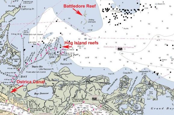
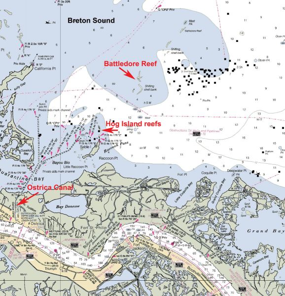
I believe that they are now underwater. The closet point of directions I can give is that they were on the east side of the Mississippi River near Quarantine Bay and southwest of Battledore Reef in the southern part of Black Bay.
Also, would you know of a map that would show the location?
Thanks.
BJ
Capt. Paul’s response:
Every now and again I like a mystery. You sure gave me one this time.
Not only do I have to find some very small islands, that are NOT marked on most maps, but I had to find an island that has not been visible for the past 30-odd years.
But, I believe I have located the Hog Islands you referred to. They are at or about 29°27.018’ N. latitude ~ 89°26.845’ N. longitude.
They were three small islands located about 2 1/2 miles north-northeast of Sable Island (36 degrees magnetic) and about 2.8 miles at a bearing of 220 degrees from Battledore reef (29°28.762’ N. latitude ~ 89° 25.120’ W. longitude).
They are in the southern part of Breton Sound on the east side of the Mississippi River. These small islands were called “Hot Islands.” They are also shown in Leased Area Block 34 of the Main Pass leased area.
They disappeared in the early to mid-80s.
These shell islands are now shown as underwater shoals or reefs. They are alleged to be slowly shifting their position, much as sand dunes move across a desert.
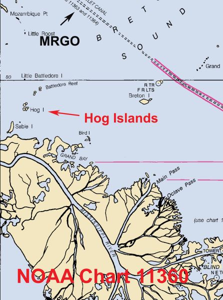
In addition, I located them on NOAA chart 11360 (Cape St. George, Fla., to Mississippi River Passes) at or about 29°25.316’ N. latitude ~ 89°28.441’ W. longitude.
They are named and shown on a 2005 chart as three small islands, sometimes above water, but the area around the islands has not been updated since 1982.
Other charts of the same area, such as NOAA Chart 11364 (Mississippi River Venice to New Orleans), drawn in a greater detailed scale do not show them as islands, but as shifting shell banks.
The easiest water access is via Ostrica Canal across from Buras and into the 6-foot-deep channel to the north-northeast to the aid to navigation light marked as Red 12. This marker as at or about 29°25.034’ N latitude ~ 89°29.240’ W longitude.
In addition, I located the positions of these islands, now shown as an underwater reef on USGS Topo map Mississippi River Delta, La. (29089-A1-TB-100) 1:100,000 scale dated 1983.
They are or were located about 2.8 miles northeast (33 degrees magnetic) from the north Sable Island aid to navigation (ATON) light Red No. 2.
The northern-most of the reefs is in the shape of a turkey foot, with the toes facing north. The center of which is at or about 29° 27.038’ N. latitude ~ 89° 26.860’ W. longitude.
Another reef that resembles a banana laying north to south with the open section of the slight curve facing west is about .4 miles SSE (163 degrees magnetic) from the northern reef, and is at or about 29° 26.690’ N. latitude ~ 89° 26.732’ W. longitude.
The smallest of the three is .3 miles west (267 degrees magnetic) of the “banana” reef and is at or about 29° 26.604N. latitude ~ 89° 27.082’ W. longitude.
Battledore reef is about 2.5 miles northeast (41 degrees magnetic) from these three islands.
I believe that the North East end of Battledore reef is at or about 29°28.854’ N. latitude ~ 89° 25.046’ W. longitude, and that the southwestern end of the reef is at or about 29° 28.687’ N. latitude ~ 89° 25.235’ W. longitude.
These are all underwater reefs. Approach it carefully. You will need a depth finder to pinpoint its exact location. The depth of the water around the reef is from 6 to 10 feet.
Water over the reef might vary form 1 to 4 feet, depending on the tide, wind, etc.
Current NOAA charts show several “shell reefs” moving from previous reported positions. Battledore Reef might be doing the same.
In addition, these charts show numerous oil and gas platforms just to the east of these positions. If you venture to the area, these are always worth your effort to try these locations.
They are shown on the aforementioned maps and charts.
All of the above maps and charts can be found at any competent map supply store.
All positions are listed as DDD,MM.MMM and are determined by using WGS 84 datum.
Keep the lines tight.
Capt. Paul