Let Mother Nature tell you where to target specks and reds this month.
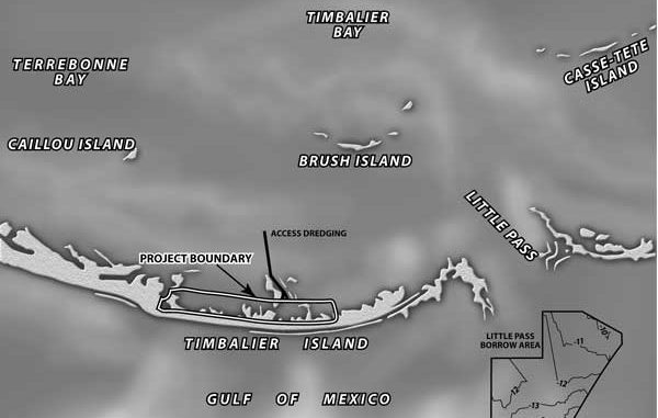
Those of you who like to fish the Isle Dernieres and Timbalier chain of barrier islands will be happy to hear that another member of the island chain is about to have some significant restoration work done to it. In June, work should begin on the restoration of Timbalier Island. While the western half of Timbalier Island is experiencing erosion, it is in far better shape than the eastern half of the island.
The eastern portion was overwashed by Tropical Storm Isidore and Hurricane Lili two years ago, and is now little more than some low sand flats.
According to recent surveys, the 350-acre project area now has less than 150 acres that are above the water level during low tide, and less than 30 acres above the water level during a high tide.
A few more storms, and the eastern half of Timbalier Island could disappear underwater altogether. If that occurs, the feasibility of restoring the area decreases significantly, and the cost of restoration increases greatly. As such, the timing for the restoration of Timbalier Island couldn’t be more important.
The Timbalier Island project is funded by the Coastal Wetlands Planning, Protection and Restoration Act (CWPPRA). While the project construction budget was $16.5 million, the lowest bid from the winning contractor (Weeks Marine Inc.) was $10.9 million, $5.6 million under budget.
The Environmental Protection Agency (EPA) and the Louisiana Department of Natural Resources (LDNR) are the federal and state agencies overseeing project implementation. These same agencies were responsible for overseeing the restoration work undertaken several years ago on the Isle Dernieres chain of islands.
Project implementation should result in the creation of almost 120 acres of dune (greater than 5 feet elevations) habitat, 32 acres of swale (2 to 4.9 foot elevations), and almost 200 acres of intertidal elevations. It is these back barrier island marsh habitats that appear to make the islands most resistant to breaching and erosion.
According to scientists who investigated the impacts of Lili and Isidore on the islands, those portions of islands that fared the best had the greatest amount of back barrier marsh.
After the sand has been deposited, sand fences would be constructed along the dunes to help capture sand being blown in the wind, and the appropriate vegetation would be planted in each habitat.
Planting, while a small budget item, is a very important component of a barrier island project, as these areas are not naturally colonized very rapidly by vegetation, and until they are, they can lose a large amount of sand to wind and wave forces.
No work is being done on the easternmost tip of the island due to some land-rights problems. While the problems could eventually have been worked out, it would have required action by the Legislature and delayed construction for another year.
As such, EPA and LDNR opted to move forward with construction of project features where the landowners had already granted their permission.
To construct the project, a hydraulic dredge will be used to mine the almost 4 million cubic yards of sediment necessary to rebuild this island. The borrow area for the sand to undertake the restoration work is located southeast of Timbalier Island in Little Pass.
The water depth in this area varies from 6 1/2 feet to 13 1/2 feet, and the depth of the cut will vary from 5 to 7 1/2 feet. As such, the borrow area will have a final dredged depth between 14 and 21 feet.
The creation of a borrow hole in this area is not expected to change the wave conditions or cause additional erosion, but it might create a nice fishing hole that would hold large red drum as they move to and from offshore spawning sites.
However, during construction, the area in the vicinity of the borrow and fill sites should provide for extremely poor fishing, as turbidity will be higher than normal and the disruption caused by the construction equipment might scare off the fish.
As such, since construction activities are expected to last up to 120 days, fishing in the vicinity of the eastern end of Timbalier Island this summer might not be a great idea.
Speaking of barrier island restoration activities, currently under engineering and design (through the CWPPRA program) are: 1) the restoration of four segments of barrier islands stretching from Grand Terre east to just past the Empire Waterway jetties; 2) some additional work on Whiskey Island in the Isle Dernieres; and 3) the filling of the breach (called New Cut) between East and Trinity Islands, also in the Isle Dernieres chain.
EPA and the LDNR are responsible for the Isle Dernieres work, while NOAA Fisheries and LDNR are the sponsoring agencies for the work in the Barataria island chain.
More information on those projects will be forthcoming as construction activities approach. If you can’t wait and want more specific information pertaining to each project, you might want to check out the CWPPRA web site (www.lacoast.gov).
Richard Hartman is the leader of the Louisiana Habitat Conservation Division office of NOAA Fisheries.


