
Can we find the cure in time?
Louisiana is facing an ongoing crisis of coastal land loss that threatens coastal communities, a rich culture and one of the most productive fisheries in the world.
Coastal marshes continue to disappear faster than any other landmass, with nearly 2,000 square miles of marshes, swamps, beaches and barrier islands sinking into the Gulf of Mexico or eroding in the past century.
The primary culprit is a lack of sediment entering the marshes from the Mississippi River on an annual basis. Levees and jetties built in the late 1800s and early 1900s to help prevent flooding and aid navigation cut off the sediment-rich flood waters that built south Louisiana over the last 25,000-plus years.
We’re sinking
Without sediment spilling over natural levees and into bayous and rivers connected to the Mississippi, marshes and barrier islands that are naturally sinking have struggled to stay above the water. Cutting off the connection to the river and man-made canals have also allowed saltwater to intrude far inland, killing and altering hundreds of thousands of acres of fresh and brackish marshes, leading to more coastal land loss.
To help slow land loss and try to rebuild parts of the coast, the Louisiana Coastal Protection and Restoration Authority developed a 50-year, $50 billion “Master Plan.” The funding is split evenly with $25 billion for restoration of coastal marshes, natural ridges and barrier islands and $25 billion for building physical structures like levees and floodwalls, elevating homes and making coastal communities more resilient to sea-level rise and hurricanes.
Efforts to restore coastal wetlands, ridges and barrier islands include dredging and depositing sand and sediments from the Mississippi and Atchafalaya rivers, the Gulf of Mexico and from lakes and bays, extensive replanting of trees and vegetation, hydrologic restoration and diverting water and sediment from the Mississippi River into coastal wetlands.
Large-scale dredging
Nearly 80 percent of the restoration funds are committed to large-scale barrier islands and wetland restoration though dredging. The bulk of the funding comes from fines levied against BP and other companies stemming from the 2010 Deepwater Horizon oil spill. Other sources include royalties from offshore oil and gas extraction.
In the past decade, some of the largest barrier islands have been built and the largest marsh restoration projects in state history undertaken, including complete restorations of East Grand Terre Island in Plaquemines Parish and Whiskey Island in Terrebonne Parish.
Mega diversions
Sediment diversions are by far the most debated and discussed restoration approach among fishermen and the scientific and engineering community.
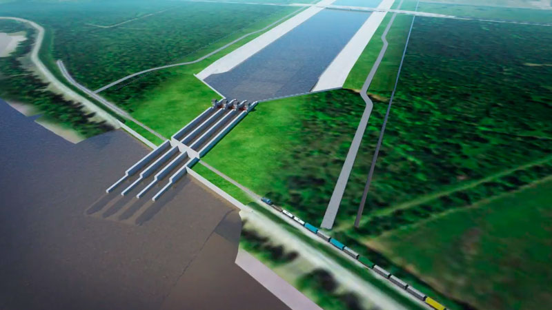
- Barataria Diversion
The Mid-Barataria Diversion will be near Myrtle Grove in Plaquemines Parish and can move as much as 75,000 cubic feet per second of sediment-laden river water into the Barataria Basin west of the river.
- Breton Diversion
The Mid-Breton Diversion will be south of the existing Caernarvon Diversion and will move as much as 75,000 cubic feet per second of sediment-laden water into the marshes east of the river. For some perspective, the maximum flow rate of Caernarvon is 9,000 CFS. Baptiste Collette Pass is about 200,000 CFS during high river periods and the Mississippi River flows at more than 1.25 million CFS during peak flooding events.
A smaller, 5,000 CFS diversion to help improve water quality in the Maurepas Swamp southeast of the Blind River is set to be built in the next five to 10 years, and a diversion to help restore the swamps the northwest Barataria Basin near Lac Des Allemands is envisioned in the next 20 to 30 years. The CPRA is also working to move more freshwater and sediment from the Atchafalaya Basin into marshes in western Terrebonne Parish to help prevent the widespread loss the eastern parts of the parish has experienced around Cocodrie and Pointe-aux-Chenes.
Construction for the Mid-Barataria Diversion is planned to begin in late 2021, with operations as early as 2026. Construction of Mid-Breton is to start by the end of 2023 and operations by the end of 2028.
Will they work?
Both projects are designed to mimic the natural land-building processes of the Mississippi River. Some of the few areas currently building land are ones where levees or other impediments to sediment deposition are not present, like the Wax Lake and Atchafalaya Delta, the West Bay Diversion below Venice and breaks along the east side of the river from the Bohemia Spillway south. Even at the Caernarvon and Davis Pond Diversions — which were designed to regulate salinities and not move sediment — small sub-deltas have formed at the mouths of the outfall channels.
More than 700 acres of freshwater marsh have been built at Caernarvon over the past two decades.
Extensive modeling has been conducted over the past decade to determine the optimal diversion locations and when operations will maximize sediment delivery. Both diversions are planned for sites where there is a “point bar” in the river, an area where sediments are naturally depositing at higher rates.
Tests have also determined that sediment rates are generally higher in the first few weeks of rising river levels, especially during late winter and early spring floods. These tests are helping the CPRA determine how to operate diversions to maximize sediment delivery while attempting to minimize freshwater inundation.
How will it affect the fishing?
The question for recreational and commercial fishermen is, what will all the freshwater do to saltwater fishing? There is no way to predict with 100-percent certainty how fisheries will change, but computer modelling to determine how water will move from diversions and extensive examinations of areas annually inundated with freshwater like Vermilion Bay, Black Bay, Lost Lake, Four League Bay and the Lake Pontchartrain Basin have been conducted.
They show shifts in fisheries and seasonal fisheries for some brackish-water fish, especially speckled trout, but not a loss of those fisheries.
When diversions are operating at maximum capacity, upper basins will become too fresh for speckled trout, and the fish will move to saltier waters. However, when flow rates are low or the diversions are closed, generally in late summer and fall, salinities will rise in the lower and middle basins in as little as two weeks, allowing fish to return to those areas. Those areas should have improved habitat conditions because of new wetlands, submerged vegetation and additional food sources created by the diversions.
It is impossible to completely freshen Louisiana’s coastal estuaries. The volume of saltwater in the Gulf of Mexico, tides and south and east winds pushing water into the numerous passes in the Breton and Barataria Basin will insure some saltwater in the lower parts of these basins even during diversion operations.

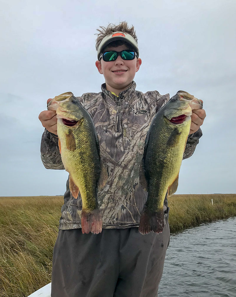
Bass populations will increase
Many of Louisiana’s most-productive, late-summer through early winter speckled trout fisheries are in areas fresh enough for largemouth bass and alligators.
An expansion of largemouth bass habitat and populations is expected, as well as more-suitable conditions and possibly larger populations of redfish, white shrimp, menhaden, blue crabs and mullet.
Also, a more-diverse forage base, including crawfish, juvenile crabs, shad and bluegill will return. Anglers in the Delacroix, Lake Pontchartrain and eastern Terrebonne areas regularly catch speckled trout and redfish that have been eating crawfish, shad and bluegill.
Capt. Lloyd Landry has guided speckled trout and redfish trips out of lower Plaquemines Parish for more than 20 years before recently moving his operations to Dularge in western Terrebonne. He said in both locations, adjusting to freshwater is something he does every day when the rivers are high.
Redfish will flourish
“In Buras, it was the Mississippi River, and in Terrebonne, it’s the Atchafalaya, but in both areas some of the most productive places, especially for redfish, are very near the dirty, freshwater,” Landry said. “The grass beds and marshes are better in areas where we get water and sediment. You might have to use some shrimp or go to dark colors like black and chartreuse baits to get bites, but I don’t shy away from that dirty water. Usually adjacent to the dirty water are ponds where the water is clean because it gets filtered by the grass. And I definitely fish those same areas for speckled trout in the fall because that’s where the shrimp and the pogies are.”
Oysters and shrimp will be displaced
Less freshwater-tolerant species and ones that can’t swim away like oysters and brown shrimp will be displaced to more historic ranges closer to the Gulf of Mexico or be concentrated in areas like the western Barataria and eastern Terrebonne basins where diversions have less of an impact or no effect at all. Because optimal oyster conditions are in brackish water with 10 to 15 parts per thousand salt (seawater is about 35 parts per thousand), additional areas closer to the Gulf of Mexico that have become too salty for oyster production will become productive again with diversion operation.
“It’s safe to say that we can look at areas like the Mississippi River Gulf Outlet or Vermilion Bay and get a sense of diversion operation,” said Brian Lezina, CPRA’s deputy chief for planning and research. “Those who fish the MRGO, Lake St. Catherine and Lake Pontchartrain know that salinities have come down a lot in the last 10 years, and there is a lot of submerged grass there now. It has created a year-round bass and redfish fishery, but also one of the best seasonal fall and winter speckled trout fisheries in the state.”
Lezina and other CPRA officials, the Louisiana Department of Wildlife and Fisheries and LSU’s Sea Grant are working with commercial and recreational fishermen and charter captains to help predict how estuaries will respond to diversions as well as continued land loss. CPRA will continue to meet with communities across the coast to discuss project impacts through their Coastal Connections program as well as public meetings for coastal restoration plans and diversions. Since December 2016, 90 meetings have been held.
“Part of fishing Louisiana is about adjusting to changing conditions,” Landry said. “Of course, we deal with high rivers and dirty water sometimes, but these rivers are the lifeblood of our coast. We lost all our marsh west of the river in Buras in the last 10 years. I and a lot of others had to adjust by fishing east of the river or moving to other parts of the state. Hopefully, we’ll be adjusting to new marsh being built soon instead of just marsh being lost.”