

Fishing closures on the east side of the Mississippi River were expanded dramatically this morning (July 5) by the Louisiana Department of Wildlife and Fisheries, which shut down all fishing in Lake Borgne, the extreme eastern portion of Lake Pontchartrain, Hopedale, the eastern portion of Delacroix, and some Pointe a la Hache waters in response to the BP Deepwater Horizon oil spill.
The closures were effective at about 11:15 a.m., the agency said.
Click here for a detailed map of the area from Lake Pontchartrain south to Delacroix. Click here for a map showing the Pointe a la Hache closures. Click here for a map of all state closures.
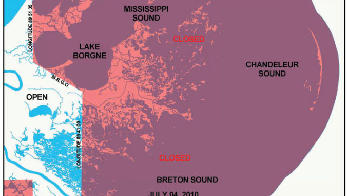
Now closed are water east of the Mississippi River north of the southern shoreline of the Mississippi River Gulf Outlet and the southern shoreline of Lake Pontchartrain from the double rig line westward to 89 degrees 51 minutes 35 seconds west longitude and the U.S. Highway 11 bridge in Lake Pontchartrain.
In addition to those waters currently closed to recreational and commercial fishing, major water bodies included in this fishing closure include the Biloxi Marsh, Lake Borgne, Lake St. Catherine, Chef Menteur, Unknown and Rigoletes Passes and a portion of Lake Pontchartrain.
The closure line runs north/south about the middle of Tanasia Lagoon, with all waters east of that line being shut down to fishing. Hopedale closures include Lakes Jean Louis Robin and Coquille, Oyster Bay, Hopedale Lagoon, Lake of Second Trees, and Lakes Celabasse and Machias.
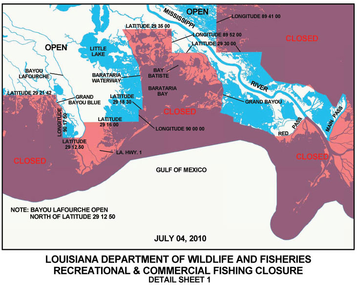
In waters out of Delacroix and Pointe a la Hache, fishing is excluded in all waters east of a north/south line just east of Four Horse and Round lakes. Closed waters include Lake Campo, Oak River Bay, all but the very western tip of Bay Lafourche, Bays Gardene and Crabe, American Bay, and Black and California bays.
Closed in St. Bernard and Plaquemines parishes, are inside waters east of the Mississippi River north of 29 degrees 30 minutes 00 seconds north latitude and south of the southern shoreline of the Mississippi River Gulf Outlet from the double rig line westward to 89 degrees 41 minutes 00 seconds west longitude.
")