Offers outstanding optical quality in a convenient size
Understanding rivers is important, both for finding fish on them and to navigating them. The smaller the river is, the more important it is to understand it, but the easier it is to understand.
Every river lies in a valley, even though the valley walls may be almost unnoticeable. The bigger the river, the bigger the valley. For example, the width of the Mississippi River Valley at the latitude of Baton Rouge extends from Baton Rouge on one side to Opelousas on the other. Valleys are often called “floodplains.”
Everything inside the valley has been carved by the river at one time or another in its history. Like a writhing snake, a river slowly but constantly changes its position in the valley over time.
The “uplands” on either side of the valley have never been part of the river bed, but are assaulted by the river’s currents whenever a loop of the river has traveled far enough across its bed to be directly up against the valley wall.
Rivers that descend steep gradients tend to be quite straight, as water seeks its most direct route to sea level. Rivers near sea level or rivers that flow over an area of gradual descent in elevation throw huge loops in either direction and are very crooked.
Rivers in between the two extremes have in-between characteristics. The stretch of the Amite River that Crochet fishes is of this type.
The two banks of a river are usually very different from each other, especially in river bends. The sharper the bend is, the greater the difference is. On the outside of bends, the river has the greatest current and is actively cutting into the bank. As the bank collapses, it produces steep “cut banks.”
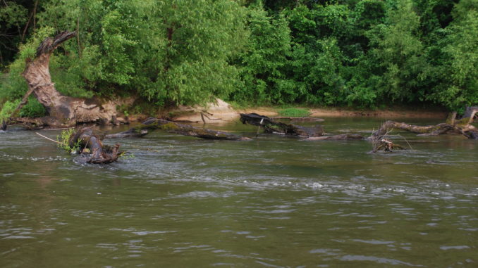
The water is deepest here. But it is often cluttered with tree stumps and whole trees that have tumbled into the water after the river has cut their roots from under them. The woody debris provides cover for fish as well as respite for them from strong currents. Cut banks are always steepest where the outside of a river’s loop has traveled far enough across the valley to be cutting into the uplands along the valley.
The inside of each bend in the river is extremely different. Water current is much slower here, and water that moves slowly drops its sediment load — silt, sand and gravel. This creates large gradually sloping deposits called “point bars.” A river’s waters are very shallow along point bars, and the bottom slopes only very gradually to deeper waters. The shallow waters near point bars typically provide minimum fish habitat.
The straight stretches between river bends are called “reaches.” Usually they are moderately shallow, with swift current. In the stretch of the Amite River that Crochet fishes, they are gravel-bottomed and seldom over knee deep, often even less. They hold few fish, except where heavy woody debris is lodged and provides protection from strong water currents.
Reaches may have a single channel, but the shallowest sections will occur where the sediment load of the river is so great that the river breaks into many small channels that repeatedly meet and split. This is called a braided channel — the toughest to navigate and least productive to fish.
Editor’s note: This article is part of the River Fever feature in the September issue of Louisiana Sportsman. Digital editions can be downloaded right to your computer or smartphone.
Be sure to subscribe to ensure you don’t miss a single information-packed issue of Louisiana Sportsman.


")