An update on the Pickets
It looks like the actual well heads and Christmas tree and platforms in the area known as the Pickets will be removed.
According to the Coastal Conservation Association most if not all of the platforms will be removed, but there will be some artificial reefs constructed in the area.
Three separate reefs — each about four or five acres in size — should total about 15 acres of new habitat. These reefs will be located in 6- to 8-foot depths.
The work on these reefs should be completed this month.
When completed, I will provide our readers with the positions for these reefs.
That means that you still have an opportunity to log in some excellent fishing around The Pickets, as well as logging in some waypoints for the area.
I have provided most of this information before, but you might want to firm up hot fishing spots in the area.
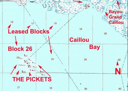
As most know, the owner of the platforms, Apache Oil Corporation, is in the process of removing some of the rig platforms that are no longer producing sites. These platforms are mainly in the Ship Shoal Leased Area, Block 26 area in Caillou Bay.
Anglers have reported that the platforms were removed, but the bottom area around these still had some deviations. Those platforms removed had the bottom cleared of refuse and structures.
I don’t doubt that an effort was made to remove the debris, but most often there is something left at the site. It might be only an irregular bottom, but all of these features draw and hold fish.
The Pickets stand in an average of only about 8 feet of water. So you should know where they are located when navigating in the area.
With that in mind, I put together some of the locations where the Pickets are or were located.
Although most of the sites are in the Ship Shoal Leased Area Block 26, there are a couple in Leased Block 25 that is just to the east of Block 26 and one in Leased Block 38 to the southeast of Block 26.
I suggest you save this information for your trips to that area.
As I said, some of the sites have been removed, but it might pay you in fishing results to know where they were once located.
Write down the positions and either manually transfer them into your GPS unit or use your manufacturers Data Transfer Program. To use the electronic transfer program, you would type the positions into the program via your computer, and then transfer them all at once as electronic data via the program into your GPS unit.
This electronic transfer is the basis of my Captain Paul’s Fishing Edge of GPS Waypoints.
The Pickets are west of Isles Dernieres, most particular Raccoon Island in the Isles Dernieres.
The Last Islands (Isles Dernieres) are made up of several barrier islands. They are (from east to west) East Island, Trinity Island, Whiskey Island and Raccoon Island.
Raccoon Island is the western-most of the islands, while Wine Pass on the easternmost tip of East Island at Terrebonne Bay is the eastern-most of the islands. These islands cover a distance of more than 20 miles.
The western-most part of Raccoon Island — or what is left of it is — named Raccoon Point. It is in the southern part of Caillou Bay.
This western-most shoal of Raccoon Point is at or about 29° 03.650’ N. Lat. ~ 90° 57.505’ W. long. The eastern tip of EAST Island at Wine Pass is at or about 29° 04.264’ N. lat. ~ 90° 38.095’ W. long.
Erosion has taken its toll on all of the islands. Some might not even resemble what they looked like a few short years ago, so be sure to get a current map before venturing into the area. NOAA Marine Chart #11356 ~ Isles Dernieres to Point au Fer and Chart 11352 ~ New Orleans to Calcasieu River- East Section would be the barest minimum that you should have.
In addition to showing the islands, it shows the shoals and drop-offs in the area.
Starting from Raccoon Point and heading west, the bodies of rigs, generally on the same line, are called the Pickets, Mardi Gras and the Blue Points rigs.
Present and past locations of some of the oil and gas wells/platforms in Leased Blocks 25, 26 and 38 in the southern part of Caillou Bay are commonly called the Pickets.
The well sites are numbered by me in their respective blocks. The main platform was indicated as being at or about 29° 06.500´ N 091° 03.500´ W and is indicated as my number 26-09 (Leased Block 26, ~ Platform / rig # 09).
Please note that all positions in this article were determined using NAD 27 DATUM. I suggest you convert the NAD 27 datum to whatever datum you normally use or simply change the datum setting on your GPS unit to NAD27 and enter the positions, and then change the datum back to the more standard datum of WGS 84.
If you provide these positions to other anglers, be sure to advise them that NAD 27 datum was used for these positions.
Here are a list of others positions in the Pickets area:
25-01 — 29° 05.847´ N/091° 02.088´ W
25-02 — 29° 05.796´ N/091° 02.025´ W
26-01 — 29° 05.909´ N/091° 02.989´ W
26-02 — 29° 06.232´ N/091° 03.155´ W
26-03 — 29° 06.232´ N/091° 03.164´ W
26-04 — 29° 06.268´ N/091° 04.705´ W
26-05 — 29° 06.529´ N/091° 03.492´ W
26-06 — 29° 06.500´ N/091° 03.492´ W
26-07 — 29° 06.529´ N/091° 03.506´ W
26-08 — 29° 06.546´ N/091° 03.506´ W
26-09 — 29° 06.500´ N/091° 03.500´ W
26-10 — 29° 05.835´ N/091° 02.705´ W
26-11 — 29° 05.913´ N/091° 02.695´ W
26-12 — 29° 05.924´ N/091° 02.998´ W
26-13 — 29° 06.436´ N/091° 03.246´ W
26-14 — 29° 05.917´ N/091° 02.836´ W
26-15 — 29° 05.916´ N/091° 02.808´ W
26-16 — 29° 05.840´ N/091° 02.869´ W
26-17 — 29° 07.033´ N/091° 03.474´ W
26-18 — 29° 06.660´ N/091° 03.479´ W
26-19 — 29° 06.746´ N/091° 03.071´ W
26-20 — 29° 06.515´ N/091° 02.759´ W
26-21 — 29° 07.115´ N/091° 03.483´ W
26-22 — 29° 06.193´ N/091° 02.656´ W
26-23 — 29° 06.266´ N/091° 03.054´ W
26-24 — 29° 05.875´ N/091° 03.672´ W
26-25 — 29° 05.797´ N/091° 03.672´ W
26-26 — 29° 06.849´ N/091° 03.881´ W
26-27 — 29° 06.264´ N/091° 03.154´ W
38-01 — 29° 05.595´ N/091° 01.934´ W
38-02 — A mainly submerged wreck at or about 29° 05.132’ N/91°01.797’ W
All positions are stated as DDD,MM.mmm and were converted from the Bureau of Safety and Environmental Enforcement format of decimal degrees which were plotted in NAD 27 datum to the indicated format.