Federal officials closed some federal waters yesterday (May 11) in the Gulf of Mexico west of the Mississippi River in response to BP oil spill, and promised quicker decision-making and reopening of waters as oil movement allows.
The latest National Oceanic and Atmospheric Administration action, which went into effect yesterday at 6 p.m., extends closures in federal waters seaward of Louisiana state waters in the vicinity of Timbalier Island to waters off Florida’s Choctawhatchee Bay.
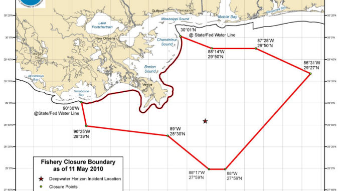
See the map, downloadable here, for detailed boundaries.
NOAA officials pointed out that 93 percent of the Gulf’s federal waters open for fishing.
Officials also said the closure process is being improved to cut down on the red tape necessary to modify the boundaries of the closure area.
“We’ve met with Gulf fishermen over the last few weeks and understand their need to receive rapid information,” said Eric Schwaab, NOAA assistant administrator for NOAA’s Fisheries Service. “NOAA stands shoulder to shoulder with Gulf coast fishermen and their families during these challenging times.
“Providing frequent updates about closed areas will allow fishermen to make good business and recreational decisions throughout this oil spill event, and will maintain public confidence in seafood from the Gulf of Mexico.”
The streamlined process also will allow officials to allow anglers to quickly return to some areas when oil moves away.
“Our plan is to use this new expedited process to open fisheries as well,” said Roy Crabtree, NOAA’s Fisheries Service southeast regional administrator. “If an area no longer exhibits oil and we determine through analysis that fish and shellfish are safe to eat, we will re-open that area to commercial and recreational fisheries.”NOAA also said that, from this point on, area boundaries could be modified daily based on where and how fast the oil spill is moving. LouisianaSportsman.com will continue to track and post adjustments.
Changes to the area closed to all fishing will be based on the present location and trajectories of the oil spill, which are affected by wind speed and direction, currents, waves and other weather patterns. Adjustments will take into account fishermen’s and consumer safety, while keeping open those areas not affected by the oil spill.
Any changes to the closed area will become effective at 6:00 p.m. the day of the announcement. The six-hour window is meant to give fishermen time to retrieve their gear from any areas that are about to close, and advance notice of areas that will soon open for fishing.
Status updates will also be available on NOAA Weather Radio and by calling NOAA Fisheries southeast regional office at 727.824.5305.
In the meantime, NOAA strongly advises fishermen not to fish in areas where oil or oil sheens are present, even if they are outside the closed area.
")