


When winds die down and Breton Sound turns to glass, head to Breton and Gossier islands for some of consistent trout action.
Sometimes you just have to drop whatever you’re doing and go fishing. Call in sick, take a vacation day, cancel the dentist appointment, postpone that emergency appendectomy (well, OK, maybe not that), but do (almost) whatever it takes to break loose and enjoy some aqua-therapy.
July is one of those times.
Down here, July is known for high temperatures and equally high humidity. Sweltering heat can make grown men weak at the knees and cause even the most avid fishermen to hide indoors.
That would be a mistake this month.
It would also be a mistake to think you can’t find trout in July.
Generally speaking, they can get harder to find as the summer progresses, and some anglers quit pursuing them altogether, opting instead to take the redfish alternative because reds seem as unfazed by the heat as they are by the cold.
Keep that option open as a Plan B if the conditions don’t allow you to implement Plan A.
Plan A?
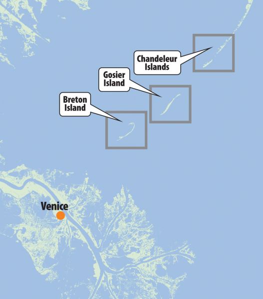
Head straight outside to the barrier islands, or at least to what’s left of them.
Breton Island is about a one-hour boat ride from Venice Marina. I made the jaunt recently when Capt. Owen “Big O” Langridge called, saying he just had a trip cancellation. Apparently somebody had booked a charter and at the last minute decided to cancel.
I can understand that sometimes things come up, events occur, the weather turns bad, people get sick, etc., and a client may have to cancel a trip. But this cancellation was for a day that called for perfect conditions, low winds, good tide and no seas to speak of.
Too perfect to cancel unless you’re hospitalized.
So I jumped at the chance to fish with Langridge, and we met at Venice Marina just as the sun got up. We also had a passenger: Venice Marina’s harbormaster, Paul Reeves, was coming along, and he provided us with a baitwell loaded up with nice live shrimp.
Once aboard, Langridge pointed the bow of his 24-foot Skeeter bay boat north into the river, and from there into Baptiste Collette Bayou.
“Where we headed,?” I asked the captain, over the roar of the 300-horsepower Yamaha four-stroke.
“Breton Island,” he said. “The weather is just too perfect. We have to give it a try.”
Then he explained why.
“Last July, Breton Island was on fire with speckled trout action,” Langridge said. “Of all the places I fished, Breton was the most productive and the most consistent area of the whole summer.
“I didn’t always limit out, but I always caught a good box of fish, and they were always nice-sized fish.”
Langridge said the trout bite was best sometimes right along the island, but other times it was better at the rigs and wellheads right around the island.
“Either way, that’s the prime area I’ll fish in July and August,” Langridge said.
Breton Island is a national wildlife refuge, the second oldest in the whole country. It’s the southernmost island of the Chandeleur chain of Louisiana’s barrier islands, and today is merely a shadow of its former self. When I first began fishing it years ago, it was huge, stretching out several miles long and thick with grasses. It was populated with a variety of critters, including rabbit, nutria and raccoon, all of which were decimated by Hurricane Katrina.
One hundred years ago, there were trees, houses, buildings of various sorts, several families who actually lived on the Breton Island and even a school.
Today the island is still grassy in sections, but the rest is not much more than a sandbar stretching out about 300 yards long. It is, however, still the home of a bazillion nesting seabirds, including gulls, pelicans and terns, and if you approach the island from downwind, you’ll smell it about the same time you see it.
I was riding in the back seat while Langridge and Reeves rode the cockpit, and even without having to look I knew when we got close to the island. The unmistakable smell of years of accumulated bird poop is an assault on anyone’s nostrils. And this is no ordinary poop: It’s seabird poop, of the digested, rotting seafood variety, so the acrid stench is doubly noxious.
We approached from the sound side, which is where Langridge usually begins his search.
“I look for three essential things out here,” he said. “Naturally, the first thing is the winds and seas. Once you exit Baptiste Collette into the open sound, you’ll get an idea of what you’re dealing with. If the winds are blowing 15 knots or more, I turn around. They make the seas rough and the water dirty, and with those conditions you’re wasting your time.
“If the winds are 10 to 15 knots, the conditions are marginal. Most of our winds are out of the southeast in July, so that gives waves the entire length of the Gulf of Mexico to build up momentum, making for some very tough conditions.
“You really need a day with light to calm winds to fish the islands, and we do get a lot of those days this month. I figure roughly four days out of seven in July, it’s fishable.”
And on this day, the seas were very calm, almost glassy. It was a day made to order for some island fishing.
“The second thing I look for is water clarity,” Langridge said, “and today, the water looks awful.”
Looking around the island, I saw he was right. The water had an ugly brown cast, like muddy river water. We made this trip just a day after another strong front moved through from the north, one of the many unusually strong late-season fronts we had this year.
Langridge said the north winds also tend to produce muddy water conditions, and coupled with a relatively high river spilling into the area, we were looking at a very disappointing sight — some very ugly water.
“The third thing I look for is bait around the island,” he said. “Any sign of bait activity at all is positive: Schools of mullet or minnows, shrimp jumping, anything fish feed on, that’s where you want to fish.
“Sometimes we find decent water underneath this ugly water. We won’t know until we try.”
We motored slowly toward the island, and Langridge killed the outboard once we got near the wreckage of the old Coast Guard station. Despite the lack of bait activity and ugly water, we were going to make some casts.
“We’re here; we might as well fish it,” he said.
Reeves and Langridge loaded their hooks with live shrimp under popping corks, while I tried working a topwater bait. I reasoned that the water might be too muddy for fish to see a suspended shrimp, but they could at least hear the thrashing of a topwater bait and zero in on the sound. It seemed like sound reasoning to me.
One other boat was fishing along the island on the sound side, and another was across the island on the Gulf side.
We worked our baits as Langridge trolled us near the structure of the old Coast Guard station and from there along the sound side of the island.
I had one good blowup under my topwater bait, but the dumb fish misjudged its target and exploded next to my bait instead of on it, somehow missing all the dangling treble hooks.
The live shrimp didn’t attract anything but a hardhead.
But recently Langridge had caught so many fish at Breton that he seemed reluctant to leave, hoping that at least some of the numerous redfish that call this island home would find their way to our baits; but it just wasn’t to be, at least not on this day.
Both of the other boats pulled out and headed elsewhere, and 20 minutes or so later, so did we.
“Where we headed, captain?” I asked Langridge.
“To cleaner water,” he said, “wherever we have to go to find it.”
As it turned out, we didn’t have to go too far. Gosier Island (or what’s left of it), the second-to-last in the Chandeleur chain is only a few miles to the east-northeast of Breton Island, and a mile before we got there the water looked green.
In fact, the closer we got the better the water looked, and that’s where the boats were stacked up.
As we approached the mostly submerged island, we saw several wade fishermen on the grassy shoal, casting toward the Gulf side. Langridge dropped the trolling motor and followed his usual routine, which is to approach slowly from the sound side, casting as you go to try and locate some fish.
“The sand out here is fluid,” Langridge said. “The scientists call it dynamic, meaning it’s always shifting about, moving, settling here and there. So the bottom contour can be slightly different from week to week. Besides that, the fish are always moving up and down these sandbars, so you never know just where you’ll find them.
“That’s where the fishing part comes in.”
So we fished. For the first 15 or 20 minutes, we worked along the sound side, trolling and casting our baits both toward the island and away from it, because you never know whether the fish will be close in or farther out.
But we noticed the other boats repositioning, moving to the Gulf side of the island, and we soon followed suit.
And that’s where the trout were.
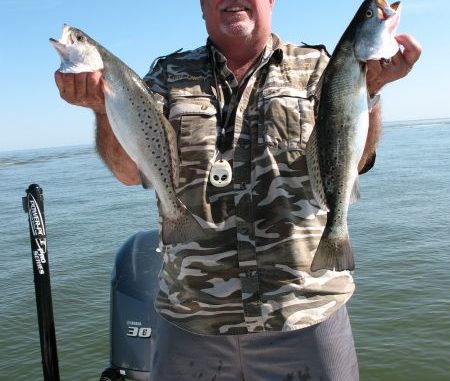
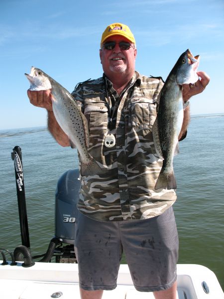
The very first fish we landed was a solid 2 pounds, and dozens of others just like it quickly followed. We caught several more in the 3- and 4-pound class, so these were very nice fish.
Langridge never put an anchor down, preferring to allow the boat to slowly drift and troll along the Gulf side, sometimes close enough to the island to drag bottom, other times farther away — even too far to make a long cast to the island itself.
And we’d drift in and out of the fish.
But one thing remained constant: The trout were hovering around the bait. Several large schools of mullet were moving back and forth, constantly in motion. Occasionally a huge crash would come from the edge of the moving school as predatory fish picked them off.
It was a angler’s paradise.
I tossed my MirrOlure Top Dog into the mullet swarm and worked it out to the edge of the school where hungry trout pounced on it.
Both Langridge and Reeves were wearing the trout out on the live shrimp, out-catching me by three to one. But I was in it for the thrill, and nothing is more exciting than a big trout exploding on your topwater bait.
I had plenty of these explosions, and then the pompano started biting.
Before the day was over, we’d caught a box of speckled trout, pompano, Spanish mackerel (plenty of those), bluefish and redfish.
The weather stayed perfect all morning and even the ride in was on glassy seas. I’m so glad somebody cancelled their charter that day: I got to punch their ticket, and it was a knockout.
To me, there’s something unique about fishing these islands. Maybe it’s that they’re so far off the beaten path that they maintain an air of remoteness, of being off somewhere in the Caribbean. Even the other boats out there don’t subtract from the feeling that you’re someplace aloof and alone.
Maybe it’s the sound of the Gulf of Mexico lapping at the beach right in front of you, or maybe it’s knowing that there’s nothing but water between you and Cuba.
Whatever it is, it’s unique and powerful, and it generates forever in you a desire to return and do it all again and again. At least that’s how it affects me.
On the ride home, Langridge lamented the state of our barrier islands.
“Back before Hurricane Katrina, there were a couple of nice houseboats that set up on Breton Island,” he said. “Guide boats worked out of it, and boaters could even go there and get a room for the night and meals. It was a great set up. Who knows: Maybe some enterprising young man will start a new venture out there. I’d sure like to see it happen in my lifetime.”
“Me too,” I replied. “Me too.”
DESTINATION INFORMATION
Venice is about 85 miles from New Orleans, all the way to the end of Louisiana Highway 23, so you’ll generally want to allow yourself about two hours for the drive from the Big Easy.
Marinas
Two excellent marinas operate out of Venice: Cypress Cove Marina (504-)534-9289) and Venice Marina (504-534-9357).
Both facilities have triple back-downs, fuel, ice and accessories, a restaurant and lodging.
Venice Marina has live and dead bait. Cypress Cove currently offers only frozen bait.
Maps/charts
Standard No. 343 shows the route from Venice.
Coordinates
According to Capt. Paul Titus the coordinates of the islands are:
Breton Island — 29.29.729 N/89.09.287 W (the northern part of Breton Island)
Gosier Island — 29.33.582 N/89.03.395 W and 29.32.012 N/89.05.083 W.
Curlew Island (or what is left of Curlew Island) — 29.37.921 N/88.58.583 W, or about 15 miles at a bearing of 51 degrees from the north point of the Breton Islands.
Use caution when navigating to these positions as there are parts of the islands that are now reefs, and are just below the surface of the water.
")