

Google Earth gives anglers big advantage in finding potential fishing spots
If you’ve been fishing for specks and reds at all, then you know how important clean water is.
In fact, it’s part of what I call “The Big Three,” which consists of clean, moving water and the presence of baitfish.
Locate those three conditions in one spot, and your odds of limiting out are much better than fishing other, less desirable locations.
But that’s not all. As I’ve spent time looking for “Big Three” conditions, I’ve noticed another factor that seems to be a key player: The ability of a body of water to remain consistently clean over time, despite good or bad conditions.
Some of the best spots I have share this characteristic, which caused me to pay more heed to it and wonder how I could locate more locations like it to catch fish.
Now, I’ll tell you that nothing beats experience. Utilizing time on water to observe these things firsthand is simply irreplaceable, but there is a neat trick you can use to shorten this learning curve and make your limited time more productive.
Back to satellite imagery
The advantage of available satellite imagery to inshore anglers cannot be overstated.
Learn how to interpret these images, and you’ll make better use of this tool than others looking at a hand-drawn map.
The best way to do this is by employing Google Earth — not the smartphone app, but the desktop program.
To be clear, I am not referring to Google Maps, either. While that site does provide a satellite image, it is a single image from one point in time, not many over a period of time.
Google Maps also lacks the tools of Google Earth, so it’s not an acceptable substitute.
Detecting clean water
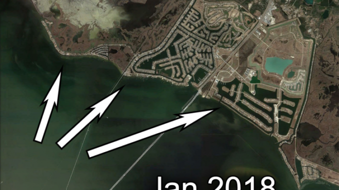
With Google Earth, you can observe how clean water is.
See, clean water tends to appear darker in satellite imagery, whereas dirtier water appears to be lighter in color.
If you’re still not sure, use the Mississippi River as your “go to” for what dirty water looks like, since it’s always dirty.
Anyway, some images are clearer than others, but it’s usually enough to tell what is clean water, and what isn’t.
Go back in time
Google Earth’s real power lies in the Time Slider, which you can move left or right to browse images taken over the course of several years.
So, when you locate clean water in one spot, you can identify its consistency (or lack thereof) by sliding through the years.
Pay attention to the season, proximity of river diversions or anything that can muck up water clarity.If the spot appears clean over time, then you may have a winner that’s definitely worth checking.
Conclusion
This process can be difficult to explain without the aid of pictures, so be sure to look at those included at the top of this article.
Make sense of it and you’ll see this isn’t rocket science, but rather a very practical application to bring a new edge to your fishing prowess.
Tight lines, y’all.
Editor’s Note: Devin Denman is an avid inshore fisherman. To read more of his articles, visit lafishblog.com.