Tropical storms have battered the famed speckled trout fishing locale, leaving structures and rocks sumberged in shallow water.
Every time the weather warms, South Louisiana residents have to keep their collective eyes on weather radars to be ready for when tropical storms are heading their way. It also turns out that the same storms that have such a drastic impact on Louisiana’s population give reason to be mindful of something else — the coastlines themselves.
That’s because as each annual barrage of storms bears down on Louisiana marshes, lakes and bays, the aftermath can alter the coastline to such a degree as to make the landscape hardly recognizable for even the most seasoned of boaters and anglers.
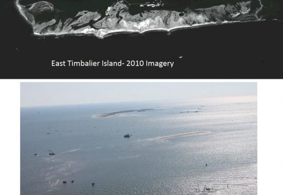
Take, for instance, East Timbalier Island — long one of the most-productive speckled trout fisheries in the Terrebonne Basin. For years, anglers have headed there for some of the state’s largest specks, and they’ve had no problem finding the area, which was buffered by shell breakwaters and dotted with oil and gas wellheads.
The same anglers probably won’t have too big a problem finding the area now, either, because the same structures remain; however, many of them now are half covered by shallow water that officials say makes East Timbalier a particularly dangerous area.
“We had two really tough tropical systems that just plowed through that area and brought some potential problems with it,” said Tim Osborn with the National Oceanic and Atmospheric Administration Office of Coastal Survey out of Lafayette. “East Timbalier is a really good example of what kind of damage you’ll see when you get storms like that; slow-moving storms.”
Specifically, blame Tropical Storm Lee and Hurricane Isaac, both minor storms in terms of force on the Saffir-Simpson Scale. Both hit the East Timbalier area for hours with their full force, and then stubbonrly lingered over the Terrebonne Basin before rumbling slowly inland — bringing with them further flood and destruction.
To the small coastal island, that meant having to endure a great deal of storm surge, wave action and wind. The ongoing toll is obvious and striking, considering Isaac made landfall more than eight months ago.
“This is definitely going to be something to look into, in terms of it being an issue for the upcoming fishing season,” Osborn said. “There has been a severe hurricane impact on our coast, especially in the East Timbalier region, recently. Wine Island in Terrebonne Bay has been impacted, too. That means new hazards. Anglers will need to be aware of where they are going, for sure.
“The regulars down there have seen the impact, with those old rock breakwaters now being well off the shore of the island. There is stuff submerged there; it can be a real hazard to boaters …. There are shoal bars; there’s oil-field equipment.”
Port Fourchon Harbor Police Chief Jon Callais echoed Osborn’s sentiment, and said there are some real problems around any area hard-hit by a storm — but he said East Timbalier is particularly striking in its recent degradation.
He went up in a helicopter for an aerial view on March 30 and said he got a whole “different perspective from up there.”
“There’s no way I would run a fishing vessel through there,” Callais said. “Maybe you can anchor or maybe put your trolling motor down and look around.
“But otherwise, I’d steer clear.”
Osborn said he’s especially concerned with the problems, considering the height of fishing and boating activity is right around the corner, when warm weather will beckon boaters by the hundreds to a popular area like East Timbalier. The fishing rodeo season, which soon also will get going in earnest, is another reason to worry about the amount of boat traffic there.
“People have to be really vigilant, really aware when they are out there enjoying the water,” he said, noting that there are no markers or lighted buoys to alert boaters of any potential hazards. “On a calm day, with the sun shining and no wind, (the boaters and anglers) will be out there, and they’ll see what we’re talking about.”
Callais said he’s not sure which entity might be responsible for marking the area as hazardous, noting that his department stays within port boundaries and only ventures into open water a few hundred yards, outside of the Timbalier region. That doesn’t stop him from having concerns over the East Timbalier area, however, as he reported the island is not much larger than a football field these days and the water surrounding it is extremely shallow.
“We have to get the word out to warn boaters,” he said. “It can be dangerous.”
Osborn said anyone venturing toward East Timbalier is not only advised to use extreme caution, but also to alert the proper authorities if they see anything that could be hazardous to fellow anglers and boaters.
The NOAA office can be reached at 337.291.2111. Osborn also suggested reaching out to the U.S. Coast Guard or the Louisiana Department of Wildlife & Fisheries if hazardous conditions are spotted.
“You may hear the talk, but when you are out there you clearly see what happened to that part of the coast,” Osborn said. “Be mindful and let someone know (before anyone gets hurt.)”
