
Coordinates to Golden Meadow hotspot
Dear Capt. Paul:
Can you provide the coordinates for Little Grey Duck Lake and Grey Duck Lake in the Golden Meadow/Catfish Lake Area?
Respeckter
Capt. Paul’s response to Respeckter:
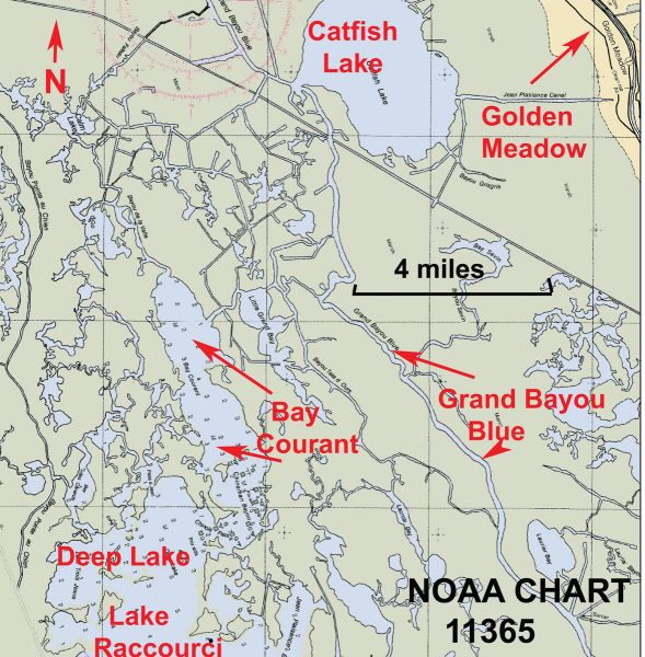
I believe Grey Duck Lake is a common name for Bay Courant.
This is common though-out Louisiana, as these places were named for the terrain or features of the area. “Courant” in French means current, but not all maps have names listed on them, so terms were given to relay the location they were speaking about.
According to a story published on LouisianaSportsman.com titled “The time is right to catch speckled trout south of Golden Meadow,” Anthony Taylor relays information for fishing the Golden Meadow area — and a water body known as Big Grey Duck or Bay Courant is mentioned.
If that is the area you are asking about, Grey Duck and Little Grey Duck (Bay Courant and Little Bay Courant) are located about 2.5 miles south of Clam Lake via Bayou de Valle.
They are east of Bayou Jean Lacroix and the Terrebonne/Lafourche parish boundary.
It is also west of Bayou Courant, Bayou Tete d’Ours and Grand Bayou Blue, about six miles at 242-degree magnetic as the crow flies from Golden Meadow and directly north east of Deep Lake.
Bayou de Valle enters the smaller part of Bay Courant at or about 29°0.535’ N. ~ 90° 21.2170’ W.
The bayou continues southward in the upper part of the lake to a point where the east and west shorelines begin to converge. This is basically the point where the larger part of the bay meets the smaller part. This is located at or about 29°19.3751’ N. ~ 90°20.8989’ W.
Moving southward again the bay continues into Chinaman Bayou and Chinois Pass, which is at or about 29°17.8864’ N.~ 90° 20.2640’W.
There are a series of aids to navigation day markers beginning is Deep Lake marked as Green N. 1, G No. 2, G No. 3, G No. 4, G No. 5, etc., continuing northward to Green No. 19.
Get a decent NOAA chart, such as Chart 11365 or a current USGS topographical map of the area, to assist you in navigating to and from the bay to your launch.
Unless otherwise specified, all positions are stated as degrees, minutes and thousandths of minutes (DDD,MM.mmm) and were determined using WGS 84 datum. All bearings and courses are stated in magnetic degrees.
Capt. Paul
