Now is the time to really scout and mark your hunting area
Yes, now is the time to really plot your hunting area with your GPS.
For those of you who have handheld GPS units you will really get the most out of the unit while in the woods or duck ponds if you plot some key positions in your hunting area and use the TRACKBACK feature.
No, I don’t mean for you to give up a hunting day, but a post-hunting-season trip back to your hunting area with your GPS will really pay off next season.
This time of the year the woods are usually devoid of brush and tree leaves, making it an ideal time to see the game trails, deer rubs, scrapes, bedding areas, etc. You might find trails you never knew existed, and improve locations for blinds or stands.
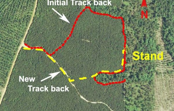
I had a perfect stand located along a game trail that formed a hair-pin track. Looking at the stand from the GPS Backtrack, I could save over a mile of walking by simply cutting across the area to where the trail continued. It was well worth my time to back up my trails on my computer where I could get a good look at the actual track back. The new route to my stand was shortened considerably.
To begin with, check your configuration settings in your GPS unit. As I have described in previous articles, you should double-check the main settings in your unit in order to get the most out of your GPS unit.
First, set the DATUM to WGS84, and then check the POSITION FORMAT, called Location or Grid by some manufacturers. Set that to a grid format of Latitude~Longitude in Degrees, Minutes and thousandths of minutes. (DDD,MM.mmm). That setting will display the position to the most commonly used grid and maps now in use. Then set your distances to statue miles, which will show the distances in feet, yards and statue miles and check the North setting. I use the magnetic North setting. That way the GPS unit will match the readings on your compass. Then activate or enable the GPS to receive the WAAS differential satellite signals. This will allow your GPS to determine positions to within 9.8 feet.
Now, backup all of your waypoints, routes and tracks. You will need the recommended data transfer program in order to complete the backup to a computer. If you don’t have such a program, contact the manufacturers to see what they recommend. Some companies offer free downloads, while some charge a moderate fee for a DVD or Internet download.
With those settings and the data backup program installed on your computer, you can head to your hunting grounds. Pick a decent day and allow yourself at least five hours in the middle of the day to cover the entire area. Start with a fresh set of batteries and an extra set as a spare.
Now clear your ACTIVE TRACK, or TRACKBACK feature in the unit. If you have some waypoints already captured or entered in your GPS unit you might not want to erase them. Either way, you should begin entering all of your new waypoints with some sort of unique name or symbol.
I carry my GPS as high as I can. I had my wife sew a pocket on a vest to hold the GPS high on my off shoulder. This is to let the GPS get the best satellite reception. It works like a charm.
Be sure the TRACKBACK feature is on and working. Start where you enter the woods. Name it something like Truck or Launch. Walk or navigate to your blind or stand as you did when hunting. Mark the actual location by marking a new waypoint. Do this even though you might have marked the position while actually hunting from the location. Use the route you would use if you were hunting that day.
Double-check the area for new sign or activity. If you find any, mark and save the locations as new waypoints. Check the flyways or trails you covered from the stand or blind location. In your mind’s eye determine if a slight change of position would enhance shooting opportunities. If so, move to that location, and mark and save a waypoint for that spot. Now would be the time to trim any vegetable matter or obstacles that may interfere with your shooting lanes.
On one deer hunt, I had a decent stand, but later by simply moving 20 feet, I could cover the same area plus two different game trails I did not know existed. This slight move in effect tripled my shooting opportunity. While walking the area, I marked all the scrapes, rubs, new or previously unobserved game trails, droppings, bedding areas and antler shed drops I found. I included locations where I had taken game before, and I also included turkey signs that could be used for the oncoming spring season. This provided me with a great overall appreciation of the area and opened up the possibility of several additional stand locations.
After completing the post-season scouting, save the active track-backs in your GPS unit. You will have to give it a name to do so. Actually, you could even save each leg of your tracks as a different track. Most GPS units allow you to save up to 10 or more such tracks.
Then, when you get back, backup the data to a computer file. From there you can edit any of the waypoints if necessary and convert the TRACKBACK trails to a route. You can select a different color for each track, now a route. Doing so will allow you to use the route over and over again without contaminating the original pathway, and the GPS unit will give you directions and distances to your next turn. It will also let you view the egress and exit paths of the area.
Make a few notes to refresh your memory when you again begin hunting the area again.
Next year, do your normal prehunting scouting, taking particular notice of your new waypoints and notes about the area. You will find the information you saved invaluable in your hunting the area.


")