Understanding position format is first step
I know that I have written about configuration settings for a GPS unit in the past, but during my seminars and at least once a month I get a question concerning how a reader’s GPS should be set up.
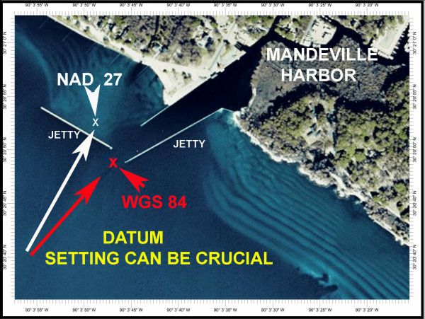
Many questions center around given positions from friends or published data that do not agree with the allotted spaces in their GPS unit for those locations, or the position is not located where it is supposed to be. Most of these problems are attributed to an improper configuration of their GPS unit.
Fortunately, the various GPS manufacturers have decided on a standard default for their setup configurations. This is at least a step in the right direction, but many times a GPS user might have a GPS unit that was a store display, or someone was experimenting with the unit and changed the initial configuration settings.
So, to clear up some of the hundreds of different settings that can be made in the GPS unit, I have come up with what I call the ABCs for setting up GPS units.
This month, we’ll deal with the first of those setup issues, and finish the discussion in the October issue of Louisiana Sportsman.
First, I must say that there is no wrong answer or “correct” selection for each of the different configuration settings; they all will work in the unit, but the numerical values might not agree with the default settings or those given to you by another source. My suggestions define a common ground for owners to use. It is much like singing the same song rather than each user singing different songs.
The major settings include the Grid Systems settings called POSITION FORMAT, or the Location Format or Grid Systems; DATUM, NORTH REFERENCE; TIME SPEED SETTINGS; TIME OFFSETS AND INITIALIZATION.
Knowing the choices and what they mean can allow you to better configure your unit for your own use and get the most out of your GPS unit.
Start with the POSITION FORMAT selections
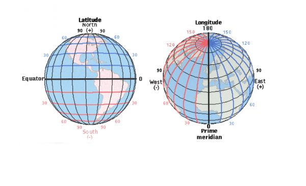
The Position Format settings in most GPS receivers can be set to eight or more different grid formats. Some of the more-common grid formats such as Universal Transverse Mercator (used when plotting positions on U.S. topographical maps), Universal Polar Stereographic (also for topos near the earth’s poles), Military Grid Reference System (used when plotting positions on military maps) are designed in meters north of the equator and east of different meridian zone lines. Loran TDs are, of course, settings for latitude-longitude.
Each of the different selections will describe the same position in a different format. Think of them as different languages describing the same object. The numerical value in each format will be different for each of the positions, but they will all be describing the same position.
This means that, if your configuration setting is set to latitude and longitude, and your friend gives you a position using a UTM format, that position cannot be entered into your unit unless you convert both formats to the same format. You can either change your Position Format from latitude-longitude to UTM and enter the position, or convert the UTM position to a latitude-longitude format.
There are several computer-based programs that can be found on the Internet that will do the conversion for you, but the easiest way is to change the setting in your GPS and enter the positions, and then return to your normal or default setting. The GPS unit will do the conversion for you. This would apply for all of the different grid formats that are in your unit.
In selecting the different formats, you will be directly in the format of the way positions should be entered. This is not so with latitude-ongitude.
Latitude and longitude positions are what usually causes the most problems, as most GPS units have three subsettings in the latitude-longitude choice.
All latitude and longitude settings are expressed in parts of an arch on the earth’s surface. Most GPS units have latitude-longitude settings that allow you to select the values for the arch in several different formats.
It is this confusion that causes the most concerns with some users.
The latitude-longitude formats can usually be displayed, and entered in three different latitude-longitude formats.
Decimal degrees (DDD.dddddd shown as 30.123456° which contains no minutes or seconds); degrees, minutes, seconds and tenths or hundredths of a second ( DDD,MM,SS.ss shown as 30° 10’ 30.12”); and degrees, minutes and thousandths of a minute (DDD,MM.mmm shown as 30° 10.500’ or sometimes .mmmm /ten-thousandths of a minute) can be used to describe the exact same position.
Usually these setting are prefixed by an “H” which refers to the hemisphere: “N” for the northern hemisphere and “W” for the western hemisphere for North America. (H,DDD,MM,SS.ss)
It is not possible to enter a position described in one format into a unit that is programmed for a different format. So you must convert the value of one of the formats to coincide with each other.
To convert seconds and tenths of seconds (SS.s”) or hundredths of seconds (SS.ss) to thousandths of a minute (.MMM), divide the seconds by 60. (30 seconds divided by 60 = .500 minutes) and replace the entire seconds with a decimal part of a minute.
For instance a position of N 30° 03’ 31.32” is equal to 30° 03.522’ (h,DDD, MM.mmm). Remember that the longitude part of a position also needs to be converted to a common value. Such as a position of W 89° 59’ 36.59” (DDD,MM, SS.ss) would convert to W 89° 59.6098’ rounded to W 89° 59. 610’ (DDD,MM.mmm).
To reverse the procedure — to convert thousandths of a minute (.MMM’) to seconds (SS.S”) — multiply the thousandths of minutes by 60. (.450’ [minutes] x 60 = 27.0” [seconds]) expressed as DD,MM,SS.s.
Remember that if the figure is greater than 60 (60 minutes or seconds) it increases the next-highest category. 89° 59’ 50” (DD,MM,SS) plus 20 seconds equals 90° 00’ 10”.
If the math scares you, change the POSITION FORMAT, or as some units refer to the latitude-longitude settings as LOCATION, to H, DDD,MM,SS.s or the H,DDD.dddddd in your GPS unit, and enter the positions and then change the settings back to the H, DDD,MM.mmm settings for your normal work.
The GPS unit will do the conversion for you.
In the H.DDD.mmm format, a one digit change in the last decimal place equals about a 6.1-foot difference. A format of H,DDD,MM,SS.s means that a change of one tenth of a second difference equals about 10.8 feet, and the positions in Decimal Degrees (DDD.ddddd) format a change of one digit in the last decimal position equals about a 38-foot change in the position.
Obviously, the H, DDD,MM.mmm is the most-accurate way to display positions in most consumer GPS units.
There are also many Internet sites that offer free conversion programs. Among those are:
www.navcen.uscg.gov/?pageName=loranConvert
")