To be or not to be! That is the question
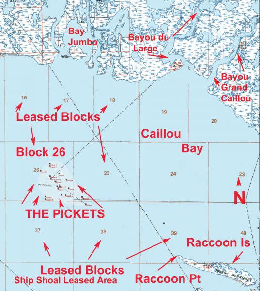
As most know, the owner of the Pickets — Apache Oil Corporation — were in May in the process of removing some of the rig platforms that are no longer producing These platforms are in the Ship Shoal Leased Area, Block 26 area in Caillou Bay.
The federal Bureau of Safety and Environmental Enforcement indicated that Apache has been issued a permit to remove their structures in the Ship Shoal Block 26 area. The company has one year from the expiration of their lease, which was in November 2012, in Block 26 to remove all of their rigs.
Federal law commonly called the “Idle Iron Policy” mandates that companies have to remove their structures when they lose their lease of the site or it is no longer a functioning mineral or gas producer.
Some deviance can be made if the structure remnants are removed to allow a 30-foot clearance below the surface of the water. The Pickets, however, stand in an average of only about eight feet of water.
And in early June, an arrangement between the Louisiana Department of Wildlife and Fisheries and Apache stalled the removal while something is worked out.
Reports from anglers in the area indicated that those platforms that already had been removed had the bottom cleared of all refuse and structures. I don’t doubt that an effort was made to remove the debris, but most often there is something left at the site. It may be only an irregular bottom or a few tools, a battery or even some parts of the structure itself.
With that in mind, I put together some of the locations where the Pickets are or were located. Although most of the sites are in the Ship Shoal Leased Area Block 26, there are a couple in Leased Block 25 just to the east of Block 26 and one in Leased Block 38 to the southeast of Block 26.
The Pickets are west of the Isles Dernieres and most particular Raccoon Island in the Isles Dernieres chain.
Last Islands (Isles Dernieres) are made up of several barrier islands. They are, from east to west, East Island, Trinity Island, Whiskey Island and Raccoon Island.
Raccoon Island is the westernmost of the islands, while Wine Pass on the easternmost tip of East Island at Terrebonne Bay is the easternmost of the islands. These islands stretch more than 20 miles in length.
The westernmost point of Raccoon Island, or what is left of it, is named Raccoon Point. It is in the southern part of Caillou Bay. The westernmost shoal of Raccoon Point is at or about 29° 03.650’ N. Lat. ~ 90° 57.505’ W. long. The eastern tip of EAST Island at Wine Pass is at or about 29° 04.264’ N. lat. ~ 90° 38.095’ W. long.
Erosion has taken its toll on all of the islands. Some might not now even resemble what they looked like a few years ago, so be sure to get a current map before venturing into the area. NOAA Marine Chart No. 11356 Isles Dernieres to Point au Fer and Chart 11352-New Orleans to Calcasieu River-East Section would be the minimum that you should have. In addition to showing the islands, it shows the shoals and drop-offs in the area.
Starting from Raccoon Point and heading west, the bodies of rigs, generally on the same line, are called the Pickets, Mardi Gras and the Blue Points rigs.
Present and past locations of some of the oil and gas wells/platforms in Leased Blocks 25, 26 and 38 in the southern part of Cailloui Bay are commonly called the Pickets. The well sites are numbered in their respective blocks.
The main rig/platform was indicated as being at or about 29° 06.500´ N 091° 03.500´ W and is indicated as my number 26-09 for Block 26 rig # 09.
The others are:
Well Number Latitude/Longitude
25-01 29° 05.847´ N/091° 02.088´ W
25-02 29° 05.796´ N/091° 02.025´ W
26-01 29° 05.909´ N/091° 02.989´ W
26-02 29° 06.232´ N/091° 03.155´ W
26-03 29° 06.232´ N/091° 03.164´ W
26-04 29° 06.268´ N/091° 04.705´ W
26-05 29° 06.529´ N/091° 03.492´ W
26-06 29° 06.500´ N/091° 03.492´ W
26-07 29° 06.529´ N/091° 03.506´ W
26-08 29° 06.546´ N/091° 03.506´ W
26-09 29° 06.500´ N/091° 03.500´ W
26-10 29° 05.835´ N/091° 02.705´ W
26-11 29° 05.913´ N/091° 02.695´ W
26-12 29° 05.924´ N/091° 02.998´ W
26-13 29° 06.436´ N/091° 03.246´ W
26-14 29° 05.917´ N/091° 02.836´ W
26-15 29° 05.916´ N/091° 02.808´ W
26-16 29° 05.840´ N/091° 02.869´ W
26-17 29° 07.033´ N/091° 03.474´ W
26-18 29° 06.660´ N/091° 03.479´ W
26-19 29° 06.746´ N/091° 03.071´ W
26-20 29° 06.515´ N/091° 02.759´ W
26-21 29° 07.115´ N/091° 03.483´ W
26-22 29° 06.193´ N/091° 02.656´ W
26-23 29° 06.266´ N/091° 03.054´ W
26-24 29° 05.875´ N/091° 03.672´ W
26-25 29° 05.797´ N/091° 03.672´ W
26-26 29° 06.849´ N/091° 03.881´ W
26-27 29° 06.264´ N/091° 03.154´ W
38-01 29° 05.595´ N/091° 01.934´ W
All positions are stated as DDD,MM.mmm, and were converted from the Bureau of Safety and Environmental Enforcement format of decimal degrees that were plotted in NAD 27 Datum to the indicated format.
I suggest that you save this information for your trips to that area.
As I said, some of the sites have been removed, but it might pay you in fishing results to know where they were once located.
Write them down and either manually transfer them into your GPS unit or use your manufacturers data transfer program. To use the electronic transfer program, you would type the positions into the program via your computer, and then transfer them all at once as electronic data via the program into your GPS unit. This electronic transfer is the basis of my CAPTAIN PAUL’S FISHING EDGE OF GPS WAYPOINTS.
If there is a demand for these 25 plus positions, I may offer them as an EDGE file.
Capt. Paul