
Hurricane Katrina blew this angler to a landlocked state, but that doesn’t keep him from fishing the marshes of Louisiana.
Dear Capt. Paul:
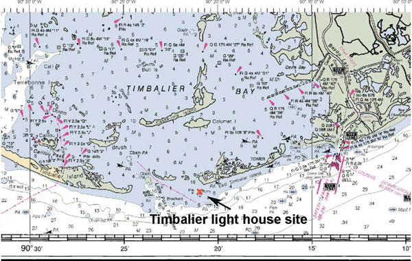
I need the GPS coordinates for Little Pass lighthouse on the west side of Timbalier Island. It was knocked down in a storm in 1985.
Capt. Paul’s response:
The Timbalier Lighthouse site is now only a reef that is described on charts as “ruins.” It is located in about 7 feet of water between Little Timbalier Pass and the western tip of East Timbalier Island. It is farther south in the Gulf of Mexico than the western tip of the island is at or about N29 02.956 x W90 21.354.
In investigating the Timbalier Lighthouse location, I discovered some very interesting facts as detailed below. Based on that information, I suggest that you use the aforementioned position for the lighthouse.
I found some information on the U.S. Coast Guard wives’ web site (www.coastguardwives.com/lighthouse/history/louisiana01.html ) concerning the Timbalier Bay Lighthouse. It is as follows:
On Aug. 3, 1854, Congress appropriated $15,000 “for a light station to mark the entrance to Timbalier Bay and for coast purposes.” The lighthouse was reported completed in 1857.
During the Civil War, the light was discontinued. Upon the occupation of the southern portion of Texas by Union forces in 1864, application was made by the military authorities for the reestablishment of the Timbalier light. Measures were promptly inaugurated to ascertain the condition and necessities of the station, and suitable illuminating apparatus was sent to be put in position when requisite repairs had been completed.
The tower was described in 1867 as built upon a low sand beach near the point of Timbalier Island that, by that year, had been encroached upon by the sea until it was entirely surrounded by water. By February 1867, the tower was in danger of falling, and workmen were sent to take down the lens and establish a beacon on top of the dwelling.
On the 29th and 30th of March 1867, during a storm, the dwelling, together with the tower and everything about the station, was leveled to the ground and covered with 3 to 6 feet of water. The keepers barely escaped with their lives, and lived for some days on an iron can buoy.
Congress appropriated $50,000 for a new lighthouse on March 3, 1869, followed by two similar amounts in 1871 and 1873. A final appropriation of $15,000 was made in 1874. With $120,000 of these appropriations, a new iron screw-pile lighthouse, with focal plane 125 feet above sea level, was completed by January 1875.
The new lighthouse was placed in the water inside the island, which acted as an effective breakwater. The design was a skeleton framework with a spiral stairway, enclosed by sheet iron, giving access to the lantern and provided with a keeper’s dwelling in the lower part of the tower. The lens was a second-order, showing a fixed white light varied by red flashes.
In 1894, the light tower was undermined by the scouring of the channel, and on the morning of Jan. 23, 1894, it canted over. The illuminating apparatus was saved, but was in damaged condition. An attempt was made to take the dismantled tower to pieces and save it, but owing to the inability of the lighthouse tender to approach near enough to the wreck, the work was discontinued and the lighthouse was abandoned.
The lighthouse board decided that requirements of navigation were not such as to justify the rebuilding of the tower, but decided to use instead a lens-lantern light.
The present structure was rebuilt in 1917. It is a white square tower on a wooden dwelling built on piles, and stands in 6 feet of water off the north side of the east end of the island. The light was changed to unwatched operation in 1939, and consisted of an 850-candlepower light that was 56 feet above the water and could be seen 13 miles, flashing white every four seconds. The building is now used as a day beacon.
Using this information about the site, which stated it is now a day beacon, I plotted the position.
The USGS topo quad for that area shows the day beacon to be located concurrently with a USGS bench marker.
The lighthouse was the site for a Geodetic Survey Marker. In 1952, this site had a Geodetic Survey Marker AU2981. The position shows on the topo map at NAD 83(1992): N29 02’ 57.38511” x W090 21’ 21.21055”.
This converts to N29 02.956’ x W90 21.354’(DDD,MM.mmm).
The station in 1952 was described as on the west side of Grand Pass Timbalier, in 6 feet of water, off the north side of the east end of the small island. The station is now a fixed red light in a white square tower on a wooden dwelling on piles, 56 feet above the water.
In 1954, the USGS benchmark description indicated that the site was located on the Gulf of Mexico about 1,400 feet south of a newly formed island lying to the west of East Timbalier Island and about 6,500 feet southeast of the tip of the island.
Unless otherwise specified, all positions are stated as degrees, minutes and thousandths of minutes (DDD,MM.mmm), and were determined using WGS 84 datum. All bearings and courses are stated in magnetic degrees.


