Dear Capt. Paul:
How long has Snake Island in Black Bay been washed away? I looked at some old maps from the late 1990s, but did not see it. Can you help me locate it? GPS coordinates would be great.
Capt. Paul’s response:
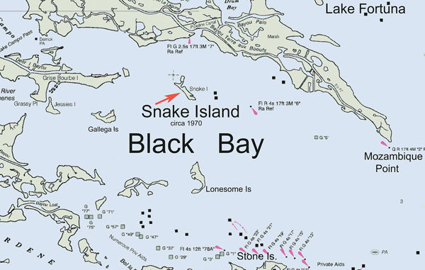
Snake Island has not had land above water since the early 1970s. The island is now only a reef — a dangerous reef, I might add, in that on very low tide you can still see parts of the old concrete seaplane ramp that caused the demise of many a propeller and lower unit.
When we are in the area, we ALWAYS navigate to the north and then west of a production platform that was once actually on the island. We give the site an extra amount of clearance when in the area. I mean by a half of a mile or so distance from the area between the platform and where the reef is located.
Use extreme caution when in the area as there are underwater hazards as well as Christmas tree well heads in the entire area.
If you wish to get an official NOAA chart of the island and surrounding area, go to a contract NOAA Print on Demand dealer and ask for NOAA chart No. 11364/Mississippi River Venice to New Orleans. Ask for the 40th edition released August 2004. Earlier editions may also show the Snake Island location, but my copy of the 2004 edition does have an island designated as SNAKE ISLAND in the Black Bay area. I believe that the 2004 edition is the latest edition released by NOAA. Almost any official NOAA chart dealer, such as Baker Lyman on Veterans Boulevard in Metairie, should be able to provide you with a copy of the chart.
As to specifics for the site: There is now an oil-gas production platform just north of where the reef is located. It is at or about N29 38.573 x W089 34.054. This is a large, usually manned platform well illuminated at night. It is about 1.1 miles at a bearing of 195 degrees from the Aid to Navigation marker Green No. 7 light at the mouth of Bayou Terre Boeufs at Black Bay.
We give at least one half mile clearance to the west of the platform when coming from Bayou Terre Boeufs, and do not turn to course until we are well to the south of its location. It is almost in a direct line on a course from the mouth of Bayou Terre Boeufs at Black Bay to the remnants of Lonesome Island.
The rough north end of the banana-shaped reef that was Snake Island is positioned in a northwest to southeast direction at or about N29 38.456 x W089 34.100. The southeast part of the reef is at or about N29 38.204 x W089 33.818.
Again, use caution and watch for underwater debris and concrete cubes and slabs when in the area.
This is a typical example of why I recommend that GPS users obtain and use software maps that are based on U.S.G.S. topographical maps. Topo maps are updated more often and depict the coastal marshes in more accurate detail than to marine NOAA chart-type maps. NOAA charts are the best in the world for indicating the lights, buoys, cans, nuns and other aid to navigation markers in the area of established commercial marine channels, etc., but they do not always update the land topographical features away from these channels.
Having charts released in 2004 that still show an island that was eroded away in the late 1960s is a prime example of my point. Many of the so-called “marine” charts for GPS units are based on these charts.
Unless otherwise specified, all positions are stated as degrees, minutes and thousandths of minutes (DDD,MM.mmm), and were determined using WGS 84 datum. All bearings and courses are stated in magnetic degrees.


