Skip navigation
CLOSE
X
Search
Subscribe
Back To
Submit Reports
Back To
Log In
Back To
Fishing
Back To
Fishing Articles
See All
Freshwater
Bass Fishing
Inshore
Offshore
Tournaments
Weather
Fishing Reports
Fishing Classifieds
Seasons & Regulations
Hunting
Back To
Hunting Articles
See All
Deer
Waterfowl
Other
Hunting Reports
Hunting Classifieds
Seasons & Regulations
Sportsman Products
Back To
New Products
Weather
Back To
Overview
Tidal Ranges
Lunar Tables
Classifieds
Back To
Classifieds Options
View All
Post Ads
Help
Jump to Section
Golf Carts/ATV
Motors
Boats
Hunting
Fishing
Tractors & Equipment
Real Estate
Vehicles & Trailers
RVs & Campers
Household Items
Businesses
Back To
Businesses
Advertise
Media Kit
Magazine
Back To
Learn More
Contents
Digital Issues
Manage Subscriptions
Purchase Back Issues
Gift Louisiana Sportsman
Subscribe
Back To
Submit Reports
Back To
Log In
Back To
April 18, 2024
Home
/ Listings
Listings
Showing 1–20 of 1799 results
A to Z ( title )
Z to A ( title )
Recently added ( latest )
Date added ( oldest )
Most viewed
Less viewed
Price ( low to high )
Price ( high to low )
Add to Favourites
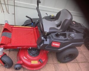
Toro 42″ Zero Turn Mower – Like new <10 hrs.
Top
2 months ago
by A D
Lawn Mower
Brusly
,
Louisiana
$
3,000
Add to Favourites
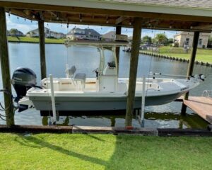
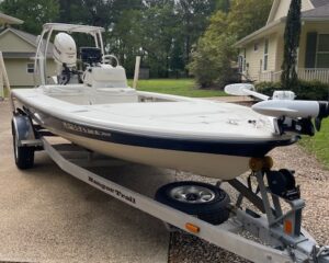
2021 Kencraft Bay Rider 21′–$59,995 OBO
Featured
Top
3 days ago
by The Big Catch
Bay
Slidell
,
Louisiana
$
59,995
Add to Favourites
2008 Champion
New
2 hours ago
by 110prop
Bay
Port Allen
,
Louisiana
$
38,500
Add to Favourites
BERETTA COLLECTORS! 8040 Cougar – NRA # 315 of only 650
New
2 hours ago
by GEORGE SNYDER
Guns
Kenner
,
Louisiana
$
775
Add to Favourites
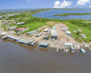
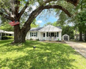
6201 Delacroix Hwy
New
3 hours ago
by The Camp Man
Camps for sale
Denham Springs
,
Louisiana
$
350,000
total price
Add to Favourites
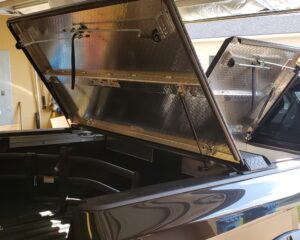
Diamond Back 270 tonneau cover for 2018 Nissan Titan XD with 6’7″ long bed.
New
4 hours ago
by Cary Newnam
Trucks
Lafayete
,
Louisiana
$
1,500
total price
Add to Favourites
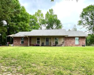
Auto Dealership Buildings/Land/Inventory
New
5 hours ago
by BishopHemphill
Lots for Sale
Brookhaven
,
Mississippi
$
265,000
total price
Add to Favourites
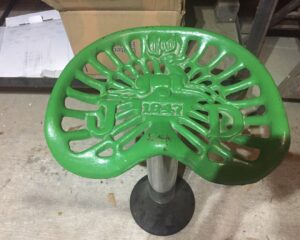
SHOP STOOL
New
6 hours ago
by FRANK FAVALORA
Equipment
Hammond
,
Louisiana
$
55
total price
Add to Favourites
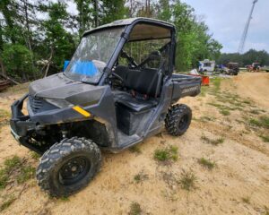
2021 POLARIS RANGER 1000
New
6 hours ago
by Buck Hornsby
Golf Cart/UTV
Clinton
,
Louisiana
$
12,500
Add to Favourites
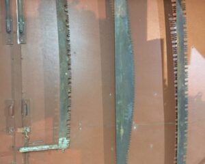
CROSS CUT SAWS
New
6 hours ago
by FRANK FAVALORA
Hunting Equipment
Hammond
,
Louisiana
$
75
total price
Add to Favourites
MILK CAN
New
6 hours ago
by FRANK FAVALORA
Hunting Equipment
Hammond
,
Louisiana
$
65
total price
Add to Favourites
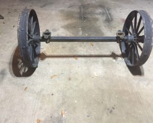
IRON AXLE
New
6 hours ago
by FRANK FAVALORA
Trailers
Hammond
,
Louisiana
$
180
Add to Favourites
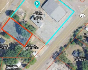
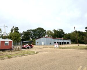
301 DEVEREAUX DR, NATCHEZ, MS *COMMERCIAL* $199,000
New
6 hours ago
by Murray Land and Homes Realty
Homes for sale
Natchez
,
Mississippi
$
199,000
Add to Favourites
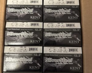
Kent silver steel case
New
6 hours ago
by Damian Fahr
Ammunition
Slidell
,
Louisiana
$
175
Add to Favourites
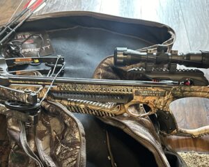
Barnett whitetail hunter II
New
6 hours ago
by Damian Fahr
Bows
Slidell
,
Louisiana
$
375
total price
Add to Favourites
English Springer Spaniel Field and Bench Puppies
New
7 hours ago
by Cyndi Overton
Dogs
Denham Springs
,
Louisiana
$
1,200
–
$
2,000
total price
Add to Favourites
Adm mod 2 13.7 p&w
New
20 hours ago
by Micheal Beasly
Guns
Lafayete
,
Louisiana
$
2,500
total price
Add to Favourites
BoykinDoodles
New
21 hours ago
by philjase
Dogs
Madison
,
Mississippi
$
500
Add to Favourites
203 BROOKLYN DR, NATCHEZ, MS – $120,000
New
1 day ago
by Murray Land and Homes Realty
Homes for sale
Natchez
,
Mississippi
$
120,000
Add to Favourites
172 BUFFALO RD, WOODVILLE, MS – $220,000
New
1 day ago
by Murray Land and Homes Realty
Homes for sale
Natchez
,
Mississippi
$
220,000
Add to Favourites
168 Ranger Phantom
New
1 day ago
by Roy Koch
Fishing
Covington
,
Louisiana
$
31,123
Add to Favourites
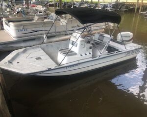
2000 Predator Center Console 18ft Bay Boat with 2019 115 Evinrude Etec and Trailer
New
1 day ago
by CHAD SIMMONS
Bay
Hammond
,
Louisiana
$
10,500
1
2
3
4
…
88
89
90
Log in to post your ad
Search Listings
Search
Filter
Category
Location
Price Range
Apply filters