Skip navigation
CLOSE
X
Search
Subscribe
Back To
Submit Reports
Back To
Log In
Back To
Fishing
Back To
Fishing Articles
See All
Freshwater
Bass Fishing
Inshore
Offshore
Tournaments
Weather
Fishing Reports
Fishing Classifieds
Seasons & Regulations
Hunting
Back To
Hunting Articles
See All
Deer
Waterfowl
Other
Hunting Reports
Hunting Classifieds
Seasons & Regulations
Sportsman Products
Back To
New Products
Weather
Back To
Overview
Tidal Ranges
Lunar Tables
Classifieds
Back To
Classifieds Options
View All
Post Ads
Help
Jump to Section
Golf Carts/ATV
Motors
Boats
Hunting
Fishing
Tractors & Equipment
Real Estate
Vehicles & Trailers
RVs & Campers
Household Items
Businesses
Back To
Businesses
Advertise
Media Kit
Magazine
Back To
Learn More
Contents
Digital Issues
Manage Subscriptions
Purchase Back Issues
Gift Louisiana Sportsman
Subscribe
Back To
Submit Reports
Back To
Log In
Back To
April 25, 2024
Home
/ Listings
Listings
Showing 1–20 of 1792 results
A to Z ( title )
Z to A ( title )
Recently added ( latest )
Date added ( oldest )
Most viewed
Less viewed
Price ( low to high )
Price ( high to low )
Add to Favourites
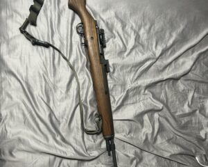
M1A (A.K.A M14) with a Steel Springfield Rail mount for Scope and Hard Case
Featured
Popular
Top
4 months ago
by Jules Martin
Guns
Chalmette
,
Louisiana
$
2,200
total price
Add to Favourites
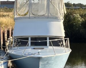
Aluminum 36’ Sportfish no engines
Featured
Popular
Top
1 month ago
by Avery Munson
Other Boats
New Iberia
,
Louisiana
$
23,500
total price
Add to Favourites
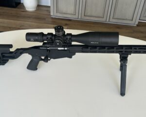
Ruger Precision Rimfire 22lr
New
37 mins ago
by Ben Adams
Guns
Houma
,
Louisiana
$
800
total price
Add to Favourites
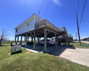
REDUCED 122 Norah Lane, Grand Isle, LA 985-787-3200
New
3 hours ago
by Coastal Realty
Camps for sale
Grand Isle
,
Louisiana
$
315,000
Add to Favourites
SADDLE KING OF TEXAS STAMPED LEATHER WESTERN SADDLE
New
4 hours ago
by Jessica Cason
Sports & Camping Equipment
Baton Rouge
,
Louisiana
Add to Favourites
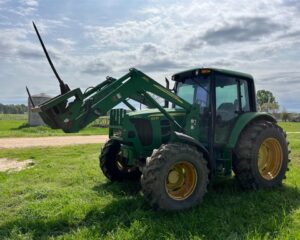
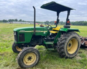
JOHN DEERE 6330 FARM TRACTOR
New
4 hours ago
by Jessica Cason
Tractors
Livingston
,
Louisiana
Add to Favourites
2019 YANMAR SA24 FARM TRACTOR WITH FRONT LOADER AND BACKHOE
New
4 hours ago
by Jessica Cason
Tractors
Livingston
,
Louisiana
Add to Favourites
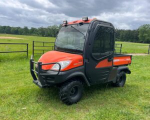
2014 KUBOTA RTV 110 4X4 UTILITY VEHICLE | NO TITLE
New
5 hours ago
by Jessica Cason
ATVs & Four Wheeler
Baton Rouge
,
Louisiana
Add to Favourites
2009 JOHN DEERE GATOR XUV | NO TITLE
New
5 hours ago
by Jessica Cason
ATVs & Four Wheeler
Baton Rouge
,
Louisiana
Add to Favourites
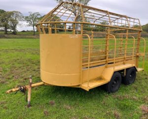
TANDEM AXLE BUMPER PULL STEEL HORSE TRAILER | NO TITLE
New
5 hours ago
by Jessica Cason
Trailers
Baton Rouge
,
Louisiana
Add to Favourites
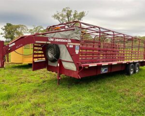
2014 GOOSENECK STOCK TRAILER
New
5 hours ago
by Jessica Cason
Trailers
Baton Rouge
,
Louisiana
Add to Favourites
1994 JOHN DEERE 650G SERIES IV DOZER WITH WINCH
New
5 hours ago
by Jessica Cason
Equipment
Baton Rouge
,
Louisiana
Add to Favourites
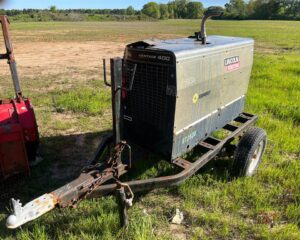
2014 LINCOLN VANTAGE WELDER | NO TITLE
New
5 hours ago
by Jessica Cason
Equipment
Baton Rouge
,
Louisiana
Add to Favourites
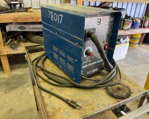
CHICAGO ELECTRIC 90AMP FLUX WIRE WELDER AND CART
New
5 hours ago
by Jessica Cason
Equipment
Baton Rouge
,
Louisiana
Add to Favourites
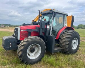
MASSEY FERGUSON 4263 TRACTOR WITH SIDE MOWER
New
5 hours ago
by Jessica Cason
Tractors
Baton Rouge
,
Louisiana
Add to Favourites
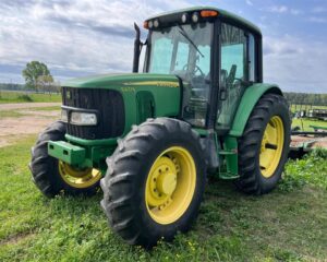
JOHN DEERE 6420 FARM TRACTOR
New
5 hours ago
by Jessica Cason
Tractors
Baton Rouge
,
Louisiana
Add to Favourites
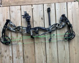
Hoyt RX-1
New
Featured
5 hours ago
by Texan1894
Bows
Baton Rouge
,
Louisiana
$
700
total price
Add to Favourites
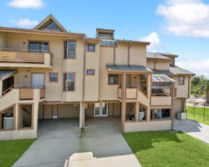
Waterfront Condo For Sale
New
Featured
Top
6 hours ago
by Nicole Schlaudecker
Homes for sale
New Orleans
,
Louisiana
$
149,000
Add to Favourites
JOHN DEERE 5303 FARM TRACTOR
New
6 hours ago
by Jessica Cason
Tractors
Baton Rouge
,
Louisiana
Add to Favourites
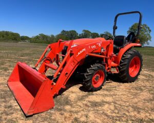
KUBOTA L3301D FARM TRACTOR
New
6 hours ago
by Jessica Cason
Tractors
Baton Rouge
,
Louisiana
Add to Favourites
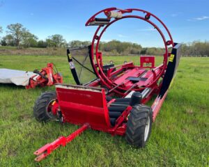
2013 ANDERSON NWX-660 X TRACTOR BALE WRAPPER
New
6 hours ago
by Jessica Cason
Equipment
Baton Rouge
,
Louisiana
Add to Favourites
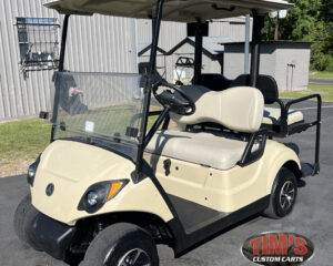
2019 Yamaha Drive2 Gas EFI Sunstone Golf Cart
New
8 hours ago
by TIM'S CUSTOM CARTS
Golf Cart/UTV
Lafayete
,
Louisiana
$
6,039
total price
1
2
3
4
…
88
89
90
Log in to post your ad
Search Listings
Search
Filter
Category
Location
Price Range
Apply filters