I frequently get questions why a reader can’t find a stated position or a position a friend provides or why their GPS position information is not the same as their friends when both units are at the same position.
Many times it is because of an incorrect datum setting.
Yes, datum settings in your GPS can be critical. No, I don’t mean data or day time: I mean datum.
So, what is datum?
Webster defines it as something used as a basis for calculating or measuring reference.
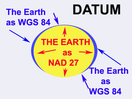
In layman’s terms it is a reference to navigation datum that is the map maker’s shape of the earth, a nice clean mathematical ellipsoid of the surface of the earth.
Prior to satellite measurements, they were based on what the map makers thought was the shape of the earth. As with any type of map, this position setting begins surveying from a specific point. Large areas take into consideration the curvature of the earth in these calculations based on what they believed was the curvature of the earth.
Various regions of the world selected an ellipsoid that best approximated their portion of the earth, taking into account the local topography of the mapped area.
Before satellites, surveying was done on the ground and later by using photos taken from airplanes. These surveys were carried out by people on the ground using transits and distance-measuring chains or rods as there basic go-to means of recording distances.
They started with a known position, according to their determined datum and used it to locate other features.
One can only imagine the difficulties of stretching out a rod of linear measure equal to 5½ yards or a chain of connected rods equaling about 66 feet.
It is not the best means of connecting the different positions on a map, especially in a mountainous forested or swampy area. But this was the standard based on a datum.
The United States Coast and Geodetic Survey in 1901 adopted a national horizontal datum called the United States Standard Datum based on the Clark Ellipsoid of 1866 and measured from Meades Ranch, Kan.
Canada and Mexico adopted this datum in 1913, and it was renamed North American Datum. In 1927 it was again renamed as NAD 27.
As space-based surveying came into use, a standardized datum based on the center of the earth and an ellipsoid that was a good fit to the entire surface was developed. NAD 83 is a datum in this category.
These satellite measurements were offered to the rest of the world and is called World Geodetic System of 1984.
The global positioning system in which the satellites are placed in orbit use earth-centered datum or World Geodetic System 1984 or WGS 84.
WGS 84 was adopted as a world standard from a datum called the North American Datum of 1983 or NAD 83.
There is typically only a meter or 2 difference between WGS 84 and NAD 83 in the continental United States. But the difference between WGS 84 and NAD 27 can be as much as 200 meters.
To accommodate these different measurements, most GPS units have a selection of over 100 datums, listed by the area they represent.
Most maps for the U.S. use the common NAD 27 CONUS – North American Datum of 1927 for the continental United States (common on older USGS maps). Newer maps might use NAD 83 or even WGS 84 datum.
Recent maps and charts use WGS 84. But use caution because I have seen some units with some weird datum settings. An incorrect datum can put you hundreds of meters from your actual position.
The datum you have set up in your GPS receiver should match that used to create the map you are using.
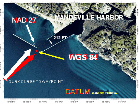
Datum is a very important component of a coordinate. The difference between a position stated in NAD 27 and one stated in WGS 84 is about 265 feet.
That might not be critical in finding an offshore oil and gas platforms, but you would certainly have a problem finding an artificial underwater reef or your friend’s honey hole — or, heaven forbid, the mouth of a jetty or break water in bad weather.
By the way, the official offshore government list most of the offshore oil and gas platforms in NAD 27 and use a decimal degrees position format. (NAD 27 and DDD.dddddd)
So when entering a position, ask not only for the position format, but also ask for the datum used to plot the position information.
If they don’t know, take the information but use it with suspicion.
If they do know but it is different from the one you are using, simply change the datum setting in your GPS unit and enter the new position, and then change back to the datum you normally use.
Or, you can use one of the tools at www.ngs.noaa.gov/TOOLS/Vertcon/vertcon.html to convert the datum.
Most GPS units that can use the wide area augmentation system (WAAS) that can determine a position to within 3 meters.
But it pays you to use the correct datum settings in order to get the most out of your GPS unit.

")
