Capt. Paul shares coordinates for Lake Borgne and Bay Eloi
Dear Capt. Paul:
I am looking for coordinates of shell pads that might exist in Lake Borgne and around Bay Eloi.
Any old rig pads, old islands or points, etc. would be great.
Thanks.
Capt. Paul’s response:
I have most, if not all, of the old gas well sites in Lake Borgne in my Captain Paul’s Fishing Waypoints of GPS Positions listed in my Lake Borgne file, and many of the Bay/Lake Eloi rigs in the Hopedale MRGO to Mississippi Sound Edge programs.
These are available exclusively on the Louisiana Sportsman Outdoor Store at www.4Sportsman.com.
I will, of course, provide you with some of the requested items now, but you can find many of these sites on your own.
The Louisiana Department of Natural Resources has a website that lists all past and present oil, gas and water wells in the state. The site is called SONRIS (http://sonris-www.dnr.state.la.us/www_root/sonris_portal_1.htm), and it includes a database of sites that allow you to access information in a variety of ways that include a general map of the area and breakdowns by parish, by gas or oil field name, well number and or name, and by operator.
It is a very good resource for anglers and hunters.
Note that SONRIS positions provided are stated in decimal degrees (h, DDD.ddddddd) and were determined using NAD 27 Datum.
So if your are entering the data in your GPS unit, change the position format and datum settings in your GPS unit to the aforementioned settings, and then change back to your normal position and datum settings after entering the coordinates.
The SONRIS program indicates removed wells as a “well hole — not operating.”
It is a very useful program to find the shell or gravel pads that were once installed around the well sites. As you know, these “pads” often offer ideal fishing habitat.
And, yes, I know the owners are required to clean up the sea floor around their well sites when the platforms are removed, but such cleaning often leaves the sea floor rough and with evidence of such cleaning. These areas are different from the normal sea floor and, as such, usually attract sea creatures.
My Lake Borgne Edge file has more than 160 waypoints in and around the lake, many of which are present and past well sites. The Hopedale/MRGO to Mississippi Sound file has more than 310 waypoints in your requested area.
Captain Paul’s Fishing Edge is a unique program that can be downloaded directly into various GPS units from manufacturers’ mapping program or via several other mapping and data-transfer programs.
This technology saves countless hours of manually entering each waypoints into GPS receivers. The entire procedure of loading more than 150 waypoints from a typical Captain Paul’s Fishing Edge file takes less than five minutes.
I believe these files give anglers and hunters an advantage in getting to, finding fishing spots, moving around and getting back from some of the more-popular areas in the state.
Presently, I have 21 Captain Paul’s Fishing Edge files:
• Hopedale/MRGO to the Mississippi Sound
• Lake Borgne
• Hopedale to Bayou Terre Boeufs
• Delacroix to Point a la Hache
• Bayou Bienvenue
• Port Sulphur
• Lake Calcasieu
• Lafitte
• Leeville East
• Leeville-West
• Lake Pontchartrain
• Myrtle Grove-Lake Hermitage
• Empire to Buras
• Pearl River WMA
• Vermillion Bay
• Cocodrie/Dulac
• The Rigolets
• MRGO dam and markers
• Bayou Sauvage NWR
• Big Branch NWR
• Lake Borgne
Program files are designed for Garmin, Magellan, Lowrance, Delorme, RayMarine, Hummingbird, units, among others that require a GPX data exchange protocol and their mapping programs.
Edge files are not interchangeable.
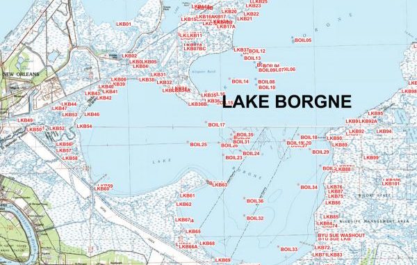
I have designated these positions in my Edge file as waypoint numbers beginning with “BOIL,” which represents “Lake Borgne Oil sites.
Here are some of these sites:
• BIOL 27 —29°59.045’ N. Latitude ~ 89°37.252’W. Longitude
• BOIL 28 — 29°57.723’ N. Latitude ~ 89°35.150’ W. Longitude
• BOIL 38 — 30°00.709’ N. Latitude ~ 89°43.055’ W. Longitude;
• BOIL 39 — 29°56.545’ N. Latitude ~ 89°42.475’ W. Longitude;
• BOIL 36 — 29°55.852’ N. Latitude ~ 89°40.195’ W. Longitude;
• BOIL 39 — 29°56.545’ N. Latitude ~ 89°42.475’ W. Longitude;
Bay Eloi sites include:
• Hedge 16 — 29°46.154’ N latitude ~ 89° 20.423’ W. Longitude
• Hedge 17 — 29°45.150’ N latitude ~ 89° 22.541’ W. Longitude
• Hedge 25 — 29°46.095’ N latitude ~ 89° 22.756’ W. Longitude
• Hedge 32 — 29°44.993’ N latitude ~ 89° 22.501’ W. Longitude
• Hedge 49 — 29°44.852’ N latitude ~ 89° 22.987’ W. Longitude
• Hedge 50 — 29°45.264’ N latitude ~ 89° 23.788’ W. Longitude
In both of these areas, always try the small “Christmas tree” platforms. They might not hold as many fish, but those fish that are there are usually larger.
Unless otherwise specified, all positions are stated as degrees, minutes and thousandths of minutes (DDD,MM.mmm) and were determined using WGS 84 Datum.
All bearings and courses are stated in magnetic degrees.
Capt. Paul
