Dear Capt. Paul:
In several of your articles I have read, you mentioned that the GPS coordinates were in NAD 27. I have a Garmin mapping program and in the properties are 11 NAD 27 settings. Would you be referring to NAD 27 Central?
I know this is a stupid question , but I just want to be sure and not assume anything.
Rk
Capt. Paul’s response:
Your question in not unusual, nor is it a dumb one. Most people just enter a coordinate in what ever DATUM format is in their GPS unit or in their mapping program.
By asking the question, it puts you in the group of people who want to take advantage of the new-found accuracy that is now available in the updated Global Positioning System.
New GPS units that can receive the newly activated WAAS differential satellite transmissions can produce a position that has an accuracy that is usually within 3 meters (9.8 feet). This accuracy was unheard of just a few years ago.
Why have this accurate GPS instrument and not take advantage of its capabilities by having incorrect or improper settings? It is to your advantage to make the most out of what your GPS unit can do.
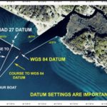
Using an incorrect datum can shift a position as much as five miles from the actual position. That is why some users cannot locate a position they obtained from a friend or published source: The datum that they are using in their GPS unit is different from the datum used to plot or capture the position.
Possibly not realizing the importance of having the correct datum, they think the information was incorrect or as one reader put it, “ I was given wrong information.”
I was able to prove otherwise. The reader simply assumed that the datum he was provided was what he was using in his GPS unit. Once an explanation was offered, a correction in his settings yielded the correct position.
Now back to your question! The NAD 27 datum you should use for all Louisiana positions that require a NAD 27 datum should be NAD 27 CONUS.
The CONUS is a sub section of NAD 27 that is specifically for the continental United States.
NAD 27 Central, on the other hand, is for those positions in Central America.
The difference between two of the most-common datum used in our area, NAD 27 (CONUS) and WGS 84, can be as much as 250 feet.
Yes, I know that this is not a lot of an error if you are heading for an offshore oil platform that is seven stories high and over 400 by 600 feet in length and width — the difference of 200 feet will not matter.
But if you had the mouth of a pass that was between two jetties plotted and you were off by 200 feet you could wind up, both figuratively and literally on the rocks.
And you certainly would not be able to find those underwater features such as artificial and natural reefs, wrecks, sea bottom holes, your hunting stand, the boundaries of your lease or any other plotted position that is not readily visible.
To eliminate this inaccuracy in determining the actual position, a GPS user should always try to determine the datum that was used to capture or plot a published position.
Most GPS units come with a default datum set to WGS 84. However, many positions are published using some of the other common datum.
For instance all of the offshore platforms are recorded by the Department of the Interior using NAD 27 (CONUS) datum. You can find it on their web site by searching the Fast Facts -Platform Structures at www.data.boem.gov/homepg/data_center/platform/platform/master.asp
The Louisiana Department of Wildlife mainly uses the NAD 83 datum, which is basically the same as WGS 84, for its reefs and other published sites.
If your friend or a published source located and marked the positions using one datum, you should use that same datum to enter the position in your GPS unit.
Simply obtain the datum he used or what the datum was when he captured the positions, and using the menu screen, change the datum in your unit to match the datum he used.
Enter the datum, and then reconfigure your unit back to the datum you normally use.
All of his waypoints will then be in your unit, converted to read the position as per the datum that you are using. The latitude and longitude will be numbered differently from the positions he gave you, but the positions will be the same when using your normal datum.
You should do the same when using a Garmin mapping software, or their Base Camp or Home Port in your computer.
Determine the datum used to capture or plot the position and go to the Edit button at the top of the program. Then select Preferences and the Position tab of the drop down menu.
Once there, note the datum listed in the small datum window. Select the one that is appropriate for your waypoints. Enter your positions used the known datum, and then change the datum back to the one you normally use in your GPS unit.
You will note that the positions have remained the same on the maps, but that the values for the latitude and longitude have changed to reflect the different datum setting.
If the datum is of unknown origin, don’t simply discard the information; enter using you default datum, but treat the position with suspicion.
When I get such unknown datum positions, I select a unique character or icon to represent the name for the position or symbol for the position. Something like a plus and or minus in the name of the position such as “4 bayou + -“ or a unique icon for the location. There are almost a hundred different icons you could use to designate the fact that the datum was unknown.
Then, when in the area of the position, use your GPS to explore and correct any errors you might find. If the positions are hidden, such as those underwater, and if you can’t find the position, change the datum and reenter the values using a new datum. Then Go To the location. It may take a few attempts, but if the position is important, you can refine the actual values.
If the positions are on land, you can use the Garmin mapping and data transfer programs to refine the position. I use Maptech Terrain Navigator Pro to plot such locations then transfer the locations to the GPS receiver.
Feel free to contact me if you need any additional assistance or if you have some positions you need plotted.
Capt. Paul


