A lesson on finding productive fishing
Dear Capt. Paul:
I am told that there were several oil platforms, old well heads and/or other oil-field sites within the Tiger Shoal area that have been removed in years past.
I am interested to know if you have the coordinates for some of these sites and their removal dates(or estimated dates)? My reason is that I’m assuming there is still some sort of rock or shell pad left behind that might be good for fishing.
— Thank you,
M-12
Capt. Paul’s response:
Wow! M-12, you are asking for detailed positions of over 200 well sites/platforms in the Tiger Shoals area.
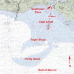
This shoal area is about 10 miles south-southwest from the Southwest Pass of Vermillion Bay at a bearing of 201 degrees magnetic. It is a shoal area that appears on maps as a large banana laying in an east-to-west position.
There are numerous well sites, as well as wrecks and underwater mounds throughout the area.
I do not have the time nor the space to adequately provide you with all of the information you need, but I will provide some of the major sites and steer you in a direction that you can obtain all of the information you need.
The United States coastline is divided into areas that are called leased block areas. These areas are usually named for a feature along the coast or an underwater geological feature. These leased areas are then divided into blocks, each of which is usually rectangular in shape and specified by latitude and longitude using North American Datum of 1927.
Yes, I know, the current World Geodetic System of 1984 (WGS 84) datum is more accurate, but the leases were determined years ago using the older NAD 27 datum. I was told by U.S. Department of the Interior’s Bureau of Ocean Energy Management, Regulation and Enforcement people that it would be a nearly impossible task to amend all of the hundreds of thousands of leases with the WGS datum.
New leases are now plotted in both NAD 27 and WGS 84 Datum.
As there are no sign posts in offshore waters, specific areas are called by their leased area and block number, such as Vermilion 50, meaning block 50 in the Vermilion Bay area.
First you will need a rough idea where these different sites are located. By that I mean in which of leased blocks your quests are located.
The location of the specific block number in the leased area will put you in the general area where the platforms are located. The government then conducts lease sales for the right to explore and produce minerals from these lease blocks.
All platforms are required to be listed by BOEMRE, the federal repository for lease data, and the exploration and production information for these areas. It is like a general grid system that will at least get you close to the area of your concern. They keep current and past well sites in a very detailed format.
The genesis of your search should start with the maps or charts that show these leased blocks. NOAA Marine Chart 1116A Leased Block for the Mississippi River to Galveston, Texas, shows the BOEMRE leased areas and blocks within those areas.
For those of you who fish the mouth of the Mississippi River eastward, get NOAA Marine Chart 1115A Leased Block for Cape St. George, Fla., to Mississippi River Passes.
After locating the leased block areas in which you are interested, you should also get a copy of the latest NOAA chart for the specific area in 1:80,000 scale.
The Tiger Shoals area is shown on NOAA Marine CHART 11349-Vermillion Bay and Approaches. This chart will show individual platforms, underwater mounds, wrecks and other navigation features. The chart also shows underwater pipelines designated by a series of dots followed immediately with a small line.
When getting these charts, be sure to get the latest version. But historic charts created 10 years or so age would also be a great value to you, as they would show wells/platforms as they were then.
Almost any NOAA contract chart mapping service that has a print-on-demand service should be able to provide you with these charts.
You can then access the Management, Regulation and Enforcement website at http://www.data.boem.gov/homepg/data_center/platform/platform/master.asp, and search by leased area, by leased block and well number or well name. You can even search for the date when the well was closed or removed.
By noting the leased areas, you can select a specific area and even individual blocks existing leases and or platforms. This program is a very valuable tool for the offshore fisherman.
After defining the area/block you are interested in the program will display all of the platforms in that area or block. They mostly just have a number of the platform, but sometimes indicate the common or given name of the facility, i.e., Brutus, Ram Powell, etc. Position figures are usually stated in decimal degrees determined by using NAD 27 datum.
Once you have these positions, you can then enter them manually into your GPS unit.
Again, remember that the position format in your program or GPS unit, must agree with the MMS format or you must convert the decimal degrees into the format used in your unit or temporarily change the position format in your GPS unit to decimal degrees and NAD 27 datum. Then enter the positions, and change the position format and datum back to the one that you normally use. The internal GPS software will do the conversion for you. This is extremely important when trying to find an underwater site that has no surface landmark.
By selecting the specific areas, you will have all of the existing or removed platforms in that leased block
I have taken the opportunity to plot some of the over 200 rigs and platforms in the area you indicated.
Most of the platforms are or were located in North Marsh Island blocks 208, 209, 210, 212, 230, 231, 232, 234, 235, 236, 237 and 239, and Vermilion blocks 30, 31,33, 50, 51, 52, 53, 69, 70 and 71.
As previously stated, the area is crossed with numerous pipelines that also offer fishing structure. These pipelines are shown in the Vermillion Bay Approaches chart.
Here are some of the wells and other hazardous objects in the Tiger Shoal. The names of the sites indicate the feature available for fishing.
Name Latitude Longitude
Mound 01 29° 26.4423´ N 092° 06.2012´ W
Mound 02 29° 25.6454´ N 092° 05.6919´ W
Mound 03 29° 25.2642´ N 092° 06.2803´ W
Mound 04 29° 24.9089´ N 092° 06.7305´ W
Mound 05 29° 24.5624´ N 092° 06.9185´ W
Mound 06 29° 24.3068´ N 092° 06.8940´ W
Mound 07 29° 23.8647´ N 092° 06.7358´ W
Mound 08 29° 23.3362´ N 092° 07.1958´ W
Mound 09 29° 23.0718´ N 092° 07.2305´ W
Tiger 01 29° 26.8278´ N 092° 11.6187´ W
Tiger 02 29° 26.9014´ N 092° 11.7817´ W
Tiger 03 29° 26.8883´ N 092° 11.5396´ W
Tiger 04 29° 26.9187´ N 092° 10.3965´ W
Tiger 06 29° 26.6199´ N 092° 10.5898´ W
Tiger 07 29° 26.7021´ N 092° 10.1196´ W
Tiger 08 29° 26.3384´ N 092° 11.7026´ W
Tiger 09 29° 26.0828´ N 092° 11.5298´ W
Tiger 10 29° 25.9745´ N 092° 11.2822´ W
Tiger 11 29° 26.2733´ N 092° 10.1294´ W
Tiger 12 29° 26.5203´ N 092° 09.0806´ W
Tiger 13 29° 26.0741´ N 092° 09.5410´ W
Tiger 14 29° 26.7802´ N 092° 04.7271´ W
Tiger 15 29° 26.9534´ N 092° 04.8853´ W
Tiger 17 29° 27.0312´ N 092° 04.8359´ W
Tiger 18 29° 26.7931´ N 092° 04.8457´ W
Tiger 19 29° 26.7844´ N 092° 04.5044´ W
Tiger 20 29° 26.8927´ N 092° 04.6924´ W
Tiger 21 29° 26.5852´ N 092° 04.7915´ W
Tiger 22 29° 26.2733´ N 092° 04.7964´ W
Tiger 23 29° 26.0741´ N 092° 05.1079´ W
Tiger 24 29° 26.3470´ N 092° 05.1523´ W
Tiger 25 29° 26.0698´ N 092° 06.3301´ W
Tiger 26 29° 26.3773´ N 092° 04.1431´ W
Tiger 27 29° 26.4727´ N 092° 03.7080´ W
Tiger 28 29° 26.8711´ N 092° 03.9355´ W
Tiger 28 29° 26.6459´ N 092° 04.0146´ W
Tiger 29 29° 27.1829´ N 092° 03.4014´ W
Tiger 30 29° 27.8237´ N 092° 04.2520´ W
Tiger 31 29° 26.8104´ N 092° 03.3418´ W
Tiger 33 29° 27.7112´ N 092° 03.7476´ W
Tiger 34 29° 28.8455´ N 092° 04.0542´ W
Tiger 35 29° 27.9883´ N 092° 03.1440´ W
Wreck 01 29° 26.4769´ N 092° 04.4995´ W
Wreck 02 29° 24.2634´ N 092° 01.0312´ W
Wreck 03 29° 27.9796´ N 092° 05.0142´ W
Wreck 04 29° 23.4315´ N 092° 06.6963´ W
Wreck 05 29° 28.4905´ N 092° 06.6860´ W
Wreck 06 29° 22.5908´ N 092° 03.7178´ W
Wreck 07 29° 28.5511´ N 092° 07.5767´ W
Unless otherwise specified, all of my positions are stated as Degrees, minutes and thousandths of minutes (DDD,MM.mmmm) and were determined using WGS 84 datum. All bearings and courses are stated in magnetic degrees and statute miles.
— Capt. Paul
