
Dear Capt. Paul:
Have you ever heard of a fishing place called Baldwin Lodge? It is somewhere near the Polecat Bend, wherever that is located. I believe that it is somewhere in Lake Pontchartrain.
— Tommy BAT
Capt. Paul’s response:
Yeah, I heard the posting by several guides about the fishing conditions around Polecat Bend, and I am able to give you some of the information about both of the locations.
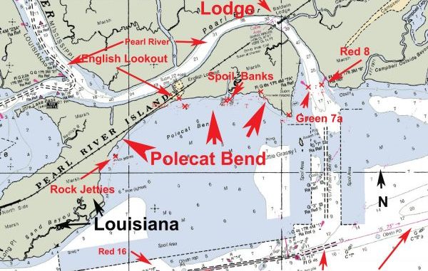
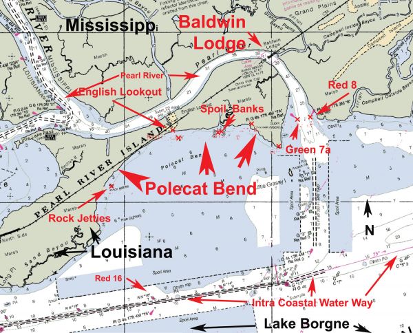
First, both locations are in the northern part of Lake Borgne between and on the mouth of Pearl River and Long Point.
Polecat Bend
The Polecat Bend is the entire area that forms a banana-shaped coastline about two miles due north of the light marked as Green No. 15 and the buoy Red No. 16 of the Intracoastal Waterway.
It is the southern area of Pearl River Island. There are numerous locations that draw and hold fish along the “bend.” On a map of the area you will note several of these locations.
On the western end of the bend there is the mouth of a bayou named Redfish Bayou, which is located at or about 30° 09.4879’ N ~ 89° 34.5683’ West and a place called the Rock Jetties at or about 30°10.1887’N ~ 89°34.1792’ W.
Farther to the east is a site where there are three pilings. The center piling is located at or about 30°10.7521’N ~ 89°33.2651’ W. North of the pilings is the area where a small, unnamed bayou enters the lake.
This is called English Lookout. Continuing eastward for about .7 miles, there are two small spoil areas that are out from a canal and King Bee Bayou.
The western most is at or about 30°10.8190’ N ~ 89°32.7329’ W and the eastern one about 30°10.8347’ N ~ 89°32.6836’ W .
Down the coastline to the east is the mouth of a small bayou which is at or about 30°10.9238’ N ~ 89°32.2769’ W,
By now you are near the point at Pearl River at or about 30°10.6604’ ~ 89° 31.9077 W. It is just to the west of the Pearl River.
There are two NOAA aids to navigation (NAVAIDS) lights with radar reflectors: one on each side of the channel, which is supposed to be kept to a depth of 6.5 feet all the way to the Intracoastal Waterway.
These Pearl River NOAA lights Green No. 7A on the Louisiana side is located at or about 30°10.9730’ N ~ 89° 31.6523’ W and Red light at or about 30° 11.0022’ N ~ 89°31.4771 W on the Mississippi state side.
Use caution when fishing this area, as you will be on the Louisiana/Mississippi border. So, please have the necessary fishing licenses for this area.
Baldwin Lodge
Once at the Pearl River, you are a stone throw from these lights to the area called Baldwin Lodge. It is the location where the lodge used to be.
Look for a ridge line of trees on the Mississippi side of the Pearl River next to and south of the rail road. It is about one mile at a heading of 339 degrees magnetic from the aforementioned channel marker lights.
NOAA listed historical data for Baldwin Lodge as being in Hancock County, Mississippi. It is described as being on the Pearl River at the CSX railroad line and one meter above sea level.
The Baldwin Lodge was on the Pearl River where Grand Plains Bayou and Campbell Inside Bayou enter the Pearl River, with a position at or about 30° 11.7336’ N. 89° 31.933’ W. It is marked so on NOAA chart 11367, Waveland to Catahoula Bay, but it is not shown as such on all maps.
The Baldwin Lodge and English Lookout are sites steeped in history.
English Lookout, which is in St. Tammany Parish basically in the center of Polecat Bend, was given this name during the War of 1812 because Pearl River Island served as a British encampment.
Gen. Andrew Jackson passed through the area a month before arrival of the British. In an attempt to locate the American army, the British landed thousands of their troops on the island.
They embarked in a driving, freezing rain to begin their search, but they only found hibernating alligators. To make conditions worse, they could not find any dry fuel in the area for their campsites or stoves.
These conditions forced them to leave many of their comrades frozen in the swamp and proceed to Chalmette, where they finally met Gen. Jackson at the Battle of New Orleans.
Baldwin Lodge began as a holding station for the passengers on the Louisville/Nashville (now the CSX) railroad line.
It seems there was nearly a battle between the Louisiana and Mississippi around 1882 because of an effort to prohibit the spreading of small pox and yellow fever which was prevalent in the area at that time.
A quarantine inspection station was set up at the junction of the Pearl River and the L&N railroad site on the Louisiana side, and the lodge was built on the Mississippi side of the Pearl River.
The Louisiana State Board of Health in their biennial report of the Board of Health about 1882/84 stated to all agents and conductors that, “They were to watch for all strangers and suspicious persons, and where tickets are sold for getting on trains, counting the persons getting on trains compared to the tickets sold, and notify the conductor of this. Agents will ask all suspicious persons if they are from Pensacola …”
Again use caution when fishing this area, as you will be on the Louisiana/Mississippi border to ensure you have the necessary fishing licenses.
Be prepared for any type of fish in the area, from freshwater catfish and bass to specks, reds, flounder, tripletails and many other saltwater fish. This location is an excellent location to fish, especially when the wind is coming off of the land to the south or southeast.
All positions were determined using WGS84 Datum and are expressed in a position format of Degrees, minutes and thousandths of minutes (DDD,MM.mmm)
Good Luck! Keep in touch and let me know how you made out.
– Capt. Paul