Coastline is shifting inland, challenging communities to adjust
It’s already happening. Right now. Low-lying areas along the coast are disappearing and exposing what sits behind to the Gulf of Mexico, which continues pushing further into Louisiana with each passing year. To put it another way, in terms that should sound familiar, the bottom boundary of the state is vanishing and being recreated.
Just a few months ago, officials at the National Oceanic and Atmospheric Administration erased 31 locations in Plaquemines Parish off of their maps, including Yellow Cotton Bay, English Bayou, Locust Pond and Pass de Wharf, among many others.
On Isle de Jean Charles, sandwiched between Bayou Terrebonne and Pointe-aux-Chene, locals are tearfully predicting a similar fate. Over the past few decades, the island has been repeatedly described as fragile by scientists and residents alike. Today, it’s well beyond that. Sure, it has a levee that eclipses six feet or so, but it’s little protection against a nine-foot storm surge like Hurricane Ike churned up.
Members of the Biloxi-Chitimacha-Choctaw Indian tribe, staples of the local community, are being forced to turn their backs on their homeland. All the while the question is transforming from if there will be time the island becomes inhabitable to when—there’s a life expectancy of 10 to 25 years, depending who you ask.
And the story goes on and on. Oil exploration, climate change and sinking ground have combined to create a slow-moving catastrophe. Like a line drawn in the sand, government officials, businesses and citizens are having to pick sides. Either stay put and fight or pack it up and move north.
There’s uncertainty all along the coast, even in cultural strongholds like Grand Isle, where a set of major hurricanes in one season could easily wash away all hopes of revitalization, which has come to define the area.
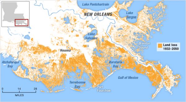
Statistics help tell the story as well. Since the 1930s, more than 1,900 square miles of Louisiana’s coastline have disappeared. Over the next 45 minutes, another 100 yards will be gobbled up by the Gulf.
According to the Louisiana Coastal Wetlands Conservation and Restoration Task Force, the Barataria Basin could lose as much as 7,125 acres of intermediate marsh by 2050 (that doesn’t include another 22,770 acres of freshwater marsh). The combined figure for Mermentau is 43,965 acres and the Teche/Vermilion Basin 5,490 acres.
No matter which way to couch it, the Bayou State’s coastline of is moving rapidly inland and is playing out in real time—right now—with new levels of flooding in places like Mandeville and on Lake Pontchartrain’s north shore. And although it’s not a new issue, saltwater intrusion into drinking water is finally causing alarm as far north as Baton Rouge, prompting officials to take steps once confined to coastal governments.
These unprecedented challenges also call for unique problem-solving. For instance, Mandeville City Councilman Rick Danielson is pressing City Hall to invest in products and technology from AquaFence, which has an office in Hammond and is headquartered in Connecticut. The company has engineered a flood prevention system, originally developed in Norway, that is portable and demountable. It provides barrier walls to hold off floodwaters with a setup that loosely resembles folding tables kept at a 90-degree angle.
The system often requires no structural changes of any kind to the building or landscape. It can be stored out of sight, yet erected with minimal manpower and in a short window of time prior to a storm surge. Moreover, AquaFence has been tested by the U.S. Army Corp of Engineers.
To protect the Mandeville lakefront, Danielson said 250 feet of six-foot AquaFence can be put up in less than an hour. Yet he admits it’s only one part of a larger solution. “We have money allocated for flood protection and I do not want to wait until the 2014 hurricane season is upon us to start considering options,” he said.
Just like it’s spawning new ideas, the encroaching coast is also creating new leaders. Closer to the Capital City, retired Army lieutenant general Russel Honoré, who saw his national profile skyrocket during Hurricane Katrina’s aftermath, has quickly made coastal issues his own. He said he will be pushing a set of “environmental justice” bills during the 2014 regular session to address a wide variety of topics like saltwater intrusion in Baton Rouge and water management statewide. He wants the Louisiana Legislature to do more.
Honoré is also considering writing a new book that would touch upon the themes contained in his legislative package, an effort that would undoubtedly bring with it a certain amount of national attention. “I want to provide people with information about the environment and Louisiana,” he said. “Our water and our wetlands would be a focus.”
As the coast, and its issues, move further inland, it brings to mind the controversial “Plan B” approach that seems to wiggle back into debates every few years. It involves drawing a line across south Louisiana and protecting everything on it and above. But that also means forsaking everything that sits below the line, from people and places to culture and economy.
For those who live below the proposed line of demarcation, and the many others who have attachments, it’s an unfathomable solution. Yet if nothing is done to stop the tide of land loss, Mother Nature may very well draw that line for us.